
Make a donation
Gear up for your next adventure:
As an Amazon Associate, this site earns from qualifying purchases at no extra cost to you.
Mehrstetten topographic map
Click on the map to display elevation.
Make a donation
Gear up for your next adventure:
As an Amazon Associate, this site earns from qualifying purchases at no extra cost to you.
About this map
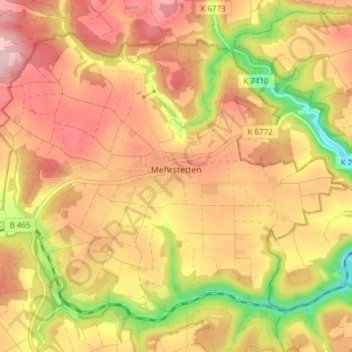
Name: Mehrstetten topographic map, elevation, terrain.
Average elevation: 2,421 ft
Minimum elevation: 2,008 ft
Maximum elevation: 2,700 ft
Make a donation
Gear up for your next adventure:
As an Amazon Associate, this site earns from qualifying purchases at no extra cost to you.
Other topographic maps
Click on a map to view its topography, its elevation and its terrain.
Traifelberg
Deutschland > Baden-Württemberg > Landkreis Reutlingen > Lichtenstein
Average elevation: 2,326 ft
Steighof
Deutschland > Baden-Württemberg > Landkreis Reutlingen > Münsingen > Bichishausen
Average elevation: 2,303 ft
Kochstetten
Deutschland > Baden-Württemberg > Landkreis Reutlingen > Hayingen
Average elevation: 2,333 ft
Make a donation
Gear up for your next adventure:
As an Amazon Associate, this site earns from qualifying purchases at no extra cost to you.
Wasserstetten
Deutschland > Baden-Württemberg > Landkreis Reutlingen > Dapfen
Average elevation: 2,372 ft
Geltungsbereich der Rechtsverordnung ehem. Truppenübungsplatz Münsingen
Deutschland > Baden-Württemberg > Landkreis Reutlingen > Gutsbezirk Münsingen
Average elevation: 2,575 ft
Make a donation
Gear up for your next adventure:
As an Amazon Associate, this site earns from qualifying purchases at no extra cost to you.
Hohe Warte
Deutschland > Baden-Württemberg > Landkreis Reutlingen > St. Johann
Average elevation: 2,441 ft
Schloss Pfullingen
Deutschland > Baden-Württemberg > Landkreis Reutlingen > Pfullingen
Average elevation: 1,499 ft
Schlossberg
Deutschland > Baden-Württemberg > Landkreis Reutlingen > Bad Urach
Average elevation: 1,844 ft
Make a donation
Gear up for your next adventure:
As an Amazon Associate, this site earns from qualifying purchases at no extra cost to you.
Donnstetten
Deutschland > Baden-Württemberg > Landkreis Reutlingen > Römerstein
Average elevation: 2,657 ft
Neuhausen an der Erms
Deutschland > Baden-Württemberg > Landkreis Reutlingen > Metzingen > Neuhausen an der Erms
Average elevation: 1,401 ft
Sirchingen
Deutschland > Baden-Württemberg > Landkreis Reutlingen > Bad Urach
Average elevation: 2,300 ft
Make a donation
Gear up for your next adventure:
As an Amazon Associate, this site earns from qualifying purchases at no extra cost to you.
Undingen
Deutschland > Baden-Württemberg > Landkreis Reutlingen > Sonnenbühl
Das Naturschutzgebiet Ruchberg liegt westlich von Willmandingen. Südwestlich von Erpfingen beginnt das Landschaftsschutzgebiet Laucherttal mit Nebentälern. Mit den Gebieten Salmendingen/Sonnenbühl, Albtrauf zwischen Mössingen und Gönningen und Albtrauf Pfullingen hat die Gemeinde Anteil an drei…
Average elevation: 2,582 ft
Steinhilben
Deutschland > Baden-Württemberg > Landkreis Reutlingen > Trochtelfingen
Average elevation: 2,556 ft
Auingen
Deutschland > Baden-Württemberg > Landkreis Reutlingen > Münsingen
Average elevation: 2,520 ft
Make a donation
Gear up for your next adventure:
As an Amazon Associate, this site earns from qualifying purchases at no extra cost to you.
Engstingen
Deutschland > Baden-Württemberg > Landkreis Reutlingen
Engstingen liegt am Nordrand der Schwäbischen Alb im Bereich der Mittleren Kuppenalb, in 680 bis 750 Meter Höhe auf der Albhochfläche oberhalb des Albtraufs. Es liegt im Tal der Ur-Lauter, etwa 15 km Luftlinie südlich der Kreisstadt Reutlingen.
Average elevation: 2,421 ft
Make a donation
Gear up for your next adventure:
As an Amazon Associate, this site earns from qualifying purchases at no extra cost to you.
Waldsiedlung Beerenhalde
Deutschland > Baden-Württemberg > Landkreis Reutlingen > Sonnenbühl
Average elevation: 2,536 ft
Willmandingen
Deutschland > Baden-Württemberg > Landkreis Reutlingen > Sonnenbühl
Das Naturschutzgebiet Ruchberg liegt westlich von Willmandingen. Südwestlich von Erpfingen beginnt das Landschaftsschutzgebiet Laucherttal mit Nebentälern. Mit den Gebieten Salmendingen/Sonnenbühl, Albtrauf zwischen Mössingen und Gönningen und Albtrauf Pfullingen hat die Gemeinde Anteil an drei…
Average elevation: 2,579 ft
Erpfingen
Deutschland > Baden-Württemberg > Landkreis Reutlingen > Sonnenbühl
Average elevation: 2,536 ft
Make a donation
Gear up for your next adventure:
As an Amazon Associate, this site earns from qualifying purchases at no extra cost to you.
Walddorf
Deutschland > Baden-Württemberg > Landkreis Reutlingen
Walddorfhäslach liegt am Rande des Naturparks Schönbuch. Das Gemeindegebiet erstreckt sich über eine Höhenlage von 336 m ü. NN im Schaichtal bis 501 m ü. NN auf der Walddorfer Platte.
Average elevation: 1,358 ft
Offenhausen
Deutschland > Baden-Württemberg > Landkreis Reutlingen > Gomadingen
Average elevation: 2,375 ft
Gächingen
Deutschland > Baden-Württemberg > Landkreis Reutlingen > St. Johann
Average elevation: 2,402 ft
Make a donation
Gear up for your next adventure:
As an Amazon Associate, this site earns from qualifying purchases at no extra cost to you.
Uhenfels
Deutschland > Baden-Württemberg > Landkreis Reutlingen > Bad Urach
Average elevation: 2,365 ft
Make a donation
Gear up for your next adventure:
As an Amazon Associate, this site earns from qualifying purchases at no extra cost to you.
Degerschlacht
Deutschland > Baden-Württemberg > Landkreis Reutlingen > Reutlingen
Average elevation: 1,234 ft
Bärenhöhle
Deutschland > Baden-Württemberg > Landkreis Reutlingen > Erpfingen
Average elevation: 2,533 ft
Ableitung Erms
Deutschland > Baden-Württemberg > Landkreis Reutlingen > Dettingen an der Erms
Average elevation: 1,581 ft
Oberwilzingen
Deutschland > Baden-Württemberg > Landkreis Reutlingen > Hayingen
Das Dorf liegt südöstlich von Hayingen auf einer Hochfläche der Schwäbischen Alb über dem Tal der Großen Lauter auf 595 Meter Meereshöhe.
Average elevation: 2,090 ft
Make a donation
Gear up for your next adventure:
As an Amazon Associate, this site earns from qualifying purchases at no extra cost to you.
Gönningen
Deutschland > Baden-Württemberg > Landkreis Reutlingen > Reutlingen
Average elevation: 1,995 ft
Trailfingen
Deutschland > Baden-Württemberg > Landkreis Reutlingen > Münsingen
Average elevation: 2,461 ft
Make a donation
Gear up for your next adventure:
As an Amazon Associate, this site earns from qualifying purchases at no extra cost to you.
Bleichstetten
Deutschland > Baden-Württemberg > Landkreis Reutlingen > St. Johann
Average elevation: 2,434 ft
Make a donation
Gear up for your next adventure:
As an Amazon Associate, this site earns from qualifying purchases at no extra cost to you.
Sickenhausen
Deutschland > Baden-Württemberg > Landkreis Reutlingen > Reutlingen
Average elevation: 1,214 ft
Sterngucker-Platz Zainigen
Deutschland > Baden-Württemberg > Landkreis Reutlingen > Gutsbezirk Münsingen
Average elevation: 2,713 ft
Traifelberg
Deutschland > Baden-Württemberg > Landkreis Reutlingen > Honau
Average elevation: 2,369 ft
Make a donation
Gear up for your next adventure:
As an Amazon Associate, this site earns from qualifying purchases at no extra cost to you.
Gundelfingen
Deutschland > Baden-Württemberg > Landkreis Reutlingen > Münsingen > Bichishausen > Gundelfingen
Average elevation: 2,297 ft
Böhringen
Deutschland > Baden-Württemberg > Landkreis Reutlingen > Römerstein > Böhringen
Average elevation: 2,543 ft
Make a donation
Gear up for your next adventure:
As an Amazon Associate, this site earns from qualifying purchases at no extra cost to you.
Meidelstetten
Deutschland > Baden-Württemberg > Landkreis Reutlingen > Hohenstein
Average elevation: 2,510 ft
Riedrichbach
Deutschland > Baden-Württemberg > Landkreis Reutlingen > Metzingen
Average elevation: 1,325 ft
Eppenzillfelshöhle
Deutschland > Baden-Württemberg > Landkreis Reutlingen > Bad Urach
Average elevation: 2,224 ft
Riederich
Deutschland > Baden-Württemberg > Landkreis Reutlingen > Riederich
Average elevation: 1,168 ft
Make a donation
Gear up for your next adventure:
As an Amazon Associate, this site earns from qualifying purchases at no extra cost to you.