Geolocate

Shaian topographic map

Click on the map to display elevation.

About this map

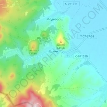
Name: Shaian topographic map, elevation, terrain.

Location: Shaian, Vyshkovo Settlement Hromada, Khust Raion, 90457, Ukraine (48.04970 23.30235 48.06723 23.36756)

Average elevation: 909 ft

Minimum elevation: 594 ft

Maximum elevation: 2,014 ft

Other topographic maps

Click on a map to view its topography, its elevation and its terrain.

Kyiv

Ukraine > Kyiv

Average elevation: 430 ft

Rivne

Ukraine > Rivne Oblast > Rivne

Average elevation: 702 ft

Bilhorod-Dnistrovskyi

Ukraine > Odesa Oblast

Average elevation: 59 ft

Drohobych

Ukraine > Lviv Oblast

Average elevation: 1,001 ft

Lviv

Ukraine > Lviv Oblast

Lviv is on the edge of the Roztochia Upland, about 70 kilometres (43 miles) east of Polish border and 160 km (99 mi) north of the eastern Carpathian Mountains. The average altitude of Lviv is 296 metres (971 feet) above sea level. Its highest point is the Vysokyi Zamok (High Castle), 409 meters (1342 feet)…

Average elevation: 1,014 ft

Kupiansk

Ukraine > Kharkiv Oblast

Average elevation: 351 ft

Verkhovyna

Ukraine > Ivano-Frankivsk Oblast

Average elevation: 2,661 ft

Horodkivka

Ukraine > Vinnytsia Oblast

Average elevation: 778 ft

Sadzhava

Ukraine > Ivano-Frankivsk Oblast

Average elevation: 1,224 ft

Crimean Peninsula

Ukraine

The main range of these mountains rises with extraordinary abruptness from the deep floor of the Black Sea to an altitude of 600–1,545 metres (1,969–5,069 ft), beginning at the southwest point of the peninsula, called Cape Fiolent. Some Greek myths state that this cape was supposedly crowned with the…

Average elevation: 115 ft

Kyiv

Ukraine

Originally on the west bank, today Kyiv is located on both sides of the Dnieper, which flows southwards through the city towards the Black Sea. The older and higher western part of the city sits on numerous wooded hills (Kyiv Hills), with ravines and small rivers. Kyiv's geographical relief contributed to its…

Average elevation: 436 ft

Mukachevo

Ukraine > Zakarpattia Oblast > Mukachevo

Average elevation: 466 ft

Kherson

Ukraine > Kherson Oblast

Average elevation: 69 ft

Khutory

Ukraine > Cherkasy Oblast

Average elevation: 305 ft

Donetsk Oblast

Ukraine

Average elevation: 404 ft

Kramatorsk

Ukraine > Donetsk Oblast

Average elevation: 404 ft

Vitrianka

Ukraine > Chernivtsi Oblast

Average elevation: 843 ft

Lyman

Ukraine > Donetsk Oblast > Lyman

Average elevation: 348 ft

Kyiv

Ukraine

Originally on the west bank, today Kyiv is on both sides of the Dnieper, which flows southwards through the city towards the Black Sea. The older and higher western part of the city sits on numerous wooded hills (Kyiv Hills), with ravines and small rivers. Kyiv's geographical relief contributed to its…

Average elevation: 436 ft

Pidhirtsi

Ukraine > Rivne Oblast

Average elevation: 682 ft

Uzhhorod

Ukraine > Zakarpattia Oblast

Average elevation: 463 ft

Donetsk

Ukraine > Donetsk Oblast

Average elevation: 643 ft

Kyiv

Ukraine

Originally on the west bank, today Kyiv is on both sides of the Dnieper, which flows southwards through the city towards the Black Sea. The older and higher western part of the city sits on numerous wooded hills (Kyiv Hills), with ravines and small rivers. Kyiv's geographical relief contributed to its…

Average elevation: 436 ft

Kostiantynivka

Ukraine > Donetsk Oblast

Average elevation: 443 ft

Irpin

Ukraine > Kyiv Oblast

Average elevation: 433 ft

Dniester

Ukraine

Average elevation: 1,145 ft

Oleksiievo-Druzhkivka

Ukraine > Donetsk Oblast

Average elevation: 331 ft

Hostomel

Ukraine > Kyiv Oblast

Average elevation: 404 ft

Orlivka

Ukraine > Chernihiv Oblast

Average elevation: 571 ft

Dnieper River

Ukraine

The source of the Dnieper is the sedge bogs (Akseninsky Mokh) of the Valdai Hills in central Russia, at an elevation of 220 m (720 ft). For 115 km (71 mi) of its length, it serves as the border between Belarus and Ukraine. Its estuary, or liman, used to be defended by the strong fortress of Ochakiv.

Average elevation: 636 ft

Kherson Oblast

Ukraine

Average elevation: 151 ft

Brovary

Ukraine > Kyiv Oblast

Average elevation: 417 ft

Sloviansk

Ukraine > Donetsk Oblast

Average elevation: 361 ft

Zhytomyr

Ukraine > Zhytomyr Oblast

Average elevation: 705 ft

Ukrainian Carpathians

Ukraine

Average elevation: 1,503 ft

Kharkiv

Ukraine > Kharkiv Oblast

Based on Kharkiv's topography, the city can be conditionally divided into four lower districts and four higher districts.

Average elevation: 479 ft

Zaporizhzhia

Ukraine > Zaporizhia Oblast

Zaporizhzhia is located in south-eastern Ukraine. The Dnieper splits the city in two; between them is Khortytsia Island. The city covers 334 km2 (129 sq mi) at an elevation of 50 m (160 ft) above sea level. The New and Old Dnieper flow past around Khortytsia: The New Dnieper [uk] is about 800 m (2,600 feet)…

Average elevation: 256 ft

Bukovets

Ukraine > Ivano-Frankivsk Oblast

Average elevation: 2,766 ft

Bakhmut

Ukraine > Donetsk Oblast

Average elevation: 456 ft

Dymka

Ukraine > Chernivtsi Oblast

Average elevation: 1,211 ft

Syrai

Ukraine > Chernihiv Oblast

Average elevation: 377 ft

Kyiv Oblast

Ukraine

Average elevation: 509 ft

Lviv

Ukraine > Lviv Oblast

Lviv is on the edge of the Roztochia Upland, about 70 kilometres (43 miles) east of the Polish border and 160 km (99 mi) north of the eastern Carpathian Mountains. The average altitude of Lviv is 296 metres (971 feet) above sea level. Its highest point is the Vysokyi Zamok (High Castle), 409 meters (1,342…

Average elevation: 1,014 ft

Chorniiv

Ukraine > Volyn Oblast

Average elevation: 692 ft

Chasiv Yar

Ukraine > Donetsk Oblast

Average elevation: 699 ft

Zaporizhia Oblast

Ukraine

The territory of Zaporizhzhia Oblast as a whole has a flat topography, but there are markedly elevated and depressed areas, which differ in shape, origin, and age.

Average elevation: 246 ft

Kharkiv

Ukraine > Kharkiv Oblast

Based on Kharkiv's topography, the city can be conditionally divided into four lower districts and four higher districts.

Average elevation: 479 ft

Ivano-Frankivsk Oblast

Ukraine

The Carpathian Mountains contribute tremendously to the change in relief of Ivano-Frankivsk Oblast and their elevation rises from north-east to south-west stretching along the oblast's south-western border. The elevation of the oblast varies from 230 m (755 ft) to 2,061 m (6,762 ft) above sea level. The…

Average elevation: 1,801 ft

Chornobyl

Ukraine > Kyiv Oblast

Average elevation: 371 ft

Zakarpattia Oblast

Ukraine

The largest rivers that flow through the oblast include the Tysa, Borzhava, and the Tereblia. A high altitude lake is located in Rakhiv Raion, which is the highest in the region. It is called Nesamovyte. The lake is located in the Hoverla preserve on the slopes of Turkul mountain. The lake's area is 3,000…

Average elevation: 1,798 ft

Kremenchuk

Ukraine > Poltava Oblast

Average elevation: 295 ft

Lyman

Ukraine > Donetsk Oblast

Average elevation: 354 ft

Turia Bystra

Ukraine

Average elevation: 1,247 ft

Odesa

Ukraine > Odesa Oblast

The city is situated on terraced hills overlooking a small harbor. The average elevation at which the city is located is around 50 metres (160 feet). The maximum is 65 metres (213 feet) and minimum (on the coast) amounts to 4.2 metres (13.8 feet) above sea level. There are three large estuaries near the city:…

Average elevation: 85 ft

Lviv

Ukraine > Lviv Oblast

Lviv is on the edge of the Roztochia Upland, about 70 kilometres (43 miles) east of Polish border and 160 km (99 mi) north of the eastern Carpathian Mountains. The average altitude of Lviv is 296 metres (971 feet) above sea level. Its highest point is the Vysokyi Zamok (High Castle), 409 meters (1342 feet)…

Average elevation: 1,014 ft

Crimean Peninsula

Ukraine

The main range of these mountains rises with extraordinary abruptness from the deep floor of the Black Sea to an altitude of 600–1,545 metres (1,969–5,069 ft), beginning at the southwest point of the peninsula, called Cape Fiolent. Some Greek myths state that this cape was supposedly crowned with the…

Average elevation: 115 ft

Rokytne Settlement Hromada

Ukraine > Rivne Oblast

Average elevation: 568 ft

Bakhmut

Ukraine > Donetsk Oblast

Bakhmut, located in the Donetsk Oblast of eastern Ukraine, lies in a region characterized by relatively flat terrain, with its elevation around 328 feet (100 meters) above sea level​. The city is situated along the Bakhmutka River, which contributes to the area's relatively mild topographic features. The…

Average elevation: 456 ft

Dubove

Ukraine > Zakarpattia Oblast

Average elevation: 1,847 ft

Odesa

Ukraine > Odesa Oblast

Odesa is situated (46°28′N 30°44′E / 46.467°N 30.733°E / 46.467; 30.733) on terraced hills overlooking a small harbor on the Black Sea in the Gulf of Odesa, approximately 31 km (19 mi) north of the estuary of the Dniester river and some 443 km (275 mi) south of the Ukrainian capital Kyiv. The…

Average elevation: 85 ft

Chasiv Yar

Ukraine > Donetsk Oblast

Average elevation: 699 ft

Soroky

Ukraine > Ternopil Oblast

Average elevation: 1,217 ft

Popilnia

Ukraine > Zhytomyr Oblast

Average elevation: 696 ft

Chornobyl

Ukraine > Kyiv Oblast

Average elevation: 371 ft

Dniester

Ukraine

Average elevation: 1,145 ft

Chuhuiv

Ukraine > Kharkiv Oblast

Average elevation: 358 ft

Fastiv

Ukraine > Kyiv Oblast

Average elevation: 617 ft

Mykolaiv

Ukraine > Mykolaiv Oblast

Mykolaiv is in a primarily flat terrain area (the steppe grain-producing region of southern Ukraine). The nearest mountains to Mykolaiv are 300 kilometres (186 miles) south, at the southern end of the Crimean Peninsula. The lack of any mountain barriers north of Mykolaiv means that very cold Arctic winds can…

Average elevation: 105 ft

Avdiivka

Ukraine > Donetsk Oblast

Average elevation: 676 ft

Sumy Oblast

Ukraine

The Sumy Oblast is situated in the northeastern part of Ukraine. It is situated on a border of two historical regions of Ukraine — Cossack Hetmanate (annexed by Russia in the 18th century as Little Russia, previously known as Severia) and Sloboda Ukraine. Elevation is 110–240m above sea level. The area of…

Average elevation: 558 ft

Ivanivka

Ukraine > Luhansk Oblast

Average elevation: 1,066 ft

Borzhava

Ukraine

Average elevation: 377 ft

Dnipro

Ukraine > Dnipropetrovsk Oblast

Under the Köppen–Geiger climate classification system, Dnipro has a humid continental climate (Dfa/Dfb). Snowfall is more common in the hills than at the city's lower elevations. The city has four distinct seasons: a cold, snowy winter; a hot summer; and two relatively wet transition periods. However,…

Average elevation: 295 ft

Lviv Oblast

Ukraine

Average elevation: 1,142 ft

Mariupol

Ukraine > Donetsk Oblast

Average elevation: 157 ft

Ivano-Frankivsk

Ukraine > Ivano-Frankivsk Oblast

Average elevation: 866 ft

Luhansk

Ukraine > Luhansk Oblast

Average elevation: 361 ft

Mykolaiv Oblast

Ukraine

Average elevation: 253 ft

Ratne

Ukraine > Volyn Oblast

Average elevation: 509 ft

Kyiv Reservoir

Ukraine > Kyiv Oblast

Average elevation: 377 ft

Novohrodivka

Ukraine > Donetsk Oblast

Average elevation: 666 ft

Sumy Oblast

Ukraine

On its territory the Dnieper Lowland transitions east to the Central Russian Upland. The northern part of Sumy Oblast is part of the Polesie Lowland as its eastern region. Elevation is 110–240 m above sea level. Its area (23,800 km2) constitutes 3.95% of the country.

Average elevation: 558 ft

Shakhove

Ukraine > Donetsk Oblast

Average elevation: 404 ft

Kotivka

Ukraine > Sumy Oblast

Average elevation: 489 ft

Sanzharivka

Ukraine > Donetsk Oblast

Average elevation: 820 ft

Pokrovske

Ukraine > Dnipropetrovsk Oblast

Average elevation: 328 ft

Ternopil

Ukraine > Ternopil Oblast

Average elevation: 1,109 ft

Vuhledar

Ukraine > Donetsk Oblast

Average elevation: 574 ft

Uzhhorod

Ukraine > Zakarpattia Oblast

Average elevation: 463 ft

Toretsk

Ukraine > Donetsk Oblast

Average elevation: 587 ft

Volovets

Ukraine > Zakarpattia Oblast

Average elevation: 2,677 ft

Gear up for your next adventure:

🪶Thermal Camp Blanket - Extra warmth for cold nights
📖Nature Tracking Books - Learn to track wildlife and terrain
🧣Merino Neck Gaiters - Multi-functional headwear for wind and sun protection
❄️Traction Cleats - Prevent slips on icy trails during winter hikes
🌧️Backpack Rain Cover - Keep gear dry in wet weather

As an Amazon Associate, this site earns from qualifying purchases at no extra cost to you.