
Make a donation
Gear up for your next adventure:
As an Amazon Associate, this site earns from qualifying purchases at no extra cost to you.
Emmaus topographic map
Click on the map to display elevation.
Make a donation
Gear up for your next adventure:
As an Amazon Associate, this site earns from qualifying purchases at no extra cost to you.
Emmaus
According to the U.S. Census Bureau, the borough has a total area of 2.9 square miles (7.5 km2), all land, though part of Little Lehigh Creek, a tributary of the Lehigh River, flows just outside the Emmaus border with Salisbury Township. Emmaus borders South Mountain, a large Appalachian mountain range. The town's elevation is 436 feet above sea level. Emmaus is located at approximately 40°32′13″N 75°29′45″W / 40.53694°N 75.49583°W / 40.53694; -75.49583. It has a hot-summer humid continental climate (Dfa) and is in hardiness zone 6b. Average monthly temperatures in the downtown vicinity range from 28.9 °F in January to 73.5 °F in July.
Make a donation
Gear up for your next adventure:
As an Amazon Associate, this site earns from qualifying purchases at no extra cost to you.
About this map
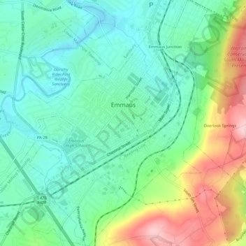
Name: Emmaus topographic map, elevation, terrain.
Location: Emmaus, Lehigh County, Pennsylvania, 18049, United States (40.51674 -75.52038 40.55645 -75.47900)
Average elevation: 505 ft
Minimum elevation: 292 ft
Maximum elevation: 971 ft
Lehigh County trails, hiking, mountain biking, running and outdoor activities
Make a donation
Gear up for your next adventure:
As an Amazon Associate, this site earns from qualifying purchases at no extra cost to you.
Other topographic maps
Click on a map to view its topography, its elevation and its terrain.
East Texas
United States > Pennsylvania > Lehigh County > Lower Macungie Township
Average elevation: 413 ft
Fogelsville
United States > Pennsylvania > Lehigh County > Upper Macungie Township
Average elevation: 509 ft
North Coplay
United States > Pennsylvania > Lehigh County > Whitehall > Cementon
Average elevation: 381 ft
Leather Corner Post
United States > Pennsylvania > Lehigh County > Lowhill Township
Average elevation: 584 ft
Make a donation
Gear up for your next adventure:
As an Amazon Associate, this site earns from qualifying purchases at no extra cost to you.
Centreville
United States > Pennsylvania > Lehigh County > Lower Macungie Township
Average elevation: 472 ft
Hillside
United States > Pennsylvania > Lehigh County > South Whitehall Township
Average elevation: 499 ft
South Mountain
United States > Pennsylvania > Lehigh County > Upper Saucon
Unlike Blue Mountain to its north, South Mountain does not follow a straight geographic line. The mountain ranges in elevation between 500 and 1,300 feet (150 and 400 m) above sea level. The ridge is made of metamorphic rocks and gneiss, which date to the Precambrian era and range from about 570 million to…
Average elevation: 502 ft
Make a donation
Gear up for your next adventure:
As an Amazon Associate, this site earns from qualifying purchases at no extra cost to you.
Limeport
United States > Pennsylvania > Lehigh County > Lower Milford Township
Average elevation: 666 ft
Orefield
United States > Pennsylvania > Lehigh County > North Whitehall Township
Average elevation: 463 ft
Wescosville
United States > Pennsylvania > Lehigh County > Lower Macungie Township
Average elevation: 420 ft
Make a donation
Gear up for your next adventure:
As an Amazon Associate, this site earns from qualifying purchases at no extra cost to you.
Fogelsville
United States > Pennsylvania > Lehigh County > Upper Macungie Township
Average elevation: 509 ft
Vera Cruz Station
United States > Pennsylvania > Lehigh County > Upper Milford Township
Average elevation: 653 ft
South Mountain
United States > Pennsylvania > Lehigh County > Upper Saucon
Unlike Blue Mountain to its north, South Mountain does not follow a straight geographic line. The mountain ranges in elevation between 500 and 1,300 feet (150 and 400 m) above sea level. The ridge is made of metamorphic rocks and gneiss, which date to the Precambrian era and range from about 570 million to…
Average elevation: 502 ft
Make a donation
Gear up for your next adventure:
As an Amazon Associate, this site earns from qualifying purchases at no extra cost to you.
Trexlertown
United States > Pennsylvania > Lehigh County > Upper Macungie Township
Trexlertown is located southwest of the center of Lehigh County along the southeastern edge of Upper Macungie Township at an altitude of 397 feet (121 m). It is bordered to the southwest by Breinigsville and to the southeast by Lower Macungie Township. U.S. Route 222 forms the northern edge of the community;…
Average elevation: 417 ft
Saegersville
United States > Pennsylvania > Lehigh County > Heidelberg Township
Average elevation: 682 ft
North Fogelsville
United States > Pennsylvania > Lehigh County > Upper Macungie Township > Fogelsville
Average elevation: 541 ft
Kernsville
United States > Pennsylvania > Lehigh County > North Whitehall Township
Average elevation: 482 ft
Make a donation
Gear up for your next adventure:
As an Amazon Associate, this site earns from qualifying purchases at no extra cost to you.
Ironton
United States > Pennsylvania > Lehigh County > North Whitehall Township
Average elevation: 518 ft
Leather Corner Post
United States > Pennsylvania > Lehigh County > Lowhill Township
Average elevation: 584 ft
Orefield
United States > Pennsylvania > Lehigh County > North Whitehall Township
Average elevation: 463 ft
Make a donation
Gear up for your next adventure:
As an Amazon Associate, this site earns from qualifying purchases at no extra cost to you.
Weilersville
United States > Pennsylvania > Lehigh County > Lower Macungie Township
Average elevation: 413 ft
Jordan Valley
United States > Pennsylvania > Lehigh County > Heidelberg Township
Average elevation: 699 ft
Cherry Hill
United States > Pennsylvania > Lehigh County > Upper Macungie Township
Average elevation: 479 ft
Weidasville
United States > Pennsylvania > Lehigh County > Lowhill Township > Weidasville
Average elevation: 558 ft
Make a donation
Gear up for your next adventure:
As an Amazon Associate, this site earns from qualifying purchases at no extra cost to you.
Crackersport
United States > Pennsylvania > Lehigh County > South Whitehall Township
Average elevation: 453 ft
Ormrod
United States > Pennsylvania > Lehigh County > North Whitehall Township
Average elevation: 486 ft