
Grisons topographic map
Interactive map
Click on the map to display elevation.
About this map
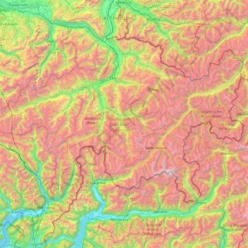
Name: Grisons topographic map, elevation, terrain.
Location: Grisons, Switzerland (46.16918 8.65106 47.06515 10.49229)
Average elevation: 5,699 ft
Minimum elevation: 620 ft
Maximum elevation: 13,127 ft
The Grisons lies fully within the Alps, with elevations above sea-level ranging from 260 to 4,049 metres (853 to 13,284 ft). It is both one of the highest and lowest cantons, and the second-highest when considering mean elevation. As a consequence, its topography is extremely rugged and many of the highest settlements in the country (and Europe) are found there, notably in the Upper Engadin. The mountains are numerous and largely over 1,000 summits can be found in the canton. The highest is Piz Bernina, closely followed by numerous peaks in the homonymous range. Other prominent mountains are Piz Russein, Piz Kesch, Calanda, Aroser Rothorn and Rheinwaldhorn, see list of mountains of Graubünden for a more exhaustive list. The canton includes numerous subranges of the Alps other than the Bernina. These are the Albula, the Bregaglia, the Glarus, the Gotthard, the Lepontine, the Livigno, the Plessur, the Oberhalbstein, the Ortler, the Rätikon, the Samnaun, the Sesvenna and the Silvretta ranges.
Other topographic maps
Click on a map to view its topography, its elevation and its terrain.
Churwalden
Switzerland > Grisons > Plessur
Churwalden, Plessur, Grisons, Switzerland
Average elevation: 5,538 ft
Basal
Switzerland > Ticino > Distretto di Leventina > Personico
Basal, Personico, Circolo di Giornico, Distretto di Leventina, Ticino, 6744, Switzerland
Average elevation: 6,781 ft
Zurich
Switzerland > Zurich > District Zurich
Zurich, District Zurich, Zurich, Switzerland
Average elevation: 1,637 ft
St. Gallen
Switzerland > St. Gallen > Wahlkreis St. Gallen
St. Gallen, Wahlkreis St. Gallen, St. Gallen, Switzerland
Average elevation: 2,431 ft
Obersee
Switzerland > St. Gallen > Wahlkreis See-Gaster > Rapperswil-Jona
Obersee, Rapperswil-Jona, Wahlkreis See-Gaster, St. Gallen, Switzerland
Average elevation: 1,755 ft
Niederwil
Switzerland > Aargau > Bezirk Bremgarten
Niederwil, Bezirk Bremgarten, Aargau, 5524, Switzerland
Average elevation: 1,401 ft
Minschuns
Switzerland > Grisons > Region Engiadina Bassa/Val Müstair > Val Müstair
Minschuns, Val Müstair, Region Engiadina Bassa/Val Müstair, Grisons, 7532, Switzerland
Average elevation: 7,454 ft
Dichtuhüs
Switzerland > Wallis > Brig > Mund
Dichtuhüs, Mund, Naters, Brig, Wallis, 3903, Switzerland
Average elevation: 4,544 ft
Mund
Switzerland > Wallis > Brig
Mund, Naters, Brig, Wallis, 3903, Switzerland
Average elevation: 4,101 ft
Chié
Switzerland > Ticino > Distretto di Leventina > Osco > Vigera
Chié, Vigera, Osco, Faido, Circolo di Faido, Distretto di Leventina, Ticino, 6763, Switzerland
Average elevation: 3,806 ft
Les Granges (Salvan)
Switzerland > Wallis > Saint-Maurice
Les Granges (Salvan), Salvan, Saint-Maurice, Wallis, 1922, Switzerland
Average elevation: 3,560 ft
Savu
Switzerland > Wallis > Entremont > Sembrancher
Savu, Sembrancher, Entremont, Wallis, 2303, Switzerland
Average elevation: 3,081 ft
Seealpsee
Switzerland > Appenzell Innerrhoden > Schwende-Rüte
Seealpsee, Schwende, Schwende-Rüte, Appenzell Innerrhoden, 9057, Switzerland
Average elevation: 4,892 ft
Scuol
Switzerland > Grisons > Region Engiadina Bassa/Val Müstair
Scuol, Region Engiadina Bassa/Val Müstair, Grisons, 7550, Switzerland
Average elevation: 7,349 ft
Vésenaz
Vésenaz, Collonge-Bellerive, Geneva, 1244, Switzerland
Average elevation: 1,352 ft
Lenzerheide
Switzerland > Grisons > Albula > Vaz/Obervaz
Lenzerheide, Vaz/Obervaz, Albula, Grisons, 7078, Switzerland
Average elevation: 5,653 ft
Sins
Switzerland > Aargau > Bezirk Muri
Sins, Bezirk Muri, Aargau, Switzerland
Average elevation: 1,526 ft
Piz Segnas
Switzerland > Grisons > Imboden > Flims
Piz Segnas, Flims, Imboden, Grisons, Switzerland
Average elevation: 8,510 ft
Nendaz
Switzerland > Wallis > Conthey
Nendaz, Conthey, Wallis, 1997, Switzerland
Average elevation: 5,810 ft
Usc
Switzerland > Ticino > Distretto di Leventina > Sobrio
Usc, Sobrio, Faido, Circolo di Faido, Distretto di Leventina, Ticino, 6749, Switzerland
Average elevation: 4,347 ft
Untersiggenthal
Switzerland > Aargau > Bezirk Baden
Untersiggenthal, Bezirk Baden, Aargau, Switzerland
Average elevation: 1,394 ft
Bettmeralp
Switzerland > Wallis > Östlich Raron
Bettmeralp, Östlich Raron, Wallis, 3992, Switzerland
Average elevation: 7,411 ft
Breil/Brigels
Switzerland > Grisons > Surselva
Breil/Brigels, Surselva, Grisons, Switzerland
Average elevation: 6,184 ft
Oberegg
Switzerland > Appenzell Innerrhoden
Oberegg, Appenzell Innerrhoden, Switzerland
Average elevation: 2,556 ft
Gruyère District
Gruyère District, Fribourg, Switzerland
Average elevation: 4,042 ft
Canaa
Switzerland > Ticino > Distretto di Vallemaggia > Maggia
Canaa, Maggia, Circolo della Maggia, Distretto di Vallemaggia, Ticino, 6673, Switzerland
Average elevation: 3,015 ft
Gomma
Switzerland > Fribourg > Sensebezirk > St. Silvester
Gomma, St. Silvester, Sensebezirk, Fribourg, 1735, Switzerland
Average elevation: 2,562 ft
Gsteig
Switzerland > Bern > Obersimmental-Saanen administrative district
Gsteig, Obersimmental-Saanen administrative district, Oberland administrative region, Bern, Switzerland
Average elevation: 6,178 ft
Frauenfeld
Switzerland > Thurgau > Bezirk Frauenfeld
Frauenfeld, Bezirk Frauenfeld, Thurgau, Switzerland
Average elevation: 1,506 ft
Seltisberg
Switzerland > Basel-Landschaft > Bezirk Liestal
Seltisberg, Bezirk Liestal, Basel-Landschaft, 4411, Switzerland
Average elevation: 1,440 ft
Losone
Switzerland > Ticino > Distretto di Locarno
Losone, Circolo dell'Isole, Distretto di Locarno, Ticino, Switzerland
Average elevation: 1,273 ft
Realp
Switzerland > Uri > Korporation Ursern
Realp, Korporation Ursern, Uri, 6491, Switzerland
Average elevation: 7,487 ft
Val de Bagnes
Switzerland > Wallis > Entremont
Val de Bagnes, Entremont, Wallis, 1934, Switzerland
Average elevation: 7,615 ft
Lausanne
Switzerland > Vaud > District de Lausanne
Lausanne, District de Lausanne, Vaud, Switzerland
Average elevation: 2,037 ft
Lauterbrunnen
Switzerland > Bern > Interlaken-Oberhasli administrative district
Lauterbrunnen, Interlaken-Oberhasli administrative district, Oberland administrative region, Bern, Switzerland
Average elevation: 7,598 ft
Costa
Switzerland > Ticino > Distretto di Locarno > Contra
Costa, Contra, Tenero-Contra, Circolo della Navegna, Distretto di Locarno, Ticino, 6598, Switzerland
Average elevation: 1,680 ft
Ancien district du Pays-d'Enhaut
Switzerland > Vaud > District de la Riviera-Pays-d’Enhaut
Ancien district du Pays-d'Enhaut, District de la Riviera-Pays-d’Enhaut, Vaud, Switzerland
Average elevation: 4,849 ft
Saas-Almagell
Switzerland > Wallis > Visp
Saas-Almagell, Visp, Wallis, 3905, Switzerland
Average elevation: 9,285 ft
Evolène
Switzerland > Wallis > Hérens
Evolène, Hérens, Wallis, 1983, Switzerland
Average elevation: 8,848 ft
Orvin
Switzerland > Bern > Bernese Jura administrative district
Orvin, Bernese Jura administrative district, Bernese Jura administrative region, Bern, 2534, Switzerland
Average elevation: 2,628 ft