Geolocate

Walmer topographic map

Click on the map to display elevation.

About this map

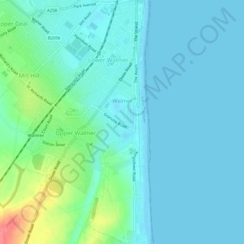
Name: Walmer topographic map, elevation, terrain.

Location: Walmer, Dover, Kent, England, United Kingdom (51.18882 1.37798 51.21952 1.40609)

Average elevation: 39 ft

Minimum elevation: 0 ft

Maximum elevation: 217 ft

Other topographic maps

Click on a map to view its topography, its elevation and its terrain.

River Stour

United Kingdom > England > Kent > Dover > Ash

Average elevation: 10 ft

Dover Castle

United Kingdom > England > Kent > Dover

Average elevation: 154 ft

Martin

United Kingdom > England > Kent > Dover

Average elevation: 230 ft

Ringwould

United Kingdom > England > Kent > Dover

Average elevation: 148 ft

Waldershare

United Kingdom > England > Kent > Dover > Tilmanstone

Average elevation: 292 ft

Kearsney

United Kingdom > England > Kent > Dover

Average elevation: 308 ft

Elmstone

United Kingdom > England > Kent > Dover > Preston

Average elevation: 43 ft

Sandwich Bay

United Kingdom > England > Kent > Dover

Average elevation: 3 ft

Westmarsh

United Kingdom > England > Kent > Dover > Ash

Average elevation: 26 ft

Ham

United Kingdom > England > Kent > Dover

Average elevation: 52 ft

Shatterling

United Kingdom > England > Kent > Dover > Staple

Average elevation: 59 ft

Church Hougham

United Kingdom > England > Kent > Dover

Average elevation: 292 ft

Wootton

United Kingdom > England > Kent > Dover

Average elevation: 390 ft

Green Lane Hill

United Kingdom > England > Kent > Dover > Whitfield

Average elevation: 305 ft

Hacklinge

United Kingdom > England > Kent > Dover > Worth

Average elevation: 33 ft

Lower Eythorne

United Kingdom > England > Kent > Dover > Eythorne

Average elevation: 246 ft

Wolverton

United Kingdom > England > Kent > Dover > Alkham > Wolverton

Average elevation: 354 ft

South Alkham

United Kingdom > England > Kent > Dover > Alkham > South Alkham

Average elevation: 404 ft

Coldred

United Kingdom > England > Kent > Dover > Shepherdswell > Coldred

Average elevation: 348 ft

Barnsole

United Kingdom > England > Kent > Dover > Staple

Average elevation: 79 ft

Richborough

United Kingdom > England > Kent > Dover

Average elevation: 13 ft

Gear up for your next adventure:

🧥Waterproof Jacket for Hiking - Breathable and rugged rain jacket for outdoor excursions
👖Convertible Hiking Pants - Versatile zip-off pants for changing altitudes and temperatures
🏕️Tent Footprint - Protect your tent base from wear
🔭Stargazing Telescopes - Perfect for camping in low-light pollution areas shown on maps
📚Navigation Handbooks - Master the art of reading topographic maps and using a compass

As an Amazon Associate, this site earns from qualifying purchases at no extra cost to you.