Geolocate
👉 Easily get elevation data in JSON, GeoTIFF and KML formats using Elevation API
Thank you for supporting this site ❤️
Make a donation

Martin topographic map

Click on the map to display elevation.

About this map

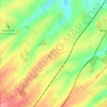
Name: Martin topographic map, elevation, terrain.

Location: Martin, Langdon, Dover, Kent, England, CT15 5JW, United Kingdom (51.15557 1.32287 51.19557 1.36287)

Average elevation: 230 ft

Minimum elevation: 85 ft

Maximum elevation: 384 ft

Other topographic maps

Click on a map to view its topography, its elevation and its terrain.

Wingham

United Kingdom > England > Kent > Dover

Average elevation: 72 ft

Dover Castle

United Kingdom > England > Kent > Dover

Average elevation: 154 ft

Ash

United Kingdom > England > Kent > Dover

Average elevation: 30 ft

Walmer

United Kingdom > England > Kent > Dover

Average elevation: 39 ft

Capel-le-Ferne

United Kingdom > England > Kent > Dover

Average elevation: 407 ft

Eastry

United Kingdom > England > Kent > Dover

Average elevation: 105 ft

River

United Kingdom > England > Kent > Dover

Average elevation: 262 ft

Stourmouth

United Kingdom > England > Kent > Dover

Average elevation: 13 ft

Woodnesborough

United Kingdom > England > Kent > Dover

Average elevation: 49 ft

Guston

United Kingdom > England > Kent > Dover

Average elevation: 302 ft

Great Mongeham

United Kingdom > England > Kent > Dover

Average elevation: 82 ft

Northbourne

United Kingdom > England > Kent > Dover

Average elevation: 85 ft

Ripple

United Kingdom > England > Kent > Dover

Average elevation: 141 ft

Staple

United Kingdom > England > Kent > Dover

Average elevation: 72 ft

Preston

United Kingdom > England > Kent > Dover

Average elevation: 33 ft

Aylesham

United Kingdom > England > Kent > Dover

Average elevation: 213 ft

Eythorne

United Kingdom > England > Kent > Dover

Average elevation: 236 ft

Alkham

United Kingdom > England > Kent > Dover

Average elevation: 390 ft

River Stour

United Kingdom > England > Kent > Dover > Ash

Average elevation: 10 ft

Sholden

United Kingdom > England > Kent > Dover

Average elevation: 13 ft

Lydden

United Kingdom > England > Kent > Dover

Average elevation: 381 ft

Sutton

United Kingdom > England > Kent > Dover > Sutton

Average elevation: 174 ft

St. Margaret's at Cliffe

United Kingdom > England > Kent > Dover

Average elevation: 174 ft

River

United Kingdom > England > Kent > Dover

Average elevation: 262 ft

River

United Kingdom > England > Kent > Dover

Average elevation: 262 ft

Ash

United Kingdom > England > Kent > Dover

Average elevation: 30 ft

Wingham

United Kingdom > England > Kent > Dover

Average elevation: 72 ft

Green Lane Hill

United Kingdom > England > Kent > Dover > Whitfield

Average elevation: 305 ft

River

United Kingdom > England > Kent > Dover

Average elevation: 262 ft

Walmer

United Kingdom > England > Kent > Dover

Average elevation: 39 ft

Whitfield

United Kingdom > England > Kent > Dover > Whitfield

Average elevation: 331 ft

River

United Kingdom > England > Kent > Dover

Average elevation: 262 ft

River

United Kingdom > England > Kent > Dover

Average elevation: 262 ft

Gear up for your next adventure:

👟Trail Running Shoes - Lightweight shoes for trail runners
🧤Hiking Gloves - Protective gloves for rugged trails
🎒Day Hiking Backpack - Lightweight backpack perfect for day trips and outdoor adventures
🗺️NatGeo Topo Maps - High-quality waterproof printed topographic maps of US Parks
📷Action Camera - Capture your outdoor adventures in HD

As an Amazon Associate, this site earns from qualifying purchases at no extra cost to you.