
Make a donation
Gear up for your next adventure:
As an Amazon Associate, this site earns from qualifying purchases at no extra cost to you.
Onaping Lake topographic map
Click on the map to display elevation.
Make a donation
Gear up for your next adventure:
As an Amazon Associate, this site earns from qualifying purchases at no extra cost to you.
About this map
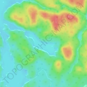
Name: Onaping Lake topographic map, elevation, terrain.
Average elevation: 1,404 ft
Minimum elevation: 1,309 ft
Maximum elevation: 1,585 ft
Make a donation
Gear up for your next adventure:
As an Amazon Associate, this site earns from qualifying purchases at no extra cost to you.
Other topographic maps
Click on a map to view its topography, its elevation and its terrain.
Chapleau River
Canada > Ontario > Sudbury District > Unorganized North Sudbury
Average elevation: 1,447 ft
Round Lake
Canada > Ontario > Sudbury District > Unorganized North Sudbury
Average elevation: 1,289 ft
Cooper Falls
Canada > Ontario > Sudbury District > Unorganized North Sudbury
Average elevation: 1,142 ft
Make a donation
Gear up for your next adventure:
As an Amazon Associate, this site earns from qualifying purchases at no extra cost to you.
Murdock River
Canada > Ontario > Sudbury District > Unorganized North Sudbury
Average elevation: 735 ft
Whitefish Falls
Canada > Ontario > Sudbury District > Unorganized North Sudbury
Average elevation: 673 ft
Spanish Chutes
Canada > Ontario > Sudbury District > Unorganized North Sudbury
Average elevation: 1,394 ft
Ishpatina Ridge Fire Tower
Canada > Ontario > Sudbury District > Unorganized North Sudbury
Average elevation: 1,788 ft
Make a donation
Gear up for your next adventure:
As an Amazon Associate, this site earns from qualifying purchases at no extra cost to you.
Georgia Lake
Canada > Ontario > Sudbury District > Unorganized North Sudbury
Average elevation: 1,457 ft
Willisville
Canada > Ontario > Sudbury District > Unorganized North Sudbury > Whitefish Falls
Average elevation: 719 ft
Jerry Lake
Canada > Ontario > Sudbury District > Unorganized North Sudbury
Average elevation: 1,247 ft
Sandcherry Creek
Canada > Ontario > Sudbury District > Unorganized North Sudbury
Average elevation: 1,388 ft
Make a donation
Gear up for your next adventure:
As an Amazon Associate, this site earns from qualifying purchases at no extra cost to you.
Whitefish River
Canada > Ontario > Sudbury District > Unorganized North Sudbury > Whitefish Falls
Average elevation: 640 ft
Mackie Lake
Canada > Ontario > Sudbury District > Unorganized North Sudbury
Average elevation: 1,473 ft
Redstone Lake
Canada > Ontario > Sudbury District > Unorganized North Sudbury
Average elevation: 1,184 ft
Make a donation
Gear up for your next adventure:
As an Amazon Associate, this site earns from qualifying purchases at no extra cost to you.
Shining Tree
Canada > Ontario > Sudbury District > Unorganized North Sudbury
Average elevation: 1,257 ft
Chiniguchi River
Canada > Ontario > Sudbury District > Unorganized North Sudbury
Average elevation: 853 ft
Halfway Lake Provincial Park
Canada > Ontario > Sudbury District > Unorganized North Sudbury
Average elevation: 1,444 ft
Spanish Lake
Canada > Ontario > Sudbury District > Unorganized North Sudbury
Average elevation: 1,227 ft
Make a donation
Gear up for your next adventure:
As an Amazon Associate, this site earns from qualifying purchases at no extra cost to you.
Beaver Lake
Canada > Ontario > Sudbury District > Unorganized North Sudbury
Average elevation: 1,381 ft
Birch Island
Canada > Ontario > Sudbury District > Unorganized North Sudbury
Average elevation: 1,234 ft