
Birch Island topographic map
Click on the map to display elevation.
About this map
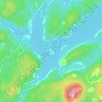
Name: Birch Island topographic map, elevation, terrain.
Average elevation: 1,234 ft
Minimum elevation: 1,102 ft
Maximum elevation: 1,617 ft
Other topographic maps
Click on a map to view its topography, its elevation and its terrain.
Nepewassi Lake
Canada > Ontario > Sudbury District > Unorganized North Sudbury
Average elevation: 732 ft
Round Lake
Canada > Ontario > Sudbury District > Unorganized North Sudbury
Average elevation: 1,289 ft
Tatachikapika Lake
Canada > Ontario > Sudbury District > Unorganized North Sudbury
Average elevation: 1,263 ft
Mattagami Lake
Canada > Ontario > Sudbury District > Unorganized North Sudbury > Mattagami
Average elevation: 1,207 ft
Onaping Lake
Canada > Ontario > Sudbury District > Unorganized North Sudbury
Average elevation: 1,404 ft
Ridout Lake
Canada > Ontario > Sudbury District > Unorganized North Sudbury
Average elevation: 1,342 ft
Murdock River
Canada > Ontario > Sudbury District > Unorganized North Sudbury
Average elevation: 735 ft
Chapleau River
Canada > Ontario > Sudbury District > Unorganized North Sudbury
Average elevation: 1,447 ft
Spanish Lake
Canada > Ontario > Sudbury District > Unorganized North Sudbury
Average elevation: 1,227 ft
Dividing Lake
Canada > Ontario > Sudbury District > Unorganized North Sudbury
Average elevation: 1,283 ft
Beaver Lake
Canada > Ontario > Sudbury District > Unorganized North Sudbury
Average elevation: 1,381 ft
McLennan Creek;Moodie Lake
Canada > Ontario > Sudbury District > Unorganized North Sudbury
Average elevation: 1,496 ft
Spanish River Provincial Park
Canada > Ontario > Sudbury District > Unorganized North Sudbury
Average elevation: 1,345 ft
Georgia Lake
Canada > Ontario > Sudbury District > Unorganized North Sudbury
Average elevation: 1,457 ft
Jerry Lake
Canada > Ontario > Sudbury District > Unorganized North Sudbury
Average elevation: 1,247 ft
Wakami Lake
Canada > Ontario > Sudbury District > Unorganized North Sudbury
Average elevation: 1,529 ft
Sandcherry Creek
Canada > Ontario > Sudbury District > Unorganized North Sudbury
Average elevation: 1,388 ft
West Shining Tree Lake
Canada > Ontario > Sudbury District > Unorganized North Sudbury > Shining Tree
Average elevation: 1,247 ft
Whitefish River
Canada > Ontario > Sudbury District > Unorganized North Sudbury > Whitefish Falls
Average elevation: 640 ft
Ministic Lake
Canada > Ontario > Sudbury District > Unorganized North Sudbury
Average elevation: 1,260 ft
Mackie Lake
Canada > Ontario > Sudbury District > Unorganized North Sudbury
Average elevation: 1,473 ft
Redstone Lake
Canada > Ontario > Sudbury District > Unorganized North Sudbury
Average elevation: 1,184 ft
Bennet Lake
Canada > Ontario > Sudbury District > Unorganized North Sudbury
Average elevation: 1,371 ft
Chiniguchi River
Canada > Ontario > Sudbury District > Unorganized North Sudbury
Average elevation: 853 ft
Low Water Lake
Canada > Ontario > Sudbury District > Unorganized North Sudbury
Average elevation: 1,401 ft