
Make a donation
Gear up for your next adventure:
As an Amazon Associate, this site earns from qualifying purchases at no extra cost to you.
Saalow topographic map
Click on the map to display elevation.
Make a donation
Gear up for your next adventure:
As an Amazon Associate, this site earns from qualifying purchases at no extra cost to you.
Saalow
Der Westen der Gemarkung ist großenteils bewaldet und erreicht im Saalower Höllenberg eine Höhe von 69,5 m. Im Süden berührt der Schneidegraben die Gemarkung. Am nördlichen Rand der Gemarkung entwässert der Saalower Graben zum verlandenden Hechtsee.
Make a donation
Gear up for your next adventure:
As an Amazon Associate, this site earns from qualifying purchases at no extra cost to you.
About this map
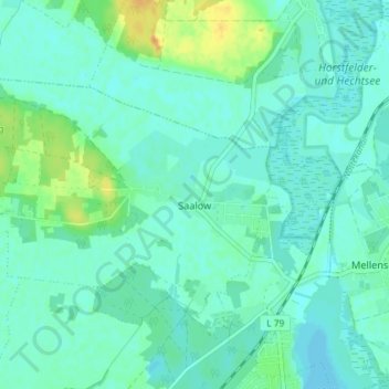
Name: Saalow topographic map, elevation, terrain.
Location: Saalow, Am Mellensee, Teltow-Fläming, Brandenburg, Deutschland (52.18063 13.33562 52.20766 13.40810)
Average elevation: 135 ft
Minimum elevation: 112 ft
Maximum elevation: 207 ft
Make a donation
Gear up for your next adventure:
As an Amazon Associate, this site earns from qualifying purchases at no extra cost to you.
Other topographic maps
Click on a map to view its topography, its elevation and its terrain.
Make a donation
Gear up for your next adventure:
As an Amazon Associate, this site earns from qualifying purchases at no extra cost to you.
Schloss Zossen
Deutschland > Brandenburg > Teltow-Fläming > Zossen > Finkenherd
Die Schlossanlage entstand im 13. Jahrhundert auf einer kleinen Anhöhe als Wasserburg vermutlich auf einem ehemaligen slawischen Burgwall als markgräflich-meißnerische Grenzfeste. Zossen gehörte vor 1349 der Familie zu Torgau (Towgow), deren Besitz von Karl IV. bestätigt worden war. Die Burg stellte dabei…
Average elevation: 125 ft
Make a donation
Gear up for your next adventure:
As an Amazon Associate, this site earns from qualifying purchases at no extra cost to you.
Mönningfeld
Deutschland > Brandenburg > Teltow-Fläming > Am Mellensee > Fernneuendorf
Average elevation: 161 ft
Naturpark Nuthe-Nieplitz
Deutschland > Brandenburg > Teltow-Fläming
Ein erheblicher Teil der Parkfläche entfällt auf die Großgemeinde Nuthe-Urstromtal. Vierzehn der dreiundzwanzig Dörfer und rund zwei Fünftel der mit 335 km² sehr ausgedehnten Fläche dieser Gemeinde liegen im Naturpark. Mit 13.265 ha nehmen Naturschutzgebiete 21 % und mit 41.700 ha ein…
Average elevation: 187 ft
Schmachtenhagen
Deutschland > Brandenburg > Teltow-Fläming > Zossen > Dabendorf
Average elevation: 138 ft
Make a donation
Gear up for your next adventure:
As an Amazon Associate, this site earns from qualifying purchases at no extra cost to you.