
Neretva topographic map
Click on the map to display elevation.
Neretva
Its source and headwaters gorge are situated deep in the Dinaric Alps at the base of the Zelengora and Lebršnik mountains, specifically under the Gredelj saddle. The river source is at 1,227 meters above sea level and consists of five small and distinct wellsprings. On its 90 kilometers course through the first section the Neretva cuts two distinct deep and narrow canyons and two distinct wide and fertile valleys, around Ulog and then Župa Komska, wider area around Glavatičevo, before it reaches town of Konjic. This section is also better known as the Upper Neretva (Serbo-Croatian: Gornja Neretva), and here river flows generally from east-southeast to north-northwest as do most Bosnia and Herzegovina rivers belonging to the Danube watershed, and covers some 1,390 square kilometres (540 sq mi) with an average elevation of 1.2%. Right below Konjic, the Neretva again expands into a third and largest valley which provided fertile agricultural land before it was flooded by large artificial reservoir, Jablaničko Lake, formed after construction of a Jablanica Dam near town of Jablanica.
About this map
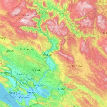
Name: Neretva topographic map, elevation, terrain.
Average elevation: 2,579 ft
Minimum elevation: -13 ft
Maximum elevation: 7,192 ft
Other topographic maps
Click on a map to view its topography, its elevation and its terrain.
Jablanica
Bosnia and Herzegovina > Federation of Bosnia and Herzegovina
The mean elevation of Jablanica is 202 metres (663 ft) above sea level. Some 69% of the municipality's land area (approx. 93 km²) is forested. Jablanica's lake ("Jablaničko") is an important geographical as well as an economic presence in Jablanica.
Average elevation: 1,535 ft
Fortica
Bosnia and Herzegovina > Federation of Bosnia and Herzegovina > City of Mostar > Suhi Do
Average elevation: 1,188 ft
Čuhovići
Bosnia and Herzegovina > Federation of Bosnia and Herzegovina > City of Konjic
Average elevation: 4,659 ft
Đulina rupa
Bosnia and Herzegovina > Federation of Bosnia and Herzegovina > Trnovo Municipality (FBiH)
Average elevation: 6,106 ft
Tuzla
Bosnia and Herzegovina > Federation of Bosnia and Herzegovina > City of Tuzla
Average elevation: 1,145 ft
Visoko
Bosnia and Herzegovina > Federation of Bosnia and Herzegovina > Grad Visoko
The Visoko municipality covers 232 square kilometres with several characteristic, morphologically distinctive valleys formed by the foothills of the Central Bosnian mountains including Ozren, Vranica and Zvijezda. The altitude of the region ranges from 400 to 1,050 metres. Visoko's natural environment is…
Average elevation: 1,729 ft
Srhinje
Bosnia and Herzegovina > Federation of Bosnia and Herzegovina > Grad Visoko
Average elevation: 1,729 ft
Visoko
Bosnia and Herzegovina > Federation of Bosnia and Herzegovina > Grad Visoko
The Visoko municipality covers 232 square kilometres with several characteristic, morphologically distinctive valleys formed by the foothills of the Central Bosnian mountains including Ozren, Vranica and Zvijezda. The altitude of the region ranges from 400 to 1,050 metres. Visoko's natural environment is…
Average elevation: 1,729 ft
Gradačac
Bosnia and Herzegovina > Federation of Bosnia and Herzegovina > Town of Gradačac
Average elevation: 554 ft
Jezero
Bosnia and Herzegovina > Federation of Bosnia and Herzegovina > Town of Konjic
Average elevation: 2,579 ft
Fra Grge Martića
Bosnia and Herzegovina > Federation of Bosnia and Herzegovina > Kreševo
Average elevation: 2,372 ft
Livno
Bosnia and Herzegovina > Federation of Bosnia and Herzegovina > City of Livno
Average elevation: 2,976 ft
Živinice
Bosnia and Herzegovina > Federation of Bosnia and Herzegovina > Town of Živinice
Average elevation: 771 ft
Gradačac
Bosnia and Herzegovina > Federation of Bosnia and Herzegovina > Town of Gradačac
Average elevation: 554 ft
Konjic
Bosnia and Herzegovina > Federation of Bosnia and Herzegovina > Town of Konjic
Average elevation: 1,804 ft
Bugojno
Bosnia and Herzegovina > Federation of Bosnia and Herzegovina
The municipality has an average elevation of 570 metres above sea level. Much of its 366 km2 is forested. The terrain is mountainous with several prominent features. Stožer (1662m), Kalin (1,530m) and Rudina (1,385m) are the tallest mountains in Bugojno.
Average elevation: 2,123 ft
Gračanica
Bosnia and Herzegovina > Federation of Bosnia and Herzegovina > Town of Gračanica
Average elevation: 876 ft
Međugorje
Bosnia and Herzegovina > Federation of Bosnia and Herzegovina
The name Medjugorje literally means "between mountains". At an altitude of 200 m (660 ft) above sea level it has a mild Mediterranean climate. The town consists of an ethnically homogeneous Croat population of 2,306. The Catholic parish includes four neighbouring villages: Bijakovići, Vionica, Miletina and…
Average elevation: 666 ft
Višća Donja
Bosnia and Herzegovina > Federation of Bosnia and Herzegovina > Town of Živinice
Average elevation: 922 ft
Zavidovići
Bosnia and Herzegovina > Federation of Bosnia and Herzegovina > Town of Zavidovići
Average elevation: 1,083 ft
Goražde
Bosnia and Herzegovina > Federation of Bosnia and Herzegovina > City of Goražde > MZ Goražde 2
Average elevation: 1,903 ft
Tomislavgrad
Bosnia and Herzegovina > Federation of Bosnia and Herzegovina
Average elevation: 2,995 ft
Tomislavgrad
Bosnia and Herzegovina > Federation of Bosnia and Herzegovina
Average elevation: 2,995 ft
Vareš
Bosnia and Herzegovina > Federation of Bosnia and Herzegovina
The Vareš region also has possibilities for winter tourism development. Due to its position and elevation snow stays longer than in other regions, and the beautiful areas surrounding it are really good for skiing and skating. The mountain resort Doli is located on Zvijezda Mountain.
Average elevation: 3,579 ft
Dinaric Alps
Bosnia and Herzegovina > Federation of Bosnia and Herzegovina > City of Livno
Average elevation: 5,246 ft
Mosor
Bosnia and Herzegovina > Federation of Bosnia and Herzegovina > City of Široki Brijeg > Gostuša
Average elevation: 2,077 ft
Tuzla
Bosnia and Herzegovina > Federation of Bosnia and Herzegovina > City of Tuzla
Average elevation: 1,145 ft
Livno
Bosnia and Herzegovina > Federation of Bosnia and Herzegovina > City of Livno
Average elevation: 2,976 ft
Kupres
Bosnia and Herzegovina > Federation of Bosnia and Herzegovina
Kupres is located at an altitude between 1,120 and 1,250 m (3,675 and 4,101 ft) and averages 55 days a year of snowfall due to its advantageous location in the Dinaric Alps.
Average elevation: 4,114 ft
Prenj
Bosnia and Herzegovina > Federation of Bosnia and Herzegovina > Town of Stolac
Average elevation: 554 ft
Livno
Bosnia and Herzegovina > Federation of Bosnia and Herzegovina > City of Livno
Average elevation: 2,976 ft
Vareš
Bosnia and Herzegovina > Federation of Bosnia and Herzegovina
The Vareš region also has possibilities for winter tourism development. Due to its position and elevation snow stays longer than in other regions, and the beautiful areas surrounding it are really good for skiing and skating. The mountain resort Doli is located on Zvijezda Mountain.
Average elevation: 3,579 ft
Tešanj
Bosnia and Herzegovina > Federation of Bosnia and Herzegovina
Tešanj is located at an altitude of 230 meters and developed around the river Tešanjka. The town is surrounded by many hills.
Average elevation: 965 ft
Visoko
Bosnia and Herzegovina > Federation of Bosnia and Herzegovina > Grad Visoko
The Visoko municipality covers 232 square kilometres with several characteristic, morphologically distinctive valleys formed by the foothills of the Central Bosnian mountains including Ozren, Vranica and Zvijezda. The altitude of the region ranges from 400 to 1,050 metres. Visoko's natural environment is…
Average elevation: 1,729 ft
Ripač
Bosnia and Herzegovina > Federation of Bosnia and Herzegovina > City of Bihać
Average elevation: 1,037 ft
Dinara
Bosnia and Herzegovina > Federation of Bosnia and Herzegovina > City of Livno
Average elevation: 3,123 ft
Donja Bukovica
Bosnia and Herzegovina > Federation of Bosnia and Herzegovina
Average elevation: 1,476 ft
Trubar
Bosnia and Herzegovina > Federation of Bosnia and Herzegovina > City of Bihać
Average elevation: 2,270 ft
Džanani
Bosnia and Herzegovina > Federation of Bosnia and Herzegovina > City of Cazin > Šturlić
Average elevation: 1,132 ft
Zenica
Bosnia and Herzegovina > Federation of Bosnia and Herzegovina > City of Zenica
The city is geographically located in the heart of Bosnia. The settled area is 43.01 km2 (16.61 sq mi) and of the city proper covers 558.5 km2 (215.6 sq mi). Elevation is 310–350 m (1,017–1,148 ft). The rivers Bosna, Lašva, Babina, and Kočeva flow through the settlement. A moderate continental climate…
Average elevation: 2,395 ft
Rodoč
Bosnia and Herzegovina > Federation of Bosnia and Herzegovina > City of Mostar > Local community Rodoč I
Average elevation: 433 ft
Čapljina
Bosnia and Herzegovina > Federation of Bosnia and Herzegovina > City of Čapljina
Average elevation: 322 ft
Visoko
Bosnia and Herzegovina > Federation of Bosnia and Herzegovina > Grad Visoko
The Visoko municipality covers 232 square kilometres with several characteristic, morphologically distinctive valleys formed by the foothills of the Central Bosnian mountains including Ozren, Vranica and Zvijezda. The altitude of the region ranges from 400 to 1,050 metres. Visoko's natural environment is…
Average elevation: 1,729 ft
Vranica
Bosnia and Herzegovina > Federation of Bosnia and Herzegovina > City of Zenica
Average elevation: 2,789 ft
Livno
Bosnia and Herzegovina > Federation of Bosnia and Herzegovina > City of Livno
Average elevation: 2,976 ft
Tuzla
Bosnia and Herzegovina > Federation of Bosnia and Herzegovina > City of Tuzla
Average elevation: 1,145 ft
Hodbina
Bosnia and Herzegovina > Federation of Bosnia and Herzegovina > City of Mostar
Average elevation: 417 ft
Cazin
Bosnia and Herzegovina > Federation of Bosnia and Herzegovina > City of Cazin
Average elevation: 1,230 ft
Ljubuški
Bosnia and Herzegovina > Federation of Bosnia and Herzegovina > Grad Ljubuški
Average elevation: 436 ft
Dinara
Bosnia and Herzegovina > Federation of Bosnia and Herzegovina > City of Livno
Average elevation: 3,123 ft
Kraljeva Sutjeska
Bosnia and Herzegovina > Federation of Bosnia and Herzegovina
Average elevation: 2,280 ft
Konjic
Bosnia and Herzegovina > Federation of Bosnia and Herzegovina > Town of Konjic
Average elevation: 1,804 ft
Banjani
Bosnia and Herzegovina > Federation of Bosnia and Herzegovina > Town of Bosanska Krupa
Average elevation: 1,010 ft
Posušje
Bosnia and Herzegovina > Federation of Bosnia and Herzegovina
It lies in the Posuško polje, at an altitude of 675 m, at the intersection of the road from Split and Imotski in Croatia towards Tomislavgrad and Mostar.
Average elevation: 2,467 ft
Tukovi
Bosnia and Herzegovina > Federation of Bosnia and Herzegovina > City of Bihać
Average elevation: 2,726 ft
Lukavac
Bosnia and Herzegovina > Federation of Bosnia and Herzegovina > Town of Lukavac
Average elevation: 728 ft
Nahorevo
Bosnia and Herzegovina > Federation of Bosnia and Herzegovina > City of Sarajevo
Average elevation: 2,835 ft
Greb
Bosnia and Herzegovina > Federation of Bosnia and Herzegovina > Markovići
Average elevation: 3,219 ft
Gornja Breza
Bosnia and Herzegovina > Federation of Bosnia and Herzegovina
Average elevation: 2,031 ft