
Make a donation
Gear up for your next adventure:
As an Amazon Associate, this site earns from qualifying purchases at no extra cost to you.
Swansea topographic map
Click on the map to display elevation.
Make a donation
Gear up for your next adventure:
As an Amazon Associate, this site earns from qualifying purchases at no extra cost to you.
About this map
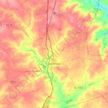
Name: Swansea topographic map, elevation, terrain.
Location: Swansea, Lexington County, South Carolina, United States (33.69533 -81.13212 33.79917 -81.08923)
Average elevation: 384 ft
Minimum elevation: 184 ft
Maximum elevation: 492 ft
Lexington County trails, hiking, mountain biking, running and outdoor activities
Make a donation
Gear up for your next adventure:
As an Amazon Associate, this site earns from qualifying purchases at no extra cost to you.
Other topographic maps
Click on a map to view its topography, its elevation and its terrain.
Peachtree Rock Heritage Preserve
United States > South Carolina > Lexington County
Average elevation: 486 ft
Batesburg
United States > South Carolina > Lexington County > Batesburg-Leesville
Average elevation: 610 ft
Make a donation
Gear up for your next adventure:
As an Amazon Associate, this site earns from qualifying purchases at no extra cost to you.
Make a donation
Gear up for your next adventure:
As an Amazon Associate, this site earns from qualifying purchases at no extra cost to you.
Edenwood
United States > South Carolina > Lexington County > Cayce > Edenwood
Average elevation: 167 ft
Make a donation
Gear up for your next adventure:
As an Amazon Associate, this site earns from qualifying purchases at no extra cost to you.