
Make a donation
Gear up for your next adventure:
As an Amazon Associate, this site earns from qualifying purchases at no extra cost to you.
Elk Grove topographic map
Click on the map to display elevation.
Make a donation
Gear up for your next adventure:
As an Amazon Associate, this site earns from qualifying purchases at no extra cost to you.
About this map
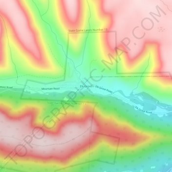
Name: Elk Grove topographic map, elevation, terrain.
Location: Elk Grove, Columbia County, Pennsylvania, United States (41.28619 -76.42689 41.32619 -76.38689)
Average elevation: 1,752 ft
Minimum elevation: 1,027 ft
Maximum elevation: 2,336 ft
Columbia County trails, hiking, mountain biking, running and outdoor activities
Make a donation
Gear up for your next adventure:
As an Amazon Associate, this site earns from qualifying purchases at no extra cost to you.
Other topographic maps
Click on a map to view its topography, its elevation and its terrain.
Sugarloaf Township
United States > Pennsylvania > Columbia County
Sugarloaf Township is located in the northeast corner of Columbia County, and is bordered to the north by Sullivan County and to the east by Luzerne County. Most of the township is rolling hills, with elevations ranging from 850 to 1,300 feet (260 to 400 m), while the northern part of the township contains the…
Average elevation: 1,289 ft
Make a donation
Gear up for your next adventure:
As an Amazon Associate, this site earns from qualifying purchases at no extra cost to you.
Make a donation
Gear up for your next adventure:
As an Amazon Associate, this site earns from qualifying purchases at no extra cost to you.
Buckhorn
United States > Pennsylvania > Columbia County > Buckhorn > Buckhorn
Average elevation: 646 ft
Make a donation
Gear up for your next adventure:
As an Amazon Associate, this site earns from qualifying purchases at no extra cost to you.
Iola
United States > Pennsylvania > Columbia County > Greenwood Township > Iola
Average elevation: 843 ft
Make a donation
Gear up for your next adventure:
As an Amazon Associate, this site earns from qualifying purchases at no extra cost to you.
Lightstreet
United States > Pennsylvania > Columbia County > Scott Township > Lightstreet
Average elevation: 689 ft
Make a donation
Gear up for your next adventure:
As an Amazon Associate, this site earns from qualifying purchases at no extra cost to you.
Locustdale
United States > Pennsylvania > Columbia County > Conyngham Township
Average elevation: 1,266 ft
Numidia
United States > Pennsylvania > Columbia County > Locust Township > Numidia
Average elevation: 978 ft
Make a donation
Gear up for your next adventure:
As an Amazon Associate, this site earns from qualifying purchases at no extra cost to you.
Wilburton Number One
United States > Pennsylvania > Columbia County > Conyngham Township
Wilburton Number One is on the top of a mountain, at an elevation of 1,540 feet (470 m). Wilburton Number One's land is a mixture of forest and residential.
Average elevation: 1,440 ft
Make a donation
Gear up for your next adventure:
As an Amazon Associate, this site earns from qualifying purchases at no extra cost to you.
Hemlock Creek
United States > Pennsylvania > Columbia County > Buckhorn > Buckhorn
Average elevation: 679 ft