
Whitfield topographic map
Click on the map to display elevation.
About this map
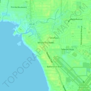
Name: Whitfield topographic map, elevation, terrain.
Location: Whitfield, Manatee County, Florida, United States (27.39272 -82.57934 27.42524 -82.55495)
Average elevation: 20 ft
Minimum elevation: -3 ft
Maximum elevation: 43 ft
Manatee County trails, hiking, mountain biking, running and outdoor activities
Other topographic maps
Click on a map to view its topography, its elevation and its terrain.
Parrish
United States > Florida > Manatee County
Parrish features a predominantly flat terrain with an average elevation of approximately 36 feet above sea level. The area's landscape is characterized by gently rolling hills and low-lying regions, making it typical of the Central Florida topography. Surrounding Parrish are numerous wetlands and drainage…
Average elevation: 39 ft
Bradenton
United States > Florida > Manatee County
Bradenton features a predominantly flat and gently undulating terrain typical of the region. The city is situated near the confluence of the Manatee River, which meanders through the area and flows into the Gulf of Mexico, creating a series of lush riverbanks and estuaries that support diverse ecosystems.…
Average elevation: 16 ft
Myakka City
United States > Florida > Manatee County
Myakka City (also Myakka) is an unincorporated community in southeastern Manatee County, Florida, United States. It lies along State Road 70 near the city of Bradenton, the county seat of Manatee County. Its elevation is 43 feet (13 m), and it is located at 27°20′59″N 82°9′41″W / 27.34972°N…
Average elevation: 46 ft
Bradenton
United States > Florida > Manatee County
Bradenton was affected by World War II like many other cities in Florida and the United States. During the war, Manatee County had its own Civil Defense battalion in it with two subunits existing in Bradenton and another for nearby Manatee. A recreational center was opened in March 1942 at a building on the…
Average elevation: 16 ft
Myakka City
United States > Florida > Manatee County
Myakka City (also Myakka) is an unincorporated community in southeastern Manatee County, Florida, United States. It lies along State Road 70 near the city of Bradenton, the county seat of Manatee County. Its elevation is 43 feet (13 m), and it is located at 27°20′59″N 82°9′41″W / 27.34972°N…
Average elevation: 46 ft
Bradenton
United States > Florida > Manatee County
Bradenton was affected by World War II like many other cities in Florida and the United States. During the war, Manatee County had its own Civil Defense battalion in it with two subunits existing in Bradenton and another for nearby Manatee. A recreational center was opened in March 1942 at a building on the…
Average elevation: 16 ft
Bradenton
United States > Florida > Manatee County
Bradenton would be affected by World War II like many other cities in Florida and the United States. During the war, Manatee County would have its own Civil Defense battalion in it with two subunits existing in Bradenton and another for nearby Manatee. A recreational center would be opened in March 1942 at a…
Average elevation: 16 ft
Bradenton
United States > Florida > Manatee County
Bradenton was affected by World War II like many other cities in Florida and the United States. During the war, Manatee County had its own Civil Defense battalion in it with two subunits existing in Bradenton and another for nearby Manatee. A recreational center was opened in March 1942 at a building on the…
Average elevation: 16 ft