
Make a donation
Gear up for your next adventure:
As an Amazon Associate, this site earns from qualifying purchases at no extra cost to you.
Bradenton topographic map
Click on the map to display elevation.
Make a donation
Gear up for your next adventure:
As an Amazon Associate, this site earns from qualifying purchases at no extra cost to you.
About this map
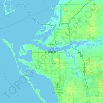
Name: Bradenton topographic map, elevation, terrain.
Location: Bradenton, Manatee County, Florida, 34205, United States (27.33893 -82.73482 27.65893 -82.41482)
Average elevation: 16 ft
Minimum elevation: -13 ft
Maximum elevation: 118 ft
Manatee County trails, hiking, mountain biking, running and outdoor activities
Make a donation
Gear up for your next adventure:
As an Amazon Associate, this site earns from qualifying purchases at no extra cost to you.
Other topographic maps
Click on a map to view its topography, its elevation and its terrain.
Anna Maria island
United States > Florida > Manatee County
Anna Maria Island features a flat, sandy topography typical of a barrier island on the Gulf Coast. With an average elevation of around 15 feet above sea level, the terrain includes broad beaches, low dunes, and narrow stretches of sandy soil, making it highly vulnerable to storm surges and tidal flooding. The…
Average elevation: 7 ft
Bradenton
United States > Florida > Manatee County
Bradenton features a predominantly flat and gently undulating terrain typical of the region. The city is situated near the confluence of the Manatee River, which meanders through the area and flows into the Gulf of Mexico, creating a series of lush riverbanks and estuaries that support diverse ecosystems.…
Average elevation: 16 ft
Make a donation
Gear up for your next adventure:
As an Amazon Associate, this site earns from qualifying purchases at no extra cost to you.
Make a donation
Gear up for your next adventure:
As an Amazon Associate, this site earns from qualifying purchases at no extra cost to you.
Make a donation
Gear up for your next adventure:
As an Amazon Associate, this site earns from qualifying purchases at no extra cost to you.
West Samoset
United States > Florida > Manatee County > South Bradenton > West Samoset
Average elevation: 36 ft
Make a donation
Gear up for your next adventure:
As an Amazon Associate, this site earns from qualifying purchases at no extra cost to you.
Make a donation
Gear up for your next adventure:
As an Amazon Associate, this site earns from qualifying purchases at no extra cost to you.
Make a donation
Gear up for your next adventure:
As an Amazon Associate, this site earns from qualifying purchases at no extra cost to you.
Make a donation
Gear up for your next adventure:
As an Amazon Associate, this site earns from qualifying purchases at no extra cost to you.
Bradenton
United States > Florida > Manatee County
Bradenton was affected by World War II like many other cities in Florida and the United States. During the war, Manatee County had its own Civil Defense battalion in it with two subunits existing in Bradenton and another for nearby Manatee. A recreational center was opened in March 1942 at a building on the…
Average elevation: 16 ft
Make a donation
Gear up for your next adventure:
As an Amazon Associate, this site earns from qualifying purchases at no extra cost to you.
Make a donation
Gear up for your next adventure:
As an Amazon Associate, this site earns from qualifying purchases at no extra cost to you.
Bradenton
United States > Florida > Manatee County
Bradenton would be affected by World War II like many other cities in Florida and the United States. During the war, Manatee County would have its own Civil Defense battalion in it with two subunits existing in Bradenton and another for nearby Manatee. A recreational center would be opened in March 1942 at a…
Average elevation: 16 ft
Bradenton
United States > Florida > Manatee County
Bradenton was affected by World War II like many other cities in Florida and the United States. During the war, Manatee County had its own Civil Defense battalion in it with two subunits existing in Bradenton and another for nearby Manatee. A recreational center was opened in March 1942 at a building on the…
Average elevation: 16 ft