
Nevada topographic map
Click on the map to display elevation.
About this map
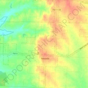
Name: Nevada topographic map, elevation, terrain.
Location: Nevada, Collin County, Texas, United States (33.01979 -96.41437 33.08014 -96.35321)
Average elevation: 587 ft
Minimum elevation: 502 ft
Maximum elevation: 663 ft
Collin County trails, hiking, mountain biking, running and outdoor activities
Other topographic maps
Click on a map to view its topography, its elevation and its terrain.
Frisco
United States > Texas > Collin County > Frisco
When the Dallas area was being settled by American pioneers, many of the settlers traveled by wagon trains along the Shawnee Trail. This trail became the Preston Trail, and later, Preston Road. With all of this activity, the community of Lebanon was founded along this trail, and was granted a U.S. post office…
Average elevation: 627 ft
Plano
United States > Texas > Collin County > Plano
At first, Plano's population grew slowly, reaching 1,304 in 1900 and 3,695 in 1960. By 1970, Plano began to feel some of the boom its neighbors had experienced after World War II. A series of public works projects and a change in taxes that removed the farming community from the town helped increase the…
Average elevation: 594 ft
Lavon Beach Estates
United States > Texas > Collin County > Lavon Beach Estates
Average elevation: 505 ft