Geolocate

Gateway topographic map

Click on the map to display elevation.

About this map

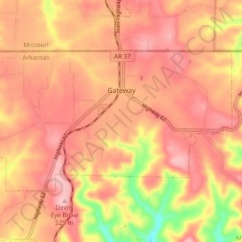
Name: Gateway topographic map, elevation, terrain.

Location: Gateway, Benton County, Arkansas, 72733, United States (36.46828 -93.96748 36.49891 -93.90183)

Average elevation: 1,532 ft

Minimum elevation: 1,142 ft

Maximum elevation: 1,719 ft

Benton County trails, hiking, mountain biking, running and outdoor activities

Other topographic maps

Click on a map to view its topography, its elevation and its terrain.

Hiwasse

United States > Arkansas > Benton County > Gravette

Average elevation: 1,293 ft

Maysville

United States > Arkansas > Benton County

Average elevation: 1,060 ft

Prairie Creek

United States > Arkansas > Benton County > Rogers

Average elevation: 1,276 ft

Dug Hill

United States > Arkansas > Benton County > Bella Vista

Average elevation: 1,129 ft

Loch Lomond

United States > Arkansas > Benton County > Bella Vista

Average elevation: 1,181 ft

Lake Windsor

United States > Arkansas > Benton County > Bella Vista

Average elevation: 1,155 ft

Rago

United States > Arkansas > Benton County > Bella Vista

Average elevation: 1,240 ft

Lake Avalon

United States > Arkansas > Benton County > Bella Vista

Average elevation: 1,158 ft

Lost Bridge Village

United States > Arkansas > Benton County

Average elevation: 1,237 ft

Garfield

United States > Arkansas > Benton County > Garfield

Average elevation: 1,486 ft

Lake Springdale

United States > Arkansas > Benton County > Springdale

Average elevation: 1,286 ft

Oak Grove

United States > Arkansas > Benton County > Oak Grove

Average elevation: 1,188 ft

Healing Springs

United States > Arkansas > Benton County

Average elevation: 1,198 ft

Silent Grove

United States > Arkansas > Benton County > Springdale

Average elevation: 1,293 ft

Pedro

United States > Arkansas > Benton County

Average elevation: 1,096 ft

Gear up for your next adventure:

🧭Map Reading Tools - Tools and kits for map navigation
🏔️Mountain Trail Maps - High‑detail maps for popular peaks
🔦Compact Flashlight - Reliable flashlight for emergencies
🧭Hiking Compass - Precision compass for reliable navigation in the wilderness
🏫Relief Map Kits - Hands-on tools for teaching landforms and elevation

As an Amazon Associate, this site earns from qualifying purchases at no extra cost to you.