Geolocate

Pedro topographic map

Click on the map to display elevation.

About this map

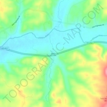
Name: Pedro topographic map, elevation, terrain.

Location: Pedro, Benton County, Arkansas, United States (36.14841 -94.42410 36.18841 -94.38410)

Average elevation: 1,096 ft

Minimum elevation: 968 ft

Maximum elevation: 1,329 ft

Benton County trails, hiking, mountain biking, running and outdoor activities

Other topographic maps

Click on a map to view its topography, its elevation and its terrain.

Springtown

United States > Arkansas > Benton County

Average elevation: 1,273 ft

Little Flock

United States > Arkansas > Benton County

Average elevation: 1,273 ft

Gateway

United States > Arkansas > Benton County

Average elevation: 1,532 ft

Decatur

United States > Arkansas > Benton County

Average elevation: 1,243 ft

Avoca

United States > Arkansas > Benton County

Average elevation: 1,319 ft

Prairie Creek

United States > Arkansas > Benton County > Rogers

Average elevation: 1,276 ft

Bethel Heights

United States > Arkansas > Benton County

Average elevation: 1,365 ft

Beaver Lake

United States > Arkansas > Benton County > Goshen

Beaver Dam was authorized by the Flood Control Act of 1944 and other following acts. The United States Army Corps of Engineers constructed Beaver Dam during the years 1960-1966, impounding a major part of the White River and creating Beaver Lake and flooding much of the valley including the remains of the…

Average elevation: 1,286 ft

Loch Lomond

United States > Arkansas > Benton County > Bella Vista

Average elevation: 1,181 ft

Lake Windsor

United States > Arkansas > Benton County > Bella Vista

Average elevation: 1,155 ft

Lake Avalon

United States > Arkansas > Benton County > Bella Vista

Average elevation: 1,158 ft

Garfield

United States > Arkansas > Benton County > Garfield

Average elevation: 1,486 ft

Sulphur Springs

United States > Arkansas > Benton County

Average elevation: 1,010 ft

Lake Springdale

United States > Arkansas > Benton County > Springdale

Average elevation: 1,286 ft

Gear up for your next adventure:

🛰️Handheld GPS Units - Professional satellite navigators for precise backcountry mapping
🔪Outdoor Multitools - Essential survival tools for gear repair and field use
🛡️Bear Spray Outdoor - Protection in bear country hikes
🔭Stargazing Telescopes - Perfect for camping in low-light pollution areas shown on maps
🏥Hiking First Aid Kits - Comprehensive medical kits for remote trail injuries

As an Amazon Associate, this site earns from qualifying purchases at no extra cost to you.