
Make a donation
Gear up for your next adventure:
As an Amazon Associate, this site earns from qualifying purchases at no extra cost to you.
Little Zab River topographic map
Click on the map to display elevation.
Make a donation
Gear up for your next adventure:
As an Amazon Associate, this site earns from qualifying purchases at no extra cost to you.
Little Zab River
The Little Zab rises in the Zagros Mountains in Iran at an elevation of circa 3,000 metres (9,800 ft) amsl. In its upper reaches, the course of the Little Zab is determined by the alignment of the major mountain chains that make up the Zagros. Thus, the river flows through valleys that are predominantly aligned along a northwest–southeast axis, parallel to the major mountain chains of the Zagros, only to change its direction abruptly where it cuts through these chains in narrow gorges. Along the way, it collects the waters coming down from the eastern face of the Qandil Mountains, which now form the border between Iran and Iraq. The Little Zab enters the Mesopotamian plain south of Dukan, where it first assumes a roughly westward course before turning to the southwest upstream from the town of Altun Kopru and uniting with the Tigris near the town of Al Zab. Most tributaries join the Little Zab upstream from Dukan, with the largest being the Baneh River and the Qala Chulan. A number of smaller streams joined the Little Zab in the Ranya Plain, which is now partly inundated by Lake Dukan.
Make a donation
Gear up for your next adventure:
As an Amazon Associate, this site earns from qualifying purchases at no extra cost to you.
About this map
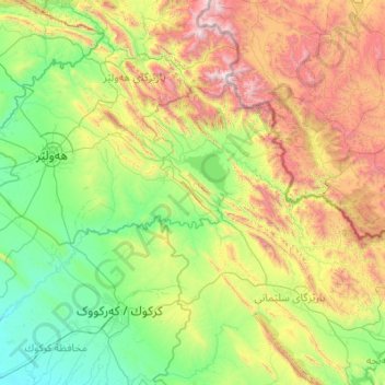
Name: Little Zab River topographic map, elevation, terrain.
Location: Little Zab River, Iraqi Kurdistan Region, Iraq (35.23639 43.42735 36.78356 45.61858)
Average elevation: 3,094 ft
Minimum elevation: 564 ft
Maximum elevation: 11,699 ft
Make a donation
Gear up for your next adventure:
As an Amazon Associate, this site earns from qualifying purchases at no extra cost to you.
Other topographic maps
Click on a map to view its topography, its elevation and its terrain.
Make a donation
Gear up for your next adventure:
As an Amazon Associate, this site earns from qualifying purchases at no extra cost to you.
Make a donation
Gear up for your next adventure:
As an Amazon Associate, this site earns from qualifying purchases at no extra cost to you.
Make a donation
Gear up for your next adventure:
As an Amazon Associate, this site earns from qualifying purchases at no extra cost to you.
Make a donation
Gear up for your next adventure:
As an Amazon Associate, this site earns from qualifying purchases at no extra cost to you.
Nimrud
Iraq > Nineveh Governorate > Qaryat an Namaniyah
Subsequent work was by the Directorate of Antiquities of the Republic of Iraq (1956, 1959–60, 1969–78 and 1982–92), the Polish Centre of Mediterranean Archaeology University of Warsaw directed by Janusz Meuszyński (1974–76), Paolo Fiorina (1987–89) with the Centro Ricerche Archeologiche e Scavi di…
Average elevation: 666 ft
Make a donation
Gear up for your next adventure:
As an Amazon Associate, this site earns from qualifying purchases at no extra cost to you.
Make a donation
Gear up for your next adventure:
As an Amazon Associate, this site earns from qualifying purchases at no extra cost to you.
Make a donation
Gear up for your next adventure:
As an Amazon Associate, this site earns from qualifying purchases at no extra cost to you.
Make a donation
Gear up for your next adventure:
As an Amazon Associate, this site earns from qualifying purchases at no extra cost to you.
Make a donation
Gear up for your next adventure:
As an Amazon Associate, this site earns from qualifying purchases at no extra cost to you.
Make a donation
Gear up for your next adventure:
As an Amazon Associate, this site earns from qualifying purchases at no extra cost to you.
Babylon
Iraq > Babil Governorate > Qaryat Annan
A topographical survey at the site was conducted in 1974, followed in 1977 by a review of the stratigraphical position of the main monuments and reconsideration of ancient water levels, by the Turin Centre for Archaeological Research and Excavations in the Middle East and Asia, and the Iraqi-Italian Institute…
Average elevation: 105 ft
Make a donation
Gear up for your next adventure:
As an Amazon Associate, this site earns from qualifying purchases at no extra cost to you.
Make a donation
Gear up for your next adventure:
As an Amazon Associate, this site earns from qualifying purchases at no extra cost to you.
Make a donation
Gear up for your next adventure:
As an Amazon Associate, this site earns from qualifying purchases at no extra cost to you.
Make a donation
Gear up for your next adventure:
As an Amazon Associate, this site earns from qualifying purchases at no extra cost to you.
Make a donation
Gear up for your next adventure:
As an Amazon Associate, this site earns from qualifying purchases at no extra cost to you.
Make a donation
Gear up for your next adventure:
As an Amazon Associate, this site earns from qualifying purchases at no extra cost to you.
Make a donation
Gear up for your next adventure:
As an Amazon Associate, this site earns from qualifying purchases at no extra cost to you.
Make a donation
Gear up for your next adventure:
As an Amazon Associate, this site earns from qualifying purchases at no extra cost to you.
Make a donation
Gear up for your next adventure:
As an Amazon Associate, this site earns from qualifying purchases at no extra cost to you.
Make a donation
Gear up for your next adventure:
As an Amazon Associate, this site earns from qualifying purchases at no extra cost to you.