Geolocate

Country Club topographic map

Click on the map to display elevation.

About this map

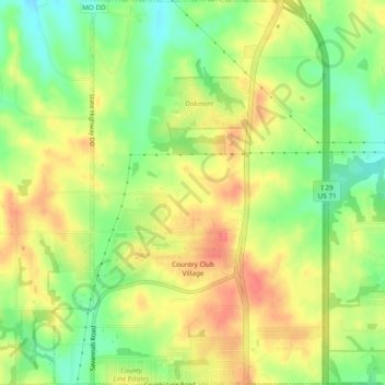
Name: Country Club topographic map, elevation, terrain.

Location: Country Club, Andrew County, Missouri, United States (39.82112 -94.83897 39.85772 -94.80541)

Average elevation: 1,010 ft

Minimum elevation: 912 ft

Maximum elevation: 1,099 ft

Andrew County trails, hiking, mountain biking, running and outdoor activities

Other topographic maps

Click on a map to view its topography, its elevation and its terrain.

Riggin Branch

United States > Missouri > Andrew County

Average elevation: 945 ft

Empire Prairie

United States > Missouri > Andrew County

Average elevation: 1,076 ft

Avenue City

United States > Missouri > Andrew County

Average elevation: 925 ft

Flag Springs

United States > Missouri > Andrew County

Average elevation: 1,030 ft

Fountainbleau

United States > Missouri > Andrew County

Average elevation: 981 ft

Kodiak

United States > Missouri > Andrew County

Average elevation: 994 ft

Nodaway

United States > Missouri > Andrew County

Average elevation: 892 ft

Rankin

United States > Missouri > Andrew County

Average elevation: 988 ft

Rochester

United States > Missouri > Andrew County

Average elevation: 945 ft

Whitesville

United States > Missouri > Andrew County

Average elevation: 961 ft

Wyeth

United States > Missouri > Andrew County

Average elevation: 958 ft

Gear up for your next adventure:

🔌USB Car Charger - Car charger for on‑the‑go power needs
🪵Folding Camp Saw - Compact saw for wood and campsite work
🛌Ultralight Sleeping Bags - Compact down bags for cold nights in the wilderness
🎒Day Hiking Backpack - Lightweight backpack perfect for day trips and outdoor adventures
🪶Fire Starter Kit - Reliable fire starter for survival and camping

As an Amazon Associate, this site earns from qualifying purchases at no extra cost to you.