Geolocate

Wyeth topographic map

Click on the map to display elevation.

About this map

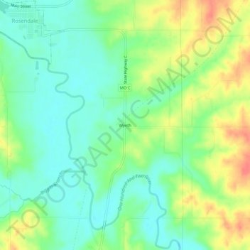
Name: Wyeth topographic map, elevation, terrain.

Location: Wyeth, Andrew County, Missouri, 64483, United States (40.00499 -94.82219 40.04499 -94.78219)

Average elevation: 958 ft

Minimum elevation: 889 ft

Maximum elevation: 1,066 ft

Andrew County trails, hiking, mountain biking, running and outdoor activities

Other topographic maps

Click on a map to view its topography, its elevation and its terrain.

Riggin Branch

United States > Missouri > Andrew County

Average elevation: 945 ft

Bolckow

United States > Missouri > Andrew County

Average elevation: 958 ft

Fillmore

United States > Missouri > Andrew County

Average elevation: 938 ft

Rea

United States > Missouri > Andrew County

Average elevation: 1,037 ft

Rosendale

United States > Missouri > Andrew County

Average elevation: 945 ft

Amazonia

United States > Missouri > Andrew County

Average elevation: 902 ft

Cosby

United States > Missouri > Andrew County

Average elevation: 932 ft

Country Club

United States > Missouri > Andrew County

Average elevation: 1,010 ft

Gear up for your next adventure:

🌎3D Topographic Globes - Raised relief globes for a tactile understanding of geography
📡Handheld GPS Device - Reliable handheld GPS for outdoor navigation
📚USA Hiking Guide Books - Top trail guides and map books
🚑Emergency Bivvies - Heat-reflective sleeping bags for survival situations
🖼️Topo Map Wall Art - Decorative topographic prints of famous peaks and regions

As an Amazon Associate, this site earns from qualifying purchases at no extra cost to you.