Geolocate

Rankin topographic map

Click on the map to display elevation.

About this map

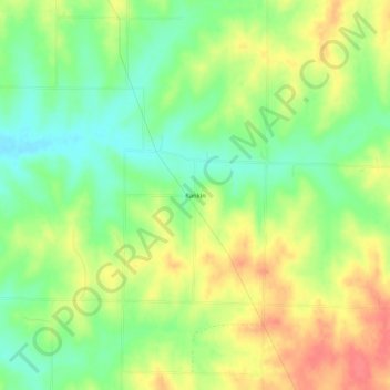
Name: Rankin topographic map, elevation, terrain.

Location: Rankin, Andrew County, Missouri, United States (40.04722 -94.93775 40.08722 -94.89775)

Average elevation: 988 ft

Minimum elevation: 889 ft

Maximum elevation: 1,099 ft

Andrew County trails, hiking, mountain biking, running and outdoor activities

Other topographic maps

Click on a map to view its topography, its elevation and its terrain.

Riggin Branch

United States > Missouri > Andrew County

Average elevation: 945 ft

Bolckow

United States > Missouri > Andrew County

Average elevation: 958 ft

Fillmore

United States > Missouri > Andrew County

Average elevation: 938 ft

Rea

United States > Missouri > Andrew County

Average elevation: 1,037 ft

Rosendale

United States > Missouri > Andrew County

Average elevation: 945 ft

Amazonia

United States > Missouri > Andrew County

Average elevation: 902 ft

Cosby

United States > Missouri > Andrew County

Average elevation: 932 ft

Country Club

United States > Missouri > Andrew County

Average elevation: 1,010 ft

Gear up for your next adventure:

🧺Microfiber Travel Towels - Compact and fast-drying towels for trail use
🔌USB Car Charger - Car charger for on‑the‑go power needs
🎒Trekking Poles - Sturdy poles for balance and stability on rough terrain
🌎3D Topographic Globes - Raised relief globes for a tactile understanding of geography
🎒Waterproof Dry Bags - Keep your electronics and maps dry inside your pack

As an Amazon Associate, this site earns from qualifying purchases at no extra cost to you.