
Make a donation
Gear up for your next adventure:
As an Amazon Associate, this site earns from qualifying purchases at no extra cost to you.
Guardiagrele topographic map
Click on the map to display elevation.
Make a donation
Gear up for your next adventure:
As an Amazon Associate, this site earns from qualifying purchases at no extra cost to you.
Guardiagrele
Guardiagrele (Italian pronunciation: [ɡuardiaˈɡreːle]; Abruzzese: La 'Uàrdije; Latin: Guardia Graelis) is a town and comune in the province of Chieti, part of the Abruzzo region of central Italy. It is in the foothills of the Maiella mountain at an elevation of around 576 metres (1,890 ft). Its population numbers about 10,000.
Make a donation
Gear up for your next adventure:
As an Amazon Associate, this site earns from qualifying purchases at no extra cost to you.
About this map
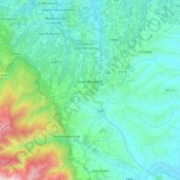
Name: Guardiagrele topographic map, elevation, terrain.
Location: Guardiagrele, Chieti, Abruzzo, 66016, Italy (42.14798 14.13535 42.22899 14.32673)
Average elevation: 1,752 ft
Minimum elevation: 413 ft
Maximum elevation: 7,572 ft
Make a donation
Gear up for your next adventure:
As an Amazon Associate, this site earns from qualifying purchases at no extra cost to you.
Other topographic maps
Click on a map to view its topography, its elevation and its terrain.
Make a donation
Gear up for your next adventure:
As an Amazon Associate, this site earns from qualifying purchases at no extra cost to you.
Make a donation
Gear up for your next adventure:
As an Amazon Associate, this site earns from qualifying purchases at no extra cost to you.