
Make a donation
Gear up for your next adventure:
As an Amazon Associate, this site earns from qualifying purchases at no extra cost to you.
Huasca de Ocampo topographic map
Click on the map to display elevation.
Make a donation
Gear up for your next adventure:
As an Amazon Associate, this site earns from qualifying purchases at no extra cost to you.
Huasca de Ocampo
The municipality extends from the Sierra de Pachuca mountains, where the town is, to over part of a wide, flat valley with lower altitude and warmer temperatures. This area is filled with small towns and villages, as well as fields and orchards. The higher elevations around these flat lands are forested with holm oak which give them an ashy-green look. The altitude of the municipality varies from between 1,800 and 2,800 masl. The municipality is part of the Reserva de la Biosfera de la Vega de Meztitlán (Vega de Meztitlán Biosphere Reserve). About 70% of the municipality lies on the Trans-Mexican Volcanic Belt although there are no active volcanoes here.
Make a donation
Gear up for your next adventure:
As an Amazon Associate, this site earns from qualifying purchases at no extra cost to you.
About this map
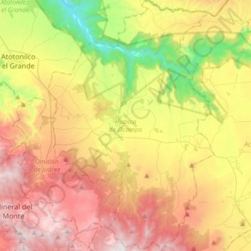
Name: Huasca de Ocampo topographic map, elevation, terrain.
Location: Huasca de Ocampo, Hidalgo, Mexico (20.09931 -98.63741 20.34703 -98.46145)
Average elevation: 7,244 ft
Minimum elevation: 4,672 ft
Maximum elevation: 10,049 ft
Make a donation
Gear up for your next adventure:
As an Amazon Associate, this site earns from qualifying purchases at no extra cost to you.
Other topographic maps
Click on a map to view its topography, its elevation and its terrain.
Make a donation
Gear up for your next adventure:
As an Amazon Associate, this site earns from qualifying purchases at no extra cost to you.
Make a donation
Gear up for your next adventure:
As an Amazon Associate, this site earns from qualifying purchases at no extra cost to you.
Make a donation
Gear up for your next adventure:
As an Amazon Associate, this site earns from qualifying purchases at no extra cost to you.
Make a donation
Gear up for your next adventure:
As an Amazon Associate, this site earns from qualifying purchases at no extra cost to you.
Make a donation
Gear up for your next adventure:
As an Amazon Associate, this site earns from qualifying purchases at no extra cost to you.