
Make a donation
Gear up for your next adventure:
As an Amazon Associate, this site earns from qualifying purchases at no extra cost to you.
Enfield topographic map
Click on the map to display elevation.
Make a donation
Gear up for your next adventure:
As an Amazon Associate, this site earns from qualifying purchases at no extra cost to you.
Enfield
According to the United States Census Bureau, the town has a total area of 43.1 square miles (111.6 km2), of which 40.3 sq mi (104.3 km2) is land and 2.9 sq mi (7.4 km2) is water, comprising 6.59% of the town. Enfield is drained by the Mascoma River. Mascoma Lake, in the west, represents Enfield's lowest elevation at 751 feet (229 m) above sea level. The highest elevation is over 2,100 ft (640 m) at the summit of Prospect Hill, overlooking Halfmile Pond. Crystal Lake is in the east. Enfield lies fully within the Connecticut River watershed.
Make a donation
Gear up for your next adventure:
As an Amazon Associate, this site earns from qualifying purchases at no extra cost to you.
About this map
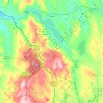
Name: Enfield topographic map, elevation, terrain.
Location: Enfield, Grafton County, New Hampshire, United States (43.52894 -72.20815 43.65909 -72.02010)
Average elevation: 1,201 ft
Minimum elevation: 584 ft
Maximum elevation: 2,146 ft
Grafton County trails, hiking, mountain biking, running and outdoor activities
Make a donation
Gear up for your next adventure:
As an Amazon Associate, this site earns from qualifying purchases at no extra cost to you.
Other topographic maps
Click on a map to view its topography, its elevation and its terrain.
Stinson Lake
United States > New Hampshire > Grafton County > Rumney > Stinson Lake
Average elevation: 1,509 ft
Make a donation
Gear up for your next adventure:
As an Amazon Associate, this site earns from qualifying purchases at no extra cost to you.
Make a donation
Gear up for your next adventure:
As an Amazon Associate, this site earns from qualifying purchases at no extra cost to you.
Middle Sugarloaf
United States > New Hampshire > Grafton County > Bethlehem
Average elevation: 1,942 ft
Make a donation
Gear up for your next adventure:
As an Amazon Associate, this site earns from qualifying purchases at no extra cost to you.
Campton Hollow
United States > New Hampshire > Grafton County > Campton > Campton Hollow
Average elevation: 823 ft
Make a donation
Gear up for your next adventure:
As an Amazon Associate, this site earns from qualifying purchases at no extra cost to you.
Corcoran Pond
United States > New Hampshire > Grafton County > Waterville Valley
Average elevation: 1,713 ft
Waterville Valley
United States > New Hampshire > Grafton County > Waterville Valley > Waterville Valley
Average elevation: 1,860 ft
Make a donation
Gear up for your next adventure:
As an Amazon Associate, this site earns from qualifying purchases at no extra cost to you.
Downing Mountain
United States > New Hampshire > Grafton County > Ellsworth
Average elevation: 1,460 ft
Make a donation
Gear up for your next adventure:
As an Amazon Associate, this site earns from qualifying purchases at no extra cost to you.
Campton Lower Village
United States > New Hampshire > Grafton County > Campton
Average elevation: 853 ft
Make a donation
Gear up for your next adventure:
As an Amazon Associate, this site earns from qualifying purchases at no extra cost to you.
Mount Pemigewasset
United States > New Hampshire > Grafton County > Lincoln
Average elevation: 1,995 ft
Make a donation
Gear up for your next adventure:
As an Amazon Associate, this site earns from qualifying purchases at no extra cost to you.
Woodstock
United States > New Hampshire > Grafton County > Woodstock > Woodstock
Average elevation: 1,093 ft
Make a donation
Gear up for your next adventure:
As an Amazon Associate, this site earns from qualifying purchases at no extra cost to you.