
Harvard topographic map
Click on the map to display elevation.
Harvard
The eastern part of Harvard is on a large ridgeline. In 1931 Harvard College established the Oak Ridge Observatory at an elevation of 609 feet on Pinnacle Rd, the highest point between Mount Wachusett and the ocean.
About this map
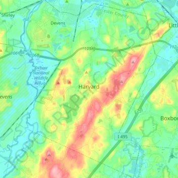
Name: Harvard topographic map, elevation, terrain.
Location: Harvard, Worcester County, Massachusetts, United States (42.44732 -71.63921 42.55250 -71.52984)
Average elevation: 328 ft
Minimum elevation: 200 ft
Maximum elevation: 636 ft
Worcester County trails, hiking, mountain biking, running and outdoor activities
Other topographic maps
Click on a map to view its topography, its elevation and its terrain.
Gates Crossing
United States > Massachusetts > Worcester County > Leominster
Average elevation: 407 ft
Wachusett Station
United States > Massachusetts > Worcester County > Fitchburg
Average elevation: 751 ft
Central (Stanley) Woolen Mill District Park
United States > Massachusetts > Worcester County > Uxbridge
Average elevation: 262 ft
Crow Hill Ledges
United States > Massachusetts > Worcester County > Westminster
Average elevation: 961 ft
Olde English Village
United States > Massachusetts > Worcester County > Gardner
Average elevation: 1,010 ft
Vernon Hill
United States > Massachusetts > Worcester County > Worcester > Quinsigamond Village
Average elevation: 531 ft
Royalston Falls
United States > Massachusetts > Worcester County > Royalston
Average elevation: 994 ft
South Charlton Reservoir
United States > Massachusetts > Worcester County > Charlton > South Charlton
Average elevation: 666 ft
Tatnuck
United States > Massachusetts > Worcester County > Worcester > Tatnuck Square
Average elevation: 725 ft
Blackburn Village
United States > Massachusetts > Worcester County > Ashburnham
Average elevation: 1,070 ft
Bassets Corner
United States > Massachusetts > Worcester County > Petersham
Average elevation: 1,063 ft
Hadwen Park
United States > Massachusetts > Worcester County > Worcester > Heard Street
Average elevation: 545 ft
Institute Park
United States > Massachusetts > Worcester County > Worcester > Belmont Hill
Average elevation: 558 ft
Thompsons Pond Dam
United States > Massachusetts > Worcester County > Spencer
Average elevation: 912 ft
Phillipston Four Corners
United States > Massachusetts > Worcester County > Phillipston
Average elevation: 1,099 ft
South Royalston
United States > Massachusetts > Worcester County > Royalston
Average elevation: 942 ft
Northbridge Center
United States > Massachusetts > Worcester County > Northbridge
Average elevation: 407 ft
Plummers Hill
United States > Massachusetts > Worcester County > Northbridge
Average elevation: 335 ft
West Upton
United States > Massachusetts > Worcester County > Upton > West Upton
Average elevation: 364 ft
Jefferson
United States > Massachusetts > Worcester County > Holden > Jefferson
Average elevation: 814 ft
Hammond Heights
United States > Massachusetts > Worcester County > Worcester
Average elevation: 568 ft
Summit
United States > Massachusetts > Worcester County > Worcester > Summit
Average elevation: 653 ft
North Worcester
United States > Massachusetts > Worcester County > Worcester
Average elevation: 709 ft