
Make a donation
Gear up for your next adventure:
As an Amazon Associate, this site earns from qualifying purchases at no extra cost to you.
Hillsborough topographic map
Click on the map to display elevation.
Make a donation
Gear up for your next adventure:
As an Amazon Associate, this site earns from qualifying purchases at no extra cost to you.
Hillsborough
According to the United States Census Bureau, the town has a total area of 6.2 square miles (16 km2), all of it land. The area's considerably winding, hilly topography, and impossibility of a grid layout make Hillsborough notoriously challenging to navigate. Many lots include fairly steep slopes, particularly the western side of the town, with the landscape generally flattening to the east as it descends from the 280 freeway to El Camino Real and the towns of Burlingame and San Mateo.
Make a donation
Gear up for your next adventure:
As an Amazon Associate, this site earns from qualifying purchases at no extra cost to you.
About this map
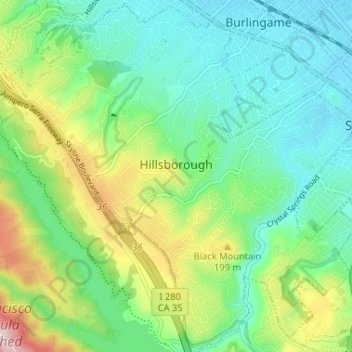
Name: Hillsborough topographic map, elevation, terrain.
Location: Hillsborough, San Mateo County, California, United States (37.53005 -122.39343 37.58085 -122.32838)
Average elevation: 328 ft
Minimum elevation: 10 ft
Maximum elevation: 1,086 ft
San Mateo County trails, hiking, mountain biking, running and outdoor activities
Make a donation
Gear up for your next adventure:
As an Amazon Associate, this site earns from qualifying purchases at no extra cost to you.
Other topographic maps
Click on a map to view its topography, its elevation and its terrain.
Red Morton Community Park
United States > California > San Mateo County > Redwood City
Average elevation: 59 ft
Bayshore Heights Park
United States > California > San Mateo County > Daly City
Average elevation: 276 ft
Make a donation
Gear up for your next adventure:
As an Amazon Associate, this site earns from qualifying purchases at no extra cost to you.
Redwood Junction
United States > California > San Mateo County > Redwood City
Average elevation: 30 ft
Make a donation
Gear up for your next adventure:
As an Amazon Associate, this site earns from qualifying purchases at no extra cost to you.
Hillsborough Park
United States > California > San Mateo County > Hillsborough
Average elevation: 325 ft
Make a donation
Gear up for your next adventure:
As an Amazon Associate, this site earns from qualifying purchases at no extra cost to you.
Make a donation
Gear up for your next adventure:
As an Amazon Associate, this site earns from qualifying purchases at no extra cost to you.
Redwood Junction
United States > California > San Mateo County > Redwood City
Average elevation: 30 ft
Make a donation
Gear up for your next adventure:
As an Amazon Associate, this site earns from qualifying purchases at no extra cost to you.
Make a donation
Gear up for your next adventure:
As an Amazon Associate, this site earns from qualifying purchases at no extra cost to you.
Make a donation
Gear up for your next adventure:
As an Amazon Associate, this site earns from qualifying purchases at no extra cost to you.
Hillsborough Park
United States > California > San Mateo County > Hillsborough
Average elevation: 325 ft
Half Moon Bay
United States > California > San Mateo County > Half Moon Bay > Half Moon Bay
Average elevation: 240 ft
Brisbane
United States > California > San Mateo County > Brisbane > Brisbane
Average elevation: 167 ft
Make a donation
Gear up for your next adventure:
As an Amazon Associate, this site earns from qualifying purchases at no extra cost to you.
Daly City
United States > California > San Mateo County > Daly City
Several golf courses are located within or straddle the border with San Francisco. The Olympic Club has hosted the USGA U.S. Open five times, most recently in 2012, and will host both the 2028 PGA Championship and the 2032 Ryder Cup. The private San Francisco Golf Club and Lake Merced Golf Club have part or…
Average elevation: 105 ft
San Carlos
United States > California > San Mateo County > San Carlos > San Carlos
Average elevation: 154 ft
Make a donation
Gear up for your next adventure:
As an Amazon Associate, this site earns from qualifying purchases at no extra cost to you.
Highlands
United States > California > San Mateo County > San Mateo Highlands
Average elevation: 423 ft