
Austin topographic map
Click on the map to display elevation.
Austin
Austin features a diverse and varied topography shaped by its position along the Balcones Fault. The city’s elevation ranges from about 425 feet to approximately 1,000 feet above sea level, creating a landscape characterized by rolling hills and elevated areas particularly in the western regions. To the east, the terrain transitions into flatter, more level ground with heavy clay and loam soils typical of the Blackland Prairie. This elevation difference contributes to a variety of natural features, including limestone outcrops and scenic vistas, especially around the Hill Country, which enhances both the ecological diversity and the recreational opportunities available in the area. The combination of hilly terrain and flatlands creates a striking contrast that defines the physical geography of Austin and its surroundings.
About this map
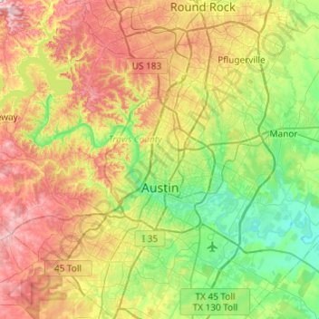
Name: Austin topographic map, elevation, terrain.
Location: Austin, Travis County, Texas, United States (30.09851 -97.93677 30.51663 -97.56053)
Average elevation: 709 ft
Minimum elevation: 371 ft
Maximum elevation: 1,266 ft
Travis County trails, hiking, mountain biking, running and outdoor activities
Other topographic maps
Click on a map to view its topography, its elevation and its terrain.
Roy G. Guerrero Colorado River Metro Park
United States > Texas > Travis County > Austin
Average elevation: 463 ft
Austin
United States > Texas > Travis County > Austin
The elevation of Austin varies from 425 feet (130 m) to approximately 1,000 feet (305 m) above sea level. Due to the fact it straddles the Balcones Fault, much of the eastern part of the city is flat, with heavy clay and loam soils, whereas the western part and western suburbs consist of rolling hills on the…
Average elevation: 666 ft
Pflugerville
United States > Texas > Travis County > Pflugerville > Pflugerville
Average elevation: 719 ft