Geolocate

Mount Evans topographic map

Click on the map to display elevation.

About this map

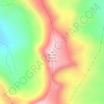
Name: Mount Evans topographic map, elevation, terrain.

Location: Mount Evans, Lake County, Colorado, United States (39.25688 -106.18174 39.25698 -106.18164)

Average elevation: 12,559 ft

Minimum elevation: 11,598 ft

Maximum elevation: 13,596 ft

Lake County trails, hiking, mountain biking, running and outdoor activities

Other topographic maps

Click on a map to view its topography, its elevation and its terrain.

Leadville

United States > Colorado > Lake County

Average elevation: 10,190 ft

Lily Lake

United States > Colorado > Lake County

Average elevation: 10,676 ft

Crystal Lakes

United States > Colorado > Lake County

Average elevation: 9,511 ft

Leadville North

United States > Colorado > Lake County > Leadville

Average elevation: 9,974 ft

Lake Creek

United States > Colorado > Lake County

Average elevation: 10,804 ft

Hagerman Lake

United States > Colorado > Lake County

Average elevation: 11,430 ft

Lake Isabelle

United States > Colorado > Lake County

Average elevation: 11,811 ft

Gear up for your next adventure:

Camping Coffee Makers - Enjoy premium coffee at the summit or campsite
🗺️NatGeo Topo Maps - High-quality waterproof printed topographic maps of US Parks
🧭Pro Hiking Compasses - High-accuracy liquid-filled compasses for topographic orientation
📚USA Hiking Guide Books - Top trail guides and map books
🌡️Handheld Weather Meters - Measure wind, temp, and pressure for safe mountain travel

As an Amazon Associate, this site earns from qualifying purchases at no extra cost to you.