
Make a donation
Gear up for your next adventure:
As an Amazon Associate, this site earns from qualifying purchases at no extra cost to you.
Cráter de Chicxulub topographic map
Click on the map to display elevation.
Make a donation
Gear up for your next adventure:
As an Amazon Associate, this site earns from qualifying purchases at no extra cost to you.
About this map
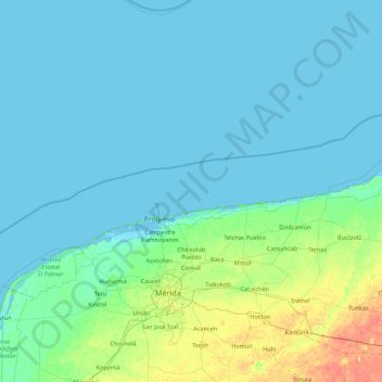
Name: Cráter de Chicxulub topographic map, elevation, terrain.
Location: Cráter de Chicxulub, Mexico (20.58387 -90.39090 22.21155 -88.64265)
Average elevation: 13 ft
Minimum elevation: -13 ft
Maximum elevation: 102 ft
Make a donation
Gear up for your next adventure:
As an Amazon Associate, this site earns from qualifying purchases at no extra cost to you.
Other topographic maps
Click on a map to view its topography, its elevation and its terrain.
Mexico City
Mexico City is situated in the Valley of Mexico, an expansive highland region characterized by a unique and varied topography. The city itself rests at an elevation of approximately 7,350 feet (2,240 meters) above sea level, surrounded by formidable mountain ranges, including the Sierra de Guadalupe to the…
Average elevation: 8,593 ft
Tijuana
Mexico > Baja California > Municipio de Tijuana
Housing development in the Tijuana Hills has led to eradication of many seasonal mountain streams. This lack of natural drainage makes places within the city vulnerable to landslides during the rainy season. The varied terrain of Tijuana gives the city elevation extremes that range from sea level to 790 meters…
Average elevation: 463 ft
Oaxaca
The state is located in the south of Mexico, bordered by the states of Puebla, Veracruz, Chiapas and Guerrero with the Pacific Ocean to the south. It has a territory of 93,967 km2 (36,281 sq mi), accounting for less than 5% of Mexico's territory. Here several mountain chains come together, with the elevation…
Average elevation: 2,343 ft
Baja California
Baja California is the 12th-largest state by area in Mexico. Its geography ranges from beaches to forests and deserts. The backbone of the state is the Sierra de Baja California, where Picacho del Diablo, the highest point of the peninsula, is located. This mountain range effectively divides the weather…
Average elevation: 587 ft
Make a donation
Gear up for your next adventure:
As an Amazon Associate, this site earns from qualifying purchases at no extra cost to you.
Guanajuato
Guanajuato is in the center of Mexico, northwest of Mexico City, bordering Zacatecas, San Luis Potosí, Michoacán, Querétaro, and Jalisco. It is the 20th-largest of Mexico's states, with an area of 30,589 km². It has an average altitude of 2,015 meters (6,611 ft) above sea level, with its territory divided…
Average elevation: 6,578 ft
Guadalajara
Mexico > Jalisco > Guadalajara
Under the Köppen climate classification, Guadalajara has a humid subtropical climate (Cwa), a temperate climate that is quite close to a tropical climate, featuring dry warm winters and wet, mildly hot summers. Guadalajara's climate is influenced by its high altitude and the general seasonality of…
Average elevation: 5,157 ft
Monterrey
Mexico > Nuevo León > Monterrey
The city of Monterrey is 540 metres (1,770 ft) above sea level in the northeastern state of Nuevo León. Monterrey translated literally from Spanish to English is "King Mount" or "King Mountain", and folk etymology claims that this refers to the city's topography and the large mountains that surround it…
Average elevation: 2,470 ft
Nuevo León
Nuevo León's geography is known for englobing three of the most important physiographic provinces of the northeast region. The south end of the Great Plains is considered to start in the northernmost regions of Nuevo León. The region is characterized by the soft hills that dominates the lands neighboring the…
Average elevation: 2,641 ft
Make a donation
Gear up for your next adventure:
As an Amazon Associate, this site earns from qualifying purchases at no extra cost to you.
Baja California
Baja California is the 12th-largest state by area in Mexico. Its geography ranges from beaches to forests and deserts. The backbone of the state is the Sierra de Baja California, where Picacho del Diablo, the highest point of the peninsula, is located. This mountain range effectively divides the weather…
Average elevation: 587 ft
La Paz
Mexico > Baja California Sur > Municipio de La Paz
The city, in west-central Bolivia 68 km (42 mi) southeast of Lake Titicaca, is set in a canyon created by the Choqueyapu River. It is in a bowl-like depression, part of the Amazon basin, surrounded by the high mountains of the Altiplano. Overlooking the city is the towering, triple-peaked Illimani. Its peaks…
Average elevation: 374 ft
Make a donation
Gear up for your next adventure:
As an Amazon Associate, this site earns from qualifying purchases at no extra cost to you.
Mérida
Mérida is located in the northwest part of the state of Yucatán, which occupies the northern portion of the Yucatán Peninsula. To the east is the state of Quintana Roo, to the west is the state of Campeche, to the north is the Gulf of Mexico, and far to the south is the state of Chiapas. The city is also…
Average elevation: 30 ft
Chihuahua
The main mountain range in the state is the Sierra Madre Occidental reaching a maximum altitude of 10,826 ft (3,300 m) known as Cerro Mohinora. Mountains account for one third of the state's surface area which include large coniferous forests. The climate in the mountainous regions varies. Chihuahua has more…
Average elevation: 4,583 ft
Oaxaca
The state is located in the south of Mexico, bordered by the states of Puebla, Veracruz, Chiapas and Guerrero with the Pacific Ocean to the south. It has a territory of 93,967 km2 (36,281 sq mi), accounting for less than 5% of Mexico's territory. Here several mountain chains come together, with the elevation…
Average elevation: 2,343 ft
Chiapas
The Sierra Madre de Chiapas runs parallel to the Pacific coastline of the state, northwest to southeast as a continuation of the Sierra Madre del Sur. This area has the highest altitudes in Chiapas including the Tacaná Volcano, which rises 4,093 m (13,428 ft) above sea level. Most of these mountains are…
Average elevation: 2,116 ft
Make a donation
Gear up for your next adventure:
As an Amazon Associate, this site earns from qualifying purchases at no extra cost to you.
Yucatán
The State of Yucatán is located on the Yucatán Peninsula. It borders the states of Campeche to the southwest, Quintana Roo to the east and southeast, and the Gulf of Mexico to the north and west. As a whole, the state is extremely flat with little or no topographic variation, with the exception of the Puuc…
Average elevation: 52 ft
Mexico City
Mexico > Mexico City > Mexico City
Mexico City is located in the Valley of Mexico, sometimes called the Basin of Mexico. This valley is located in the Trans-Mexican Volcanic Belt in the high plateaus of south-central Mexico. It has a minimum altitude of 2,200 meters (7,200 feet) above sea level and is surrounded by mountains and volcanoes that…
Average elevation: 7,615 ft
Oaxaca
The state is in the south of Mexico, bordered by the states of Puebla, Veracruz, Chiapas and Guerrero, with the Pacific Ocean to the south. It has a territory of 93,967 km2 (36,281 sq mi), accounting for less than 5% of Mexico's territory. Here several mountain chains come together, with the elevation varying…
Average elevation: 2,343 ft
Make a donation
Gear up for your next adventure:
As an Amazon Associate, this site earns from qualifying purchases at no extra cost to you.
Chilpancingo
Mexico > Guerrero > Chilpancingo de los Bravo
The climate of Chilpancingo is classified as a tropical savanna climate ("Aw"). There is some moderation due to high elevation, but high temperatures are still in the upper 20s °C (80s °F) for most of the year.
Average elevation: 5,338 ft
Toluca
Mexico > State of Mexico > Toluca
The Lerma River flows from Lake Almoloya del Río through the center of the municipality towards the west, flowing into Lake Chapala. From this point westward the river takes the name of Río Grande de Santiago. And it goes from this lake to the Pacific Ocean in the state of Nayarit. The river is about 1,180…
Average elevation: 8,953 ft
Michoacán
Much of the climate of the state is determined by altitude and other geographical features. Average temperatures vary from 13 °C (55 °F) to 29 °C (84 °F). Lower temperatures correspond with the highland areas in the north and east while the lower south and west, called La Costa (the coast) or Tierra…
Average elevation: 4,065 ft
Make a donation
Gear up for your next adventure:
As an Amazon Associate, this site earns from qualifying purchases at no extra cost to you.
Querétaro
Three of Mexico’s geographic zones cover parts of the state. The Mesa del Centro is in the center-west of the state, and mostly consists of small mesas with an average altitude of 2,000 meters (6,562 feet) above sea level (ASL). A few elevations reach over 3,000 meters (9,843 feet). The Sierra Madre Oriental…
Average elevation: 6,522 ft
San Luis Potosí City
Mexico > San Luis Potosi > Municipio de San Luis Potosí
San Luis Potosí, commonly called SLP or simply San Luis, is the capital and the most populous city of the Mexican state of San Luis Potosí. It is the municipal seat of the surrounding municipality of San Luis Potosí. The city lies at an elevation of 1,864 metres (6,115 feet). It has an estimated population…
Average elevation: 6,575 ft
Chiapas
The Sierra Madre de Chiapas runs parallel to the Pacific coastline of the state, northwest to southeast as a continuation of the Sierra Madre del Sur. This area has the highest altitudes in Chiapas including the Tacaná Volcano, which rises 4,093 m (13,428 ft) above sea level. Most of these mountains are…
Average elevation: 2,116 ft
Yucatán
The topography of the Yucatán Peninsula is characterized by a largely flat and low-lying terrain, primarily formed from limestone and covered by a thin layer of soil. This flatness is a defining feature, as the peninsula is part of the larger Yucatán Platform, which extends across approximately 70,000 square…
Average elevation: 52 ft
Make a donation
Gear up for your next adventure:
As an Amazon Associate, this site earns from qualifying purchases at no extra cost to you.
Mérida
Mérida is located in the northwest part of the state of Yucatán, which occupies the northern portion of the Yucatán Peninsula. To the east is the state of Quintana Roo, to the west is the state of Campeche, to the north is the Gulf of Mexico, and far to the south is the state of Chiapas. The city is also…
Average elevation: 26 ft
Guanajuato
Guanajuato is in the center of Mexico, northwest of Mexico City, bordering Zacatecas, San Luis Potosí, Michoacán, Querétaro, and Jalisco. It is the 20th-largest of Mexico's states, with an area of 30,589 km². It has an average altitude of 2,015 meters (6,611 ft) above sea level, with its territory divided…
Average elevation: 6,578 ft
Guerrero
The state's climate is dominated by the rainy tropical areas and rainy temperate areas. The former has high temperatures above 18 °C (64.4 °F) year round and experiences most rain in the summer and early fall. Most of this is found near the coast under 2,000 m (6,562 ft) asl. In the higher elevations away…
Average elevation: 2,828 ft
San Luis Potosí
The mean elevation is about 6,000 ft ensuring a temperate climate for the most part. The state lies partly within the arid zone of the north, while the southern half receiving more rainfall through the influence of the Nortes, which deliver significant amounts of rain. The rainfall, however, is uncertain at…
Average elevation: 4,954 ft
Make a donation
Gear up for your next adventure:
As an Amazon Associate, this site earns from qualifying purchases at no extra cost to you.
Veracruz
The natural geography can be categorized into nine regions: The Sierra de Zongolica, the Tecolutla Region, the Huayacocotla Region, the Metlac River area, the Tuxtlas Region, the Central Region, the Laguna del Castillo Region, the Pueblo Viejo-Tamiahua Region and the Laguna de Alvarado Region. The topography…
Average elevation: 2,142 ft
Puerto Vallarta
Mexico > Jalisco > Puerto Vallarta
Fourth: In 1968 the Puerto Vallarta municipality was elevated to City status. The elevation in status reflected interest by Mexican federal and state governments in developing the Puerto Vallarta as an international resort destination. Puerto Vallarta has since also attracted a lively immigrant community from…
Average elevation: 1,004 ft
Make a donation
Gear up for your next adventure:
As an Amazon Associate, this site earns from qualifying purchases at no extra cost to you.
Monterrey
The city of Monterrey is 540 metres (1,770 ft) above sea level in the northeastern state of Nuevo León. Monterrey translated from Spanish to English is "King Mount" or "King mountain", which refers to the city's topography and the large mountains that surround it. The Santa Catarina River—dry most of the…
Average elevation: 2,825 ft
Jalisco
Jalisco is made up of a diverse terrain that includes forests, beaches, plains, and lakes. Altitudes in the state vary from 0 to 4,300 meters (0 to 14,110 ft) above sea level, from the coast to the top of the Nevado de Colima. The Jalisco area contains all five of Mexico's natural ecosystems: arid and semi…
Average elevation: 4,268 ft
Punta de Zicatela
Mexico > Oaxaca > Santa María Colotepec > Brisas de Zicatela
Average elevation: 95 ft
Make a donation
Gear up for your next adventure:
As an Amazon Associate, this site earns from qualifying purchases at no extra cost to you.
Puebla
Most of its mountains belong to the Sierra Madre Oriental and the Trans-Mexican Volcanic Belt. The first is locally called the Sierra Norte del Puebla, entering the state from the northwest and then breaks up into the smaller chains of Sierra de Zacapoaxtla, Sierra de Huauchinango, Sierra de Teziutlán, Sierra…
Average elevation: 5,026 ft
Querétaro
Mexico > Querétaro > Municipio de Querétaro
The municipality has rolling hills, mountain ranges and flatlands. Most of the rolling hills cross the territory from south to north, paralleling the Querétaro-San Luis Potosí highway. Most plains are located in the north, and are of sedimentary soil with some protrusions of volcanic rock. Altitude varies…
Average elevation: 6,302 ft
Make a donation
Gear up for your next adventure:
As an Amazon Associate, this site earns from qualifying purchases at no extra cost to you.
Rosarito
Mexico > Baja California > Municipio de Playas de Rosarito
Playas de Rosarito lies on the coast of the Pacific Ocean on the North Baja California Peninsula. The city is positioned between the foothills of the Peninsular Ranges and the ocean. It maintains a relatively uniform topography and displays few variances in terrain.
Average elevation: 338 ft
Jalisco
Jalisco is made up of a diverse terrain that includes forests, beaches, plains, and lakes. Altitudes in the state vary from 0 to 4,300 meters (0 to 14,110 ft) above sea level, from the coast to the top of the Nevado de Colima. The Jalisco area contains all five of Mexico's natural ecosystems: arid and semi…
Average elevation: 4,268 ft
Make a donation
Gear up for your next adventure:
As an Amazon Associate, this site earns from qualifying purchases at no extra cost to you.
Guadalajara
Mexico > Jalisco > Guadalajara
Under the Köppen climate classification, Guadalajara has a humid subtropical climate (Cwa), a temperate climate that is quite close to a tropical climate, featuring dry warm winters and wet, mildly hot summers. Guadalajara's climate is influenced by its high altitude and the general seasonality of…
Average elevation: 5,157 ft
Morelia
Under the Köppen climate classification, Morelia has a subtropical highland climate (abbreviated Cwb on climate maps), with warm-to-hot days and cool nights year round due to its high elevation. Most precipitation falls during the summer monsoon season from June to September. Average monthly temperatures are…
Average elevation: 6,795 ft
Isthmus of Tehuantepec
At its narrowest point, the isthmus is 200 km (124 mi) across from gulf to gulf, or 192 km (119 mi) to the head of Laguna Superior on the Pacific coast. The Sierra Madre del Sur mountain range breaks down at this point into a broad, plateau-like ridge, whose elevation, at the highest point reached by the…
Average elevation: 909 ft
Make a donation
Gear up for your next adventure:
As an Amazon Associate, this site earns from qualifying purchases at no extra cost to you.
Querétaro
Three of Mexico’s geographic zones cover parts of the state. The Mesa del Centro is in the center-west of the state, and mostly consists of small mesas with an average altitude of 2,000 meters (6,562 feet) above sea level (ASL). A few elevations reach over 3,000 meters (9,843 feet). The Sierra Madre Oriental…
Average elevation: 6,522 ft
Zacatecas
The state has an average altitude of 2230 meters above sea level, with the capital at 2,496 masl. The state has three main geographical regions, the Sierra Madre Occidental in the west, the Mexican Plateau and the Sierra Madre Oriental. Most of it is in the Sierra Madre Occidental with highly rugged peaks of…
Average elevation: 6,152 ft
Make a donation
Gear up for your next adventure:
As an Amazon Associate, this site earns from qualifying purchases at no extra cost to you.
Popocatépetl
Mexico > Puebla > Tochimilco
According to paleomagnetic studies, the volcano is about 730,000 years old. It is cone shaped with a diameter of 25 km (16 mi) at its base, with a peak elevation of 5,450 m (17,880 ft). The crater is elliptical with an orientation northeast-southwest. The walls of the crater vary from 600 to 840 m (1,970 to…
Average elevation: 15,771 ft
Toluca
Mexico > State of Mexico > Toluca
Toluca is located at 2600 meters above sea level, being the highest capital city in Mexico and North America, which makes it temperate throughout the year with average temperatures ranging between 6 and 25 degrees Celsius during spring and summer, and from −5 to 20 degrees Celsius in winter. Its climate is…
Average elevation: 8,953 ft
Make a donation
Gear up for your next adventure:
As an Amazon Associate, this site earns from qualifying purchases at no extra cost to you.
Aguascalientes City
Mexico > Aguascalientes > Municipio de Aguascalientes
The Aguascalientes Bicentenary Velodrome, designed by Peter Junek, hosted the 2010 Pan American Track Championships. At an elevation of 1887m, the Velodrome is a frequent location for attempts at breaking the Cycling Hour Record.
Average elevation: 6,417 ft
Make a donation
Gear up for your next adventure:
As an Amazon Associate, this site earns from qualifying purchases at no extra cost to you.
Cuernavaca
Mexico > Morelos > Cuernavaca
The city is located in a tropical region, but its temperature is fairly constant at 21–26 °C (70–79 °F). It is located on the southern slope of the Sierra de Chichinautzin mountains. In the morning, warm air flows up the mountains from the valley below and in the late afternoon, cooler air flows down…
Average elevation: 5,978 ft
Guadalajara
Under the Köppen climate classification, Guadalajara has a humid subtropical climate (Cwa) that is quite close to a tropical climate, featuring dry, warm winters and hot, wet summers. Guadalajara's climate is influenced by its high altitude and the general seasonality of precipitation patterns in western…
Average elevation: 5,062 ft
Make a donation
Gear up for your next adventure:
As an Amazon Associate, this site earns from qualifying purchases at no extra cost to you.
Pico de Orizaba
Mexico > Puebla > Chalchicomula de Sesma
Citlaltépetl (from Náhuatl citlal(in) = star, and tepētl = mountain), otherwise known as Pico de Orizaba, is an active volcano and the highest in North America, as well as the highest mountain in Mexico and third highest peak in North America, after Denali/Mount McKinley of the United States and Mount Logan…
Average elevation: 16,302 ft
Puebla
Most of its mountains belong to the Sierra Madre Oriental and the Trans-Mexican Volcanic Belt. The first is locally called the Sierra Norte del Puebla, entering the state from the northwest and then breaks up into the smaller chains of Sierra de Zacapoaxtla, Sierra de Huauchinango, Sierra de Teziutlán, Sierra…
Average elevation: 5,026 ft
Make a donation
Gear up for your next adventure:
As an Amazon Associate, this site earns from qualifying purchases at no extra cost to you.
Zapopan
Most of the municipality is flat with another quarter having rolling hills. Altitude varies from 1,500 to 2,000 metres (4,900 to 6,600 ft) above sea level. The main elevations are in the Sierra de la Primavera and include Nejahuete, Tajo and El Chapulin. Superficial water flows mostly in arroyos east to the…
Average elevation: 5,243 ft
Mexico City
Mexico City (Spanish: Ciudad de México, locally [sjuˈða(ð) ðe ˈmexiko] (listen); abbr.: CDMX; Nahuatl: Altepetl Mexico) is the capital and largest city of Mexico, and the most populous city in North America. One of the world's alpha cities, it is located in the Valley of Mexico within the high Mexican…
Average elevation: 8,593 ft
Puebla
Mexico > Puebla > Municipio de Puebla
Most of its mountains belong to the Sierra Madre Oriental and the Trans-Mexican Volcanic Belt. The first is locally called the Sierra Norte del Puebla, entering the state from the northwest and then breaks up into the smaller chains of Sierra de Zacapoaxtla, Sierra de Huauchinango, Sierra de Teziutlán, Sierra…
Average elevation: 7,326 ft
Make a donation
Gear up for your next adventure:
As an Amazon Associate, this site earns from qualifying purchases at no extra cost to you.
Puebla
Most of the mountains of Puebla belong to the Sierra Madre Oriental and the Trans-Mexican Volcanic Belt. The first is locally called the Sierra Norte del Puebla, entering the state from the northwest and then breaks up into the smaller chains of Sierra de Zacapoaxtla, Sierra de Huauchinango, Sierra de…
Average elevation: 5,026 ft
Baja California
Baja California is the 12th-largest state by area in Mexico. Its geography ranges from beaches to forests and deserts. The backbone of the state is the Sierra de Baja California, where Picacho del Diablo, the highest point of the peninsula, is located. This mountain range effectively divides the weather…
Average elevation: 587 ft
Make a donation
Gear up for your next adventure:
As an Amazon Associate, this site earns from qualifying purchases at no extra cost to you.
Mexico City
Mexico City (Spanish: Ciudad de México, locally [sjuˈða(ð) ðe ˈmexiko] (listen); abbr.: CDMX; Nahuatl: Āltepētl Mēxihco) is the capital and largest city of Mexico, and the most populous city in North America. One of the world's alpha cities, it is located in the Valley of Mexico within the high…
Average elevation: 8,593 ft
Durango
The area of Durango is 123,451.2 km2 or 12.3 million ha; this accounts for about 6.3% of the entire territory of Mexico. It is the fourth largest state, lying at the extreme northwest of the Central Mexican Plateau, where it meets the Sierra Madre Occidental—the highest peaks in the state. The state has an…
Average elevation: 5,184 ft
Sonora
Sonora's natural geography is divided into three parts: the Sierra Madre Occidental in the east of the state; plains and rolling hills in the center; and the coast on the Gulf of California. It is primarily arid or semiarid deserts and grasslands, with only the highest elevations having sufficient rainfall to…
Average elevation: 2,497 ft
Make a donation
Gear up for your next adventure:
As an Amazon Associate, this site earns from qualifying purchases at no extra cost to you.
Veracruz City
Mexico > Veracruz > Municipio de Veracruz
As the municipal seat, the city of Veracruz is the governing authority for 128 other named localities during the 2010 census, forming a municipality with a territory of 241 km2 (93 sq mi). The population of the municipality is 552,156 inhabitants, of whom 428,323 or approximately 77.6% live in municipality's…
Average elevation: 33 ft
Saltillo
El Cerro del Pueblo (The People's Hill) and its 4-metre (13 ft) cross overlook the city. The city's elevation makes it colder and windier than the neighboring city of Monterrey. Saltillo lies in the Chihuahuan Desert near the city of Arteaga. The city is flanked by the Zapalinamé mountains, which are part of…
Average elevation: 6,093 ft
Mexico City
Mexico City is the capital and largest city of Mexico, as well as the most populous city in North America. It is one of the most important cultural and financial centers in the world, and is classified as an Alpha world city according to the Globalization and World Cities Research Network (GaWC) 2024 ranking.…
Average elevation: 7,690 ft
Make a donation
Gear up for your next adventure:
As an Amazon Associate, this site earns from qualifying purchases at no extra cost to you.
Oaxaca City
Mexico > Oaxaca > Oaxaca de Juárez
Oaxaca has a tropical savanna climate (Köppen climate classification Aw), closely bordering on a humid subtropical climate (Cwa), due to its high altitude. During the dry season, temperatures during the day remain warm with an average high of 27.1 °C (80.8 °F) in the coolest month, December, and an average…
Average elevation: 6,030 ft
Tequila
Tequila is one of the 124 municipalities of Jalisco, located just west of the center of the state. Its territory extends for 1689.11km2, with elevations that vary between 700 and 2,900 meters above sea level. The municipality borders with the main metropolitan region of Guadalajara to the east (Zapopan), and…
Average elevation: 4,157 ft
Make a donation
Gear up for your next adventure:
As an Amazon Associate, this site earns from qualifying purchases at no extra cost to you.
Tulum
Like most of the Yucatan Peninsula Tulum is entirely flat with a gentle slope towards the sea, so from west to east, the area never reaches an altitude higher than 25 metres (82 ft) above sea level. The municipality is 5 metres (16 ft) above sea level on average.
Average elevation: 33 ft
Make a donation
Gear up for your next adventure:
As an Amazon Associate, this site earns from qualifying purchases at no extra cost to you.
Ciudad Victoria
Mexico > Tamaulipas > Victoria
Ciudad Victoria has a climate on the border of humid subtropical (Köppen Cfa/Cwa) and hot semi-arid (BSh). Its weather is characterised by short warm winters and long hot to sweltering summers. Temperatures rarely drop below 0 °C (32 °F) — the lowest recorded temperature was −6 °C (21.2 °F) and the…
Average elevation: 1,699 ft
Mexico City
Mexico City (Spanish: Ciudad de México, locally [sjuˈða(ð) ðe ˈmexiko] ; abbr.: CDMX; Nahuatl: Āltepētl Mēxihco, Nahuatl pronunciation: [aːl'tepeːt͡ɬ meːˈʃiʔko]; Otomi: 'Monda) is the capital and largest city of Mexico, and the most populous city in North America. Mexico City is one of the…
Average elevation: 8,593 ft
Baja California Sur
The climate of the state is dry, with an average annual temperature of 18–22 °C and average annual rainfall of less than 200mm. The lower elevations are the driest and hottest, with summer daytime temperatures above 40 °C; wintertime temperatures may fall below freezing. The exception to desert conditions…
Average elevation: 295 ft
Sonora
Sonora's natural geography is divided into three parts: the Sierra Madre Occidental in the east of the state; plains and rolling hills in the center; and the coast on the Gulf of California. It is primarily arid or semiarid deserts and grasslands, with only the highest elevations having sufficient rainfall to…
Average elevation: 2,497 ft
Make a donation
Gear up for your next adventure:
As an Amazon Associate, this site earns from qualifying purchases at no extra cost to you.