
Make a donation
Gear up for your next adventure:
As an Amazon Associate, this site earns from qualifying purchases at no extra cost to you.
West Kelowna topographic map
Click on the map to display elevation.
Make a donation
Gear up for your next adventure:
As an Amazon Associate, this site earns from qualifying purchases at no extra cost to you.
About this map
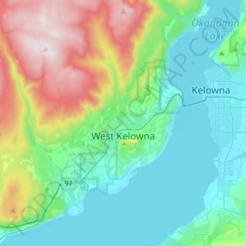
Name: West Kelowna topographic map, elevation, terrain.
Average elevation: 2,129 ft
Minimum elevation: 1,099 ft
Maximum elevation: 5,049 ft
Make a donation
Gear up for your next adventure:
As an Amazon Associate, this site earns from qualifying purchases at no extra cost to you.
Other topographic maps
Click on a map to view its topography, its elevation and its terrain.
The Commons Field
Canada > British Columbia > Regional District of Central Okanagan > Kelowna
Average elevation: 1,450 ft
Fintry
Canada > British Columbia > Regional District of Central Okanagan > West Central Okanagan Electoral Area
Average elevation: 1,434 ft
Pandosy
Canada > British Columbia > Regional District of Central Okanagan > Kelowna
Average elevation: 1,132 ft
Terrace Mountain
Canada > British Columbia > Regional District of Central Okanagan > West Central Okanagan Electoral Area
Average elevation: 5,095 ft
Make a donation
Gear up for your next adventure:
As an Amazon Associate, this site earns from qualifying purchases at no extra cost to you.
Mission Creek Regional Park
Canada > British Columbia > Regional District of Central Okanagan > Kelowna
Average elevation: 1,430 ft
Oyama
Canada > British Columbia > Regional District of Central Okanagan > Lake Country
Average elevation: 1,578 ft
Lake Country
Canada > British Columbia > Regional District of Central Okanagan > Lake Country > Lake Country
Average elevation: 1,732 ft
West Kelowna
Canada > British Columbia > Regional District of Central Okanagan > West Kelowna
Average elevation: 2,858 ft
Make a donation
Gear up for your next adventure:
As an Amazon Associate, this site earns from qualifying purchases at no extra cost to you.
Damer Lake
Canada > British Columbia > Regional District of Central Okanagan > East Central Okanagan Electoral Area
Average elevation: 4,439 ft
Browne Lake
Canada > British Columbia > Regional District of Central Okanagan > East Central Okanagan Electoral Area
Average elevation: 4,350 ft
Christie Lake
Canada > British Columbia > Regional District of Central Okanagan > West Central Okanagan Electoral Area
Average elevation: 4,751 ft
Little White Mountain
Canada > British Columbia > Regional District of Central Okanagan > East Central Okanagan Electoral Area
Average elevation: 6,348 ft
Make a donation
Gear up for your next adventure:
As an Amazon Associate, this site earns from qualifying purchases at no extra cost to you.
Black Knight Mountain
Canada > British Columbia > Regional District of Central Okanagan > East Central Okanagan Electoral Area
Average elevation: 3,255 ft
Knox Mountain
Canada > British Columbia > Regional District of Central Okanagan > Kelowna
Average elevation: 1,411 ft
Knox Mountain
Canada > British Columbia > Regional District of Central Okanagan > Kelowna
Average elevation: 1,411 ft
Moraine Park
Canada > British Columbia > Regional District of Central Okanagan > Kelowna
Average elevation: 1,339 ft
Make a donation
Gear up for your next adventure:
As an Amazon Associate, this site earns from qualifying purchases at no extra cost to you.
Oyama
Canada > British Columbia > Regional District of Central Okanagan > Lake Country
Average elevation: 1,578 ft
Moraine Park
Canada > British Columbia > Regional District of Central Okanagan > Kelowna
Average elevation: 1,339 ft