Geolocate

Walley topographic map

Click on the map to display elevation.

About this map

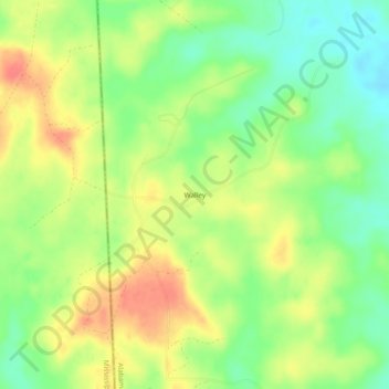
Name: Walley topographic map, elevation, terrain.

Location: Walley, Washington County, Alabama, United States (31.16462 -88.44502 31.20462 -88.40502)

Average elevation: 240 ft

Minimum elevation: 148 ft

Maximum elevation: 338 ft

Washington County trails, hiking, mountain biking, running and outdoor activities

Other topographic maps

Click on a map to view its topography, its elevation and its terrain.

McIntosh

United States > Alabama > Washington County

Average elevation: 43 ft

Millry

United States > Alabama > Washington County

Average elevation: 138 ft

McIntosh

United States > Alabama > Washington County > McIntosh

Average elevation: 43 ft

Chatom

United States > Alabama > Washington County

Average elevation: 157 ft

Gear up for your next adventure:

🏔️Mountain Trail Maps - High‑detail maps for popular peaks
🥾Hiking Shoes - Durable and comfortable shoes for trail hiking
🍳Camping Cook Set - Complete cookware for outdoor meals
🛠️Outdoor Gear Repair Kit - Essential tools to fix gear on the trail
🚪Portable Camp Chair - Foldable chair for comfort at camp

As an Amazon Associate, this site earns from qualifying purchases at no extra cost to you.