Chatom topographic map
Interactive map
Click on the map to display elevation.
About this map
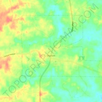
Name: Chatom topographic map, elevation, terrain.
Location: Chatom, Washington County, Alabama, 36518, United States (31.44280 -88.27979 31.49404 -88.19427)
Average elevation: 157 ft
Minimum elevation: 82 ft
Maximum elevation: 266 ft
Other topographic maps
Click on a map to view its topography, its elevation and its terrain.
Walley
United States > Alabama > Washington County
Walley, Washington County, Alabama, United States
Average elevation: 240 ft
Deer Park
United States > Alabama > Washington County
Deer Park, Washington County, Alabama, United States
Average elevation: 157 ft
Tibbie
United States > Alabama > Washington County > Tibbie
Tibbie, Washington County, Alabama, 36583, United States
Average elevation: 180 ft
McIntosh
United States > Alabama > Washington County > McIntosh
McIntosh, Washington County, Alabama, United States
Average elevation: 43 ft
Carson
United States > Alabama > Washington County
Carson, Washington County, Alabama, 36548, United States
Average elevation: 59 ft