Geolocate

Millry topographic map

Click on the map to display elevation.

About this map

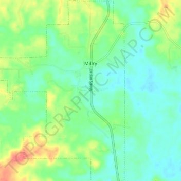
Name: Millry topographic map, elevation, terrain.

Location: Millry, Washington County, Alabama, United States (31.59554 -88.35630 31.65457 -88.30031)

Average elevation: 138 ft

Minimum elevation: 75 ft

Maximum elevation: 269 ft

Washington County trails, hiking, mountain biking, running and outdoor activities

Other topographic maps

Click on a map to view its topography, its elevation and its terrain.

Walley

United States > Alabama > Washington County

Average elevation: 240 ft

McIntosh

United States > Alabama > Washington County > McIntosh

Average elevation: 43 ft

Deer Park

United States > Alabama > Washington County

Average elevation: 157 ft

Tibbie

United States > Alabama > Washington County > Tibbie

Average elevation: 180 ft

Carson

United States > Alabama > Washington County

Average elevation: 59 ft

Gear up for your next adventure:

🪄Magnetic Compass - Accurate compass for navigation
🧭Hiking Compass - Precision compass for reliable navigation in the wilderness
🌎3D Topographic Globes - Raised relief globes for a tactile understanding of geography
👟Men's Trail Runners - Lightweight footwear for fast-paced exploration and light hiking
🧦Hiking Socks - Comfortable socks to prevent blisters on long hikes

As an Amazon Associate, this site earns from qualifying purchases at no extra cost to you.