
Mokhotlong District topographic map
Interactive map
Click on the map to display elevation.
About this map
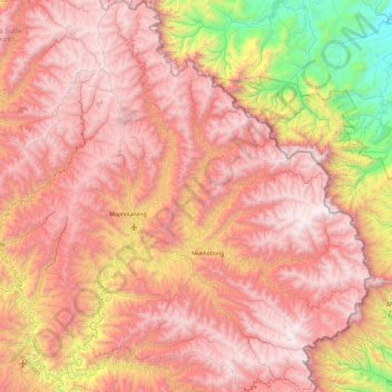
Name: Mokhotlong District topographic map, elevation, terrain.
Location: Mokhotlong District, Lesotho (-29.55669 28.55624 -28.75596 29.45571)
Average elevation: 8,031 ft
Minimum elevation: 3,412 ft
Maximum elevation: 11,371 ft
Other topographic maps
Click on a map to view its topography, its elevation and its terrain.
Mok'hoek'hoe Ha Motlalepula
Mok'hoek'hoe Ha Motlalepula, Mokhotlong District, Lesotho
Average elevation: 8,711 ft
Makhoabeng
Lesotho > Thaba-Tseka District
Makhoabeng, Thaba-Tseka District, 333, Lesotho
Average elevation: 7,064 ft
Tri-Kolo
Lesotho > Butha-Buthe District
Tri-Kolo, Butha-Buthe District, Lesotho
Average elevation: 10,482 ft
Mapoteng
Lesotho > Thaba-Tseka District
Mapoteng, Thaba-Tseka District, Lesotho
Average elevation: 7,963 ft
Ha Mapotsane
Lesotho > Mohale's Hoek District > Ha Mapotsane
Ha Mapotsane, Mohale's Hoek District, Lesotho
Average elevation: 5,289 ft
Drakensberg
Drakensberg, Mokhotlong District, Lesotho
Average elevation: 10,781 ft
Maseru
Maseru, Ha Tsiu, Maseru District, 100, Lesotho
Average elevation: 5,269 ft
Mohale's Hoek
Lesotho > Mohale's Hoek District > Mohale's Hoek
Mohale's Hoek, Mohale's Hoek District, Lesotho
Average elevation: 5,390 ft
Thabana Ntlenyana
Thabana Ntlenyana, Mokhotlong District, Lesotho
Average elevation: 10,869 ft