
Make a donation
Gear up for your next adventure:
As an Amazon Associate, this site earns from qualifying purchases at no extra cost to you.
Leribe District topographic map
Click on the map to display elevation.
Make a donation
Gear up for your next adventure:
As an Amazon Associate, this site earns from qualifying purchases at no extra cost to you.
Leribe District
In the west, Leribe borders on the Free State Province of South Africa. Domestically, it borders on the following districts: Butha-Buthe District in the north, Mokhotlong District in the east, Thaba-Tseka District in southeast and Berea District in southwest. The Western districts of Lesotho has a predominantly low land zone with an elevation of 1,500 m (4,900 ft) to 1,800 m (5,900 ft) above the sea level. These lands are the major agricultural zones in the country. The average annual rainfall in the country is 100 cm (39 in), most of which is received during the rainy season of October to April. Though it rains during all the months of the year, groundwater is limited on account of run-offs. The region has a temperate climate on account of the elevation and is humid during most parts of the year. The temperature in the low lands vary from 32 °C (90 °F) to −7 °C (19 °F) in the winter.
Make a donation
Gear up for your next adventure:
As an Amazon Associate, this site earns from qualifying purchases at no extra cost to you.
About this map
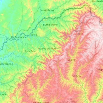
Name: Leribe District topographic map, elevation, terrain.
Location: Leribe District, Lesotho (-29.37080 27.63897 -28.69374 28.79248)
Average elevation: 7,060 ft
Minimum elevation: 4,865 ft
Maximum elevation: 10,988 ft
Make a donation
Gear up for your next adventure:
As an Amazon Associate, this site earns from qualifying purchases at no extra cost to you.
Other topographic maps
Click on a map to view its topography, its elevation and its terrain.
Make a donation
Gear up for your next adventure:
As an Amazon Associate, this site earns from qualifying purchases at no extra cost to you.
Make a donation
Gear up for your next adventure:
As an Amazon Associate, this site earns from qualifying purchases at no extra cost to you.