
Trnava topographic map
Click on the map to display elevation.
Trnava
The municipality lies at an altitude of 144 metres (472 ft) and covers an area of 71.53 km2 (27.62 sq mi) (2025). It is located in the Danubian Lowland on the Trnávka river, around 45 kilometres (28 mi) north-east of Bratislava, 50 kilometres (31 mi) west of Nitra and around 70 kilometres (43 mi) from the Czech border. The closest mountain ranges are the Little Carpathians to the west and the Považský Inovec to the north-east of the city.
About this map
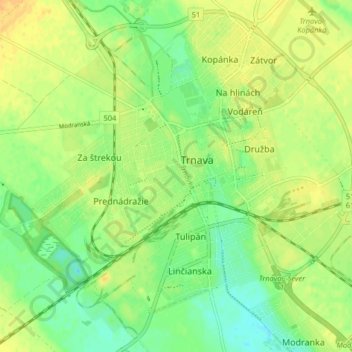
Name: Trnava topographic map, elevation, terrain.
Location: Trnava, District of Trnava, Region of Trnava, Slovakia (48.34915 17.54039 48.39942 17.62150)
Average elevation: 495 ft
Minimum elevation: 446 ft
Maximum elevation: 541 ft
Other topographic maps
Click on a map to view its topography, its elevation and its terrain.
Bratislava
Slovakia > Region of Bratislava > District of Bratislava I > Old Town
The Carpathian mountain range begins in city territory with the Little Carpathians (Malé Karpaty). The Záhorie and Danubian lowlands stretch into Bratislava. The city's lowest point is at the Danube's surface at 126 metres (413 ft) above mean sea level, and the highest point is Devínska Kobyla at 514 metres…
Average elevation: 574 ft
Tatra Mountains
The Tatras lie in the temperate zone of Central Europe. They are an important barrier to the movements of air masses. Their mountainous topography causes one of the most diverse climates in that region.
Average elevation: 3,284 ft
Prievidza
The municipality lies at an altitude of 309 metres (1,014 ft) and covers an area of 43.06 km2 (16.63 sq mi) (2025). The city is near the smaller town of Bojnice, sharing a public transport system. The valley of the Nitra River, in which the city lies, is surrounded by mountain ranges on all sides, in the west…
Average elevation: 1,135 ft
Bánovce nad Bebravou
The municipality lies at an altitude of 209 metres (686 ft) and covers an area of 26.45 km2 (10.21 sq mi) (2025).
Average elevation: 771 ft
Hamuliakovo
The municipality lies at an altitude of 128 metres (420 ft) and covers an area of 10.94 km2 (4.22 sq mi) (2025).
Average elevation: 413 ft
Nové Mesto nad Váhom
The municipality lies at an altitude of 189 metres (620 ft) and covers an area of 32.58 km2 (12.58 sq mi) (2025).
Average elevation: 751 ft
Želiezovce
The municipality lies at an altitude of 139 metres (456 ft) and covers an area of 56.52 km2 (21.82 sq mi) (2025).
Average elevation: 489 ft
Dolný Badín
The municipality lies at an altitude of 305 metres (1,001 ft) and covers an area of 6.24 km2 (2.41 sq mi) (2025).
Average elevation: 1,056 ft
Partizánske
The municipality lies at an altitude of 190 metres (620 ft) and covers an area of 22.37 km2 (8.64 sq mi) (2025).
Average elevation: 781 ft
Vysoká pri Morave
The municipality lies at an altitude of 144 metres (472 ft) and covers an area of 33.57 km2 (12.96 sq mi) (2025).
Average elevation: 472 ft
Prešov
The municipality lies at an altitude of 296 metres (971 ft) and covers an area of 71.09 km2 (27.45 sq mi) (2025). It is located in north-eastern Slovakia, at the northern reaches of the Košice Basin, at the confluence of the Torysa river with its tributary Sekčov. Mountain ranges nearby include Slanské…
Average elevation: 1,060 ft
Tatra Mountains
The Tatras lie in the temperate zone of Central Europe. They are an important barrier to the movements of air masses. Their mountainous topography causes one of the most diverse climates in that region.
Average elevation: 3,284 ft
Košice
Košice lies at an altitude of 206 metres (676 ft) above sea level and covers an area of 242.77 square kilometres (93.7 sq mi). It is located in eastern Slovakia, about 20 kilometres (12 mi) from the Hungarian, 80 kilometres (50 mi) from the Ukrainian, and 90 kilometres (56 mi) from the Polish borders. It is…
Average elevation: 1,030 ft
Vysoké Tatry
The town of Vysoké Tatry is special in many aspects. It is not a true town, but a conglomerate of separate and different settlements (originally separate villages), whose only common feature is that they are the main tourist resorts in the Slovak High Tatras, while being connected through a common railway…
Average elevation: 3,369 ft
Bratislava
Slovakia > Region of Bratislava
The Carpathian mountain range begins in city territory with the Little Carpathians (Malé Karpaty). The Záhorie and Danubian lowlands stretch into Bratislava. The city's lowest point is at the Danube's surface at 126 metres (413 ft) above mean sea level, and the highest point is Devínska Kobyla at 514 metres…
Average elevation: 564 ft
Nitra
Slovakia > Region of Nitra > District of Nitra
Nitra lies at an altitude of 190 metres (623 ft) above sea level and covers an area of 100.48 square kilometres (38.8 sq mi). It is located in the Nitra River valley in the Danubian Lowland, where the bigger part of the city is located. A smaller part is located at the southernmost reaches of the Tribeč…
Average elevation: 646 ft
Tatra Mountains
The Tatras lie in the temperate zone of Central Europe. They are an important barrier to the movements of air masses. Their mountainous topography causes one of the most diverse climates in that region.
Average elevation: 3,284 ft
Žilina
Žilina lies at an altitude of 342 metres (1,122 ft) above sea level and covers an area of 80.03 square kilometres (30.9 sq mi). It is located in the Upper Váh region (Slovak: Horné Považie) at the confluence of three rivers: Váh, flowing from the east into the south-west, Kysuca, flowing from the north…
Average elevation: 1,391 ft
Mníšek nad Popradom
The municipality lies at an altitude of 439 metres (1,440 ft) and covers an area of 17.93 km2 (6.92 sq mi) (2025). The village lies near the Poprad river and is directly at the border with Poland, with a 24-hour border crossing.
Average elevation: 1,916 ft
Sereď
The municipality lies at an altitude of 128 metres (420 ft) and covers an area of 30.72 km2 (11.86 sq mi) (2025). It is located in the Danubian Lowland on the Váh river, around 20 kilometres (12 mi) south-east of Trnava, 33 kilometres (21 mi) west of Nitra and around 55 kilometres (34 mi) east from…
Average elevation: 433 ft
Martin
Slovakia > Region of Žilina > District of Martin
Martin lies at an altitude of 395 metres (1,296 ft) above sea level and covers an area of 67.74 square kilometres (26.2 sq mi). It is located in northern Slovakia, in the Turiec Basin, just south of the confluence of the Turiec river with Váh. Mountain ranges in the proximity of the city are Malá Fatra…
Average elevation: 1,588 ft
Bratislava
Slovakia > Region of Bratislava
The Carpathian mountain range begins in city territory with the Little Carpathians (Malé Karpaty). The Záhorie and Danubian lowlands stretch into Bratislava. The city's lowest point is at the Danube's surface at 126 metres (413 ft) above mean sea level, and the highest point is Devínska Kobyla at 514 metres…
Average elevation: 551 ft
Rysy
It is possible to reach the peak from the Slovak side, starting at Štrbské pleso and passing Chata pod Rysmi, a mountain chalet at an altitude of 2,250 m (7,380 ft). Between November 1 and June 15, the trail and chalet on the Slovak side are closed.
Average elevation: 6,578 ft
Banská Bystrica
Slovakia > Region of Banská Bystrica > District of Banská Bystrica
Banská Bystrica lies at an altitude of 362 metres (1,188 ft) above sea level and covers an area of 103.37 square kilometres (39.9 sq mi). It is about halfway between Slovakia's two largest cities, 208 kilometres (129 mi) north-east from Slovakia's capital Bratislava and 217 kilometres (135 mi) west of…
Average elevation: 1,850 ft
Bratislava
Slovakia > Region of Bratislava
The Carpathian mountain range begins in city territory with the Little Carpathians (Malé Karpaty). The Záhorie and Danubian lowlands stretch into Bratislava. The city's lowest point is at the Danube's surface at 126 metres (413 ft) above mean sea level, and the highest point is Devínska Kobyla at 514 metres…
Average elevation: 551 ft
Tatra Mountains
The Tatras lie in the temperate zone of Central Europe. They are an important barrier to the movements of air masses. Their mountainous topography causes one of the most diverse climates in that region.
Average elevation: 3,284 ft
Mokrance
Slovakia > Region of Košice > District of Košice - okolie
The municipality lies at an altitude of 200 metres (660 ft) and covers an area of 23.41 km2 (9.04 sq mi) (2025).
Average elevation: 755 ft
Gerlachovský štít
Slovakia > Region of Prešov > District of Poprad
Gerlachovský štít (Slovak pronunciation, translated into English as Gerlachov Peak, German: Gerlsdorfer Spitze, Hungarian: Gerlachfalvi-csúcs), informally referred to as Gerlach, is the highest peak in the High Tatras, in Slovakia, and in the Carpathian Mountains. Its elevation is usually listed at 2654.4…
Average elevation: 6,900 ft
Trenčín
Trenčín lies at an altitude of 262 metres (860 ft) above sea level and covers an area of 82 square kilometres (31.7 sq mi). It lies in the Trenčín Basin of north-western Slovakia, which is surrounded by the Strážov Mountains, Považský Inovec and White Carpathians, with the last mentioned being a…
Average elevation: 1,007 ft
Štrba - Štrbské pleso
Slovakia > Region of Prešov > District of Poprad > Štrba
Average elevation: 5,240 ft
Bratislava
Slovakia > Region of Bratislava
The Carpathian mountain range begins in city territory with the Little Carpathians (Malé Karpaty). The Záhorie and Danubian lowlands stretch into Bratislava. The city's lowest point is at the Danube's surface at 126 metres (413 ft) above mean sea level, and the highest point is Devínska Kobyla at 514 metres…
Average elevation: 564 ft
Tomášovo
Slovakia > Region of Banská Bystrica > District of Rimavská Sobota > Hnúšťa > Polom
Average elevation: 2,129 ft
Kremnica
Slovakia > Region of Banská Bystrica
Kremnica lies at an altitude of 564 metres (1,850 ft) above sea level and covers an area of 43.136 square kilometres (16.7 sq mi). It is located in the Kremnica Mountains on the brook Kremnický potok, which is a tributary of the Hron River. It is located around 20 kilometres (12 mi) west of Banská Bystrica…
Average elevation: 2,579 ft
Banská Bystrica
Slovakia > Region of Banská Bystrica > District of Banská Bystrica
Banská Bystrica lies at an altitude of 368 metres (1,207 ft) above sea level and covers an area of 103.36 square kilometres (39.9 sq mi). It is about halfway between Slovakia's two largest cities, 208 kilometres (129 mi) north-east from Slovakia's capital Bratislava and 217 kilometres (135 mi) west of…
Average elevation: 1,424 ft
Piešťany
Piešťany is situated in the western part of Slovakia, in the valley of the Váh river, at an elevation of 162 metres (531.50 feet). The Považský Inovec mountains form the eastern boundary of this part of the Váh valley. The highest hill of these mountains, Inovec 1,042 m (3,418.64 ft), is about 25 km (16…
Average elevation: 643 ft
Michalovce
Slovakia > Region of Košice > District of Michalovce
The municipality lies at an altitude of 113 metres (371 ft) and covers an area of 52.80 km2 (20.39 sq mi) (2025).
Average elevation: 374 ft
Senica
Slovakia > Region of Trnava > District of Senica
The municipality lies at an altitude of 206 metres (676 ft) and covers an area of 50.33 km2 (19.43 sq mi) (2025).
Average elevation: 738 ft
Komárno
Slovakia > Region of Nitra > District of Komárno
The municipality lies at an altitude of 109 metres (358 ft) and covers an area of 103.16 km2 (39.83 sq mi) (2024).
Average elevation: 358 ft
Olováry
Slovakia > Region of Banská Bystrica > District of Veľký Krtíš
The municipality lies at an altitude of 190 metres (620 ft) and covers an area of 18.61 km2 (7.19 sq mi) (2025).
Average elevation: 692 ft
Prešov
Slovakia > Region of Prešov > District of Prešov
The municipality lies at an altitude of 296 metres (971 ft) and covers an area of 70.43 km2 (27.19 sq mi) (2024). It is located in north-eastern Slovakia, at the northern reaches of the Košice Basin, at the confluence of the Torysa river with its tributary Sekčov. Mountain ranges nearby include Slanské…
Average elevation: 1,030 ft
Bratislava
Slovakia > Region of Bratislava
The Carpathian mountain range begins in city territory with the Little Carpathians (Malé Karpaty). The Záhorie and Danubian lowlands stretch into Bratislava. The city's lowest point is at the Danube's surface at 126 metres (413 ft) above mean sea level, and the highest point is Devínska Kobyla at 514 metres…
Average elevation: 554 ft
Havran
Slovakia > Region of Prešov > District of Poprad > Tatranská Javorina
Average elevation: 5,328 ft
Veľká Javorina
Slovakia > Region of Trenčín > District of Nové Mesto nad Váhom
The massif of Velká Javořina is located in the southwest part of the White Carpathians and is built of flysch rocks with significant thickness, in which layers of sandstone (dating from the Upper Cretaceous to the Lower Paleocene) and fine-grained marine sediments (shales and marls) rhythmically repeat. The…
Average elevation: 2,539 ft
Plechotice
Slovakia > Region of Košice > District of Trebišov
The village lies at an altitude of 142 metres (466 ft) and covers an area of 12.936 km².
Average elevation: 492 ft
Marianka
Slovakia > Region of Bratislava > District of Malacky > Bratislava
The municipality lies at an altitude of 230 metres (750 ft) and covers an area of 3.22 km2 (1.24 sq mi) (2025).
Average elevation: 817 ft
Prievidza
Slovakia > Region of Trenčín > District of Prievidza
Prievidza lies at an altitude of 280 metres (919 ft) above sea level and covers an area of 43.06 square kilometres (16.6 sq mi). The city is situated very near the smaller but more famous town of Bojnice, actually sharing the public transport system. The valley of the Nitra River, in which the city lies, is…
Average elevation: 1,135 ft
Nitra
Nitra lies at an altitude of 190 metres (623 ft) above sea level and covers an area of 100.48 square kilometres (38.8 sq mi). It is located in the Nitra River valley in the Danubian Lowland, where the bigger part of the city is located. A smaller part is located at the southernmost reaches of the Tribeč…
Average elevation: 646 ft
Košice
Košice lies at an altitude of 206 metres (676 ft) above sea level and covers an area of 242.77 square kilometres (93.7 sq mi). It is located in eastern Slovakia, about 20 kilometres (12 mi) from the Hungarian, 80 kilometres (50 mi) from the Ukrainian, and 90 kilometres (56 mi) from the Polish borders. It is…
Average elevation: 1,030 ft
Stupava
Slovakia > Region of Bratislava
The town is located in the Záhorie lowland, under the Little Carpathians, around 15 km (9 mi) north of Bratislava at an altitude of 182 metres. It has 15, 095 inhabitants as of 2021 and has a land area of 67.17 km2 (26 sq mi). Apart from the core part of the city, Mást (German: Maaßt, Hungarian: Mászt),…
Average elevation: 778 ft
Tatra Mountains
The Tatras lie in the temperate zone of Central Europe. They are an important barrier to the movements of air masses. Their mountainous topography causes one of the most diverse climates in that region.
Average elevation: 3,284 ft
Palota
Slovakia > Region of Prešov > District of Medzilaborce
The municipality lies at an altitude of 482 metres (1,581 feet) and covers an area of 24.116 square kilometres (9.311 square miles). It has a population of about 190 people.
Average elevation: 1,880 ft
Low Tatras National Park
Slovakia > Region of Banská Bystrica > District of Brezno
Average elevation: 2,920 ft
Kriváň
Slovakia > Region of Prešov > District of Poprad > Vysoké Tatry
The relative elevations of the two mountains were determined by the English natural historian Robert Townson, who ascended both peaks in August 1793 and also made an early recorded comment on Kriváň's aesthetic appeal.
Average elevation: 6,276 ft