
Make a donation
Gear up for your next adventure:
As an Amazon Associate, this site earns from qualifying purchases at no extra cost to you.
Seville topographic map
Click on the map to display elevation.
Make a donation
Gear up for your next adventure:
As an Amazon Associate, this site earns from qualifying purchases at no extra cost to you.
Seville
Seville has an area of 141 km2 (54 sq mi), according to the National Topographic Map (Mapa Topográfico Nacional) series from the Instituto Geográfico Nacional – Centro Nacional de Información Geográfica, the country's civilian survey organisation (pages 984, 985 and 1002). The city is situated in the fertile valley of the River Guadalquivir. The average height above sea level is 7 metres (23 feet). Most of the city is on the east side of the river, while Triana, La Cartuja and Los Remedios are on the west side. The Aljarafe region lies further west, and is considered part of the metropolitan area. The city has boundaries on the north with La Rinconada, La Algaba and Santiponce; on the east with Alcalá de Guadaira; on the south with Dos Hermanas and Gelves and on the west with San Juan de Aznalfarache, Tomares and Camas.
Make a donation
Gear up for your next adventure:
As an Amazon Associate, this site earns from qualifying purchases at no extra cost to you.
About this map
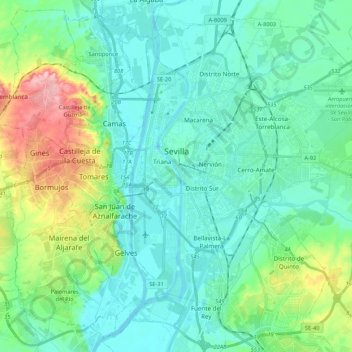
Name: Seville topographic map, elevation, terrain.
Location: Seville, Sevilla, Andalusia, Spain (37.30020 -6.03292 37.45296 -5.81916)
Average elevation: 115 ft
Minimum elevation: -7 ft
Maximum elevation: 538 ft
Make a donation
Gear up for your next adventure:
As an Amazon Associate, this site earns from qualifying purchases at no extra cost to you.
Other topographic maps
Click on a map to view its topography, its elevation and its terrain.
Ventas de Zafarraya
Spain > Andalusia > Comarca de Alhama
Ventas de Zafarraya is in the municipality of Alhama de Granada, Granada, Spain. It has an area of 19.23 square kilometres (7.42 sq mi) and is at an elevation of 920 metres (3,020 ft). As of 2019 the population was 1,181. The postal code is 18125. The village is on the road from Alhama de Granada in the west…
Average elevation: 3,035 ft
Make a donation
Gear up for your next adventure:
As an Amazon Associate, this site earns from qualifying purchases at no extra cost to you.
Málaga
Spain > Andalusia > Málaga-Costa del Sol > Málaga
Like many of the military fortifications that were constructed in Islamic Spain, the Alcazaba of Málaga featured a quadrangular plan. It was protected by an outer and inner wall, both supported by rectangular towers, between which a covered walkway led up the slope to the Gibralfaro (this was the only…
Average elevation: 705 ft
Busquístar
Spain > Andalusia > Comarca de la Alpujarra Granadina > Busquístar
Average elevation: 4,134 ft
Alhambra
Spain > Andalusia > Partido Judicial de Granada > Granada
During the reign of the Nasrid Dynasty, the Alhambra was transformed into a palatine city, complete with an irrigation system composed of aqueducts and water channels that provided water for the complex and for other nearby countryside palaces such as the Generalife. Previously, the old fortresses on the hill…
Average elevation: 2,490 ft
Make a donation
Gear up for your next adventure:
As an Amazon Associate, this site earns from qualifying purchases at no extra cost to you.
Make a donation
Gear up for your next adventure:
As an Amazon Associate, this site earns from qualifying purchases at no extra cost to you.
Make a donation
Gear up for your next adventure:
As an Amazon Associate, this site earns from qualifying purchases at no extra cost to you.
Sierra Nevada
Spain > Andalusia > Comarca de la Alpujarra Granadina > Lanjarón
Average elevation: 7,293 ft
Make a donation
Gear up for your next adventure:
As an Amazon Associate, this site earns from qualifying purchases at no extra cost to you.
Maroma
Spain > Andalusia > La Axarquía > Canillas de Aceituno
La Maroma, also known as Tejeda, at an altitude of 2069 m, is the highest peak of the Sierra de Tejeda, Penibaetic System, Spain. The summit is located in the region of Axarquía on the border between the provinces of Granada and Málaga.
Average elevation: 5,597 ft
Parque Natural Sierra de Tejeda, Almijara y Alhama
Spain > Andalusia > Comarca de Alhama
Average elevation: 2,474 ft
Make a donation
Gear up for your next adventure:
As an Amazon Associate, this site earns from qualifying purchases at no extra cost to you.
Make a donation
Gear up for your next adventure:
As an Amazon Associate, this site earns from qualifying purchases at no extra cost to you.
Make a donation
Gear up for your next adventure:
As an Amazon Associate, this site earns from qualifying purchases at no extra cost to you.
Make a donation
Gear up for your next adventure:
As an Amazon Associate, this site earns from qualifying purchases at no extra cost to you.
Sierra de la Huerta del Abad
Spain > Andalusia > Sierra de Huelva > Aracena > Carboneras
Average elevation: 1,722 ft
Make a donation
Gear up for your next adventure:
As an Amazon Associate, this site earns from qualifying purchases at no extra cost to you.
Jardines del Triunfo
Spain > Andalusia > Comarca de la Vega de Granada > Granada
Average elevation: 2,359 ft
Make a donation
Gear up for your next adventure:
As an Amazon Associate, this site earns from qualifying purchases at no extra cost to you.
Cortijo ruinas
Spain > Andalusia > Comarca de la Alpujarra Granadina > Capileira
Average elevation: 7,369 ft
Make a donation
Gear up for your next adventure:
As an Amazon Associate, this site earns from qualifying purchases at no extra cost to you.
Pico de Mulhacén
Spain > Andalusia > Partido Judicial de Órgiva > Trevélez
Mulhacén ([mulaˈθen]), with an elevation of 3,479 metres (11,414 ft), is the highest mountain in peninsular Spain and in all of the Iberian Peninsula. It is part of the Sierra Nevada range in the Penibaetic System. It is named after Abu'l-Hasan Ali, known as Muley Hacén in Spanish, the penultimate Muslim…
Average elevation: 10,072 ft
Make a donation
Gear up for your next adventure:
As an Amazon Associate, this site earns from qualifying purchases at no extra cost to you.
Make a donation
Gear up for your next adventure:
As an Amazon Associate, this site earns from qualifying purchases at no extra cost to you.
Pico de Mulhacén
Spain > Andalusia > Comarca de la Alpujarra Granadina > Trevélez
Mulhacén ([mulaˈθen]), with an elevation of 3,482 metres (11,424 ft), is the highest mountain in peninsular Spain and in all of the Iberian Peninsula. It is part of the Sierra Nevada range in the Penibaetic System. It is named after Abu'l-Hasan Ali, known as Muley Hacén in Spanish, the penultimate Muslim…
Average elevation: 10,072 ft
Make a donation
Gear up for your next adventure:
As an Amazon Associate, this site earns from qualifying purchases at no extra cost to you.
Pilas de Algaida
Spain > Andalusia > Comarca de Alhama > Alhama de Granada
Average elevation: 3,143 ft
Make a donation
Gear up for your next adventure:
As an Amazon Associate, this site earns from qualifying purchases at no extra cost to you.
Make a donation
Gear up for your next adventure:
As an Amazon Associate, this site earns from qualifying purchases at no extra cost to you.
Poblado de Doña Blanca
Spain > Andalusia > Bay of Cádiz > El Puerto de Santa María
Average elevation: 43 ft
Make a donation
Gear up for your next adventure:
As an Amazon Associate, this site earns from qualifying purchases at no extra cost to you.
Make a donation
Gear up for your next adventure:
As an Amazon Associate, this site earns from qualifying purchases at no extra cost to you.
Los Caldereros
Spain > Andalusia > Sierra de Huelva > Arroyomolinos de León
Average elevation: 1,991 ft
Make a donation
Gear up for your next adventure:
As an Amazon Associate, this site earns from qualifying purchases at no extra cost to you.
Peñon de Bodíjar
Spain > Andalusia > Comarca de la Costa Granadina > Los Guájares
Average elevation: 2,854 ft
El Encinarillo
Spain > Andalusia > Comarca de la Alpujarra Granadina > Válor
Average elevation: 5,633 ft
Make a donation
Gear up for your next adventure:
As an Amazon Associate, this site earns from qualifying purchases at no extra cost to you.
Make a donation
Gear up for your next adventure:
As an Amazon Associate, this site earns from qualifying purchases at no extra cost to you.
La Colonia
Spain > Andalusia > Partido Judicial de Baza > Cuevas del Campo
Average elevation: 2,749 ft
Make a donation
Gear up for your next adventure:
As an Amazon Associate, this site earns from qualifying purchases at no extra cost to you.
La Antilla
Spain > Andalusia > Costa Occidental > Lepe
La Antilla is located along the southern coast of Spain, near the border with Portugal. Its average elevation is 12 meters above the sea level.
Average elevation: 39 ft
Make a donation
Gear up for your next adventure:
As an Amazon Associate, this site earns from qualifying purchases at no extra cost to you.
Make a donation
Gear up for your next adventure:
As an Amazon Associate, this site earns from qualifying purchases at no extra cost to you.