
Villaricos topographic map
Click on the map to display elevation.
About this map
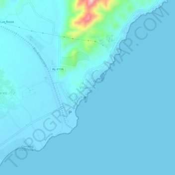
Name: Villaricos topographic map, elevation, terrain.
Average elevation: 52 ft
Minimum elevation: -10 ft
Maximum elevation: 843 ft
Other topographic maps
Click on a map to view its topography, its elevation and its terrain.
Seville
Seville has an area of 141 km2 (54 sq mi), according to the National Topographic Map (Mapa Topográfico Nacional) series from the Instituto Geográfico Nacional – Centro Nacional de Información Geográfica, the country's civilian survey organisation (pages 984, 985 and 1002). The city is situated in the…
Average elevation: 115 ft
Málaga
Spain > Andalusia > Málaga-Costa del Sol
Like many of the military fortifications that were constructed in Islamic Spain, the Alcazaba of Málaga featured a quadrangular plan. It was protected by an outer and inner wall, both supported by rectangular towers, between which a covered walkway led up the slope to the Gibralfaro (this was the only…
Average elevation: 906 ft
Granada
Spain > Andalusia > Comarca de la Vega de Granada
Granada (Spanish: [ɡɾaˈnaða], locally [ɡɾaˈna]) is the capital city of the province of Granada, in the autonomous community of Andalusia, Spain. Granada is located at the foot of the Sierra Nevada mountains, at the confluence of four rivers, the Darro, the Genil, the Monachil and the Beiro. Ascribed to…
Average elevation: 2,720 ft
Villanueva de Córdoba
The municipality is located in the comarca of Los Pedroches, in northern Córdoba province. It lies at an elevation of about 725 metres above sea level, within the largest continuous dehesa (oak pasture) in Europe. The area is dominated by holm oaks and is used for grazing Iberian pigs and sheep.
Average elevation: 2,008 ft
Marbella
Spain > Andalusia > Costa del Sol Occidental
There are five geomorphological units: the Sierra Blanca, the Sierra Blanca piedmont (foothills), the lower hill country, the plains and the coastal dunes. The Sierra Blanca is most centrally located in the province, looming over the old village. This mountain range has three peaks: La Concha, located further…
Average elevation: 709 ft
Monda
Spain > Andalusia > Sierra de las Nieves
Monda is a town and municipality in the province of Málaga, part of the autonomous community of Andalusia in southern Spain. It is located near Sierra Blanca and Sierra de las Nieves in the comarca of Sierra de las Nieves. The municipality is situated approximately 44 kilometres from the provincial capital of…
Average elevation: 1,660 ft
Estepona
Spain > Andalusia > Costa del Sol Occidental
Estepona (Spanish pronunciation: [esteˈpona]) is a town and municipality in the comarca of the Costa del Sol, southern Spain. It is located in the province of Málaga, part of the autonomous community of Andalusia. Its district covers an area of 137 square kilometers in a fertile valley crossed by small…
Average elevation: 869 ft
Benaoján
Spain > Andalusia > Serranía de Ronda
Benaoján (Spanish pronunciation: [benaoˈxan]) is a town and municipality in the province of Málaga, part of the autonomous community of Andalusia in southern Spain. It is located within the Sierra de Grazalema Natural Park. Its surface area is 32 km2. The municipality is situated approximately 17 kilometers…
Average elevation: 2,743 ft
Alhambra
Spain > Andalusia > Partido Judicial de Granada > Granada
During the reign of the Nasrid Dynasty, the Alhambra was transformed into a palatine city, complete with an irrigation system composed of aqueducts and water channels that provided water for the complex and for other nearby countryside palaces such as the Generalife. Previously, the old fortresses on the hill…
Average elevation: 2,490 ft
Córdoba
The differences in elevation in the Valley are very small, ranging from 100 and 170 metres above sea level, with the city proper located at an average altitude of roughly 125 metres above sea level. The landscape of the valley is further subdivided in the piedmont connecting with the Sierra, the fluvial…
Average elevation: 922 ft
Medina Sidonia
Medina Sidonia is a city and municipality in the province of Cádiz in the autonomous community of Andalusia, southern Spain. Considered by some to be the oldest city in Europe, it is used as a military defence location because of its elevation.
Average elevation: 223 ft
Algatocín
Spain > Andalusia > Serranía de Ronda
Algatocín is a town and municipality in the province of Málaga, part of the autonomous community of Andalusia in southern Spain. The municipality is situated approximately 143 kilometres (89 mi) from Málaga and 30 kilometres (19 mi) from Ronda. It is located in the west of the province in the Valle del…
Average elevation: 1,850 ft
Almeria
During the winter, daily maximum temperatures tend to stay around 17–18 °C (63–64 °F). At night, the minimum temperature is usually around 8–10 °C (47–50 °F). This makes Almería the city with the second warmest winters in Spain and Europe, just after Cádiz. The city only receives 26 days of…
Average elevation: 318 ft
Cómpeta
Spain > Andalusia > La Axarquía
The highest point visible from the town is the Maroma (2,065 m). The topography of the terminus is quite hilly, especially in the northwest, which borders the province of Granada. Other important elevations are Cerro Lucero (1,779 m), Cisne (1,600 m), Verde (1,554 m) and Tajo de las Grajas, which has a length…
Average elevation: 2,277 ft
Granada
Spain > Andalusia > Comarca de la Vega de Granada
Granada (Spanish: [ɡɾaˈnaða], locally [ɡɾaˈna]) is the capital city of the province of Granada, in the autonomous community of Andalusia, Spain. Granada is located at the foot of the Sierra Nevada mountains, at the confluence of four rivers, the Darro, the Genil, the Monachil and the Beiro. Ascribed to…
Average elevation: 2,720 ft
Cádiz
Spain > Andalusia > Bay of Cádiz
The Baluarte de la Candelaria (fortress or stronghold of Candlemas) is a military fortification. Taking advantage of a natural elevation of land, it was constructed in 1672 at the initiative of the governor, Diego Caballero de Illescas. Protected by a seaward-facing wall that had previously served as a…
Average elevation: 3 ft
Cádiz
The entire province of Cádiz has a Mediterranean climate, mostly Köppen Csa but also Csb in high altitude areas. Large differences in summer temperatures exist between the three official stations in Cádiz, Jerez, and Tarifa depending on position relative to the coastline. Tarifa is exceptionally mild for…
Average elevation: 417 ft
Seville
Seville has an area of 141 km2 (54 sq mi), according to the National Topographic Map (Mapa Topográfico Nacional) series from the Instituto Geográfico Nacional – Centro Nacional de Información Geográfica, the country's civilian survey organisation (pages 984, 985 and 1002). The city is situated in the…
Average elevation: 115 ft
Marbella
Spain > Andalusia > Costa del Sol Occidental
There are five geomorphological areas in Marbella—the Sierra Blanca, the Sierra Blanca piedmont (foothills), the lower hill country, the plains and the coastal dunes. The Sierra Blanca is the most centrally-located in the province, peaking behind the old village. The mountain range has three notable…
Average elevation: 709 ft
Río Tinto
The ore body was deposited during the Carboniferous period (300–350 Ma) by hydrothermal activities on the sea floor. The history of mining in the Rio Tinto area traces back to the Tartessans and the Iberians starting mining in 3000 BC, followed by the Phoenicians, Greeks, Romans, Visigoths, and Moors. The…
Average elevation: 538 ft
Cádiz
Spain > Andalusia > Bay of Cádiz
The Baluarte de la Candelaria (fortress or stronghold of Candlemas) is a military fortification. Taking advantage of a natural elevation of land, it was constructed in 1672 at the initiative of the governor, Diego Caballero de Illescas. Protected by a seaward-facing wall that had previously served as a…
Average elevation: 3 ft
Mijas
Spain > Andalusia > Costa del Sol Occidental
The climate changes gradually with increasing elevation in the mountains. Temperatures can drop to 10 °C (50 °F). In the peaks, over 600 m (2,000 ft) high, some ice may form in winter, while precipitation increases to almost 800 mm (32 in).
Average elevation: 561 ft
Málaga
Spain > Andalusia > Málaga-Costa del Sol
Like many of the military fortifications that were constructed in Islamic Spain, the Alcazaba of Málaga featured a quadrangular plan. It was protected by an outer and inner wall, both supported by rectangular towers, between which a covered walkway led up the slope to the Gibralfaro (this was the only…
Average elevation: 906 ft
Güéjar Sierra
Spain > Andalusia > Comarca de la Vega de Granada
Güéjar Sierra is a village and municipality located in the province of Granada, Spain. According to the INE, it had a population of 2,988 at the start of 2010. The village is situated in the north-western part of the Sierra Nevada mountain range, at an altitude of 1,088 metres. The municipality borders Pinos…
Average elevation: 5,154 ft
Chiclana de la Frontera
Spain > Andalusia > Bay of Cádiz
Chiclana de la Frontera (Spanish pronunciation: [tʃiˈklana ðe la fɾonˈteɾa]) is a town and municipality in southwestern Spain, in the province of Cádiz, Andalucía, near the Gulf of Cádiz. It belongs to the association of municipalities of the Bay of Cádiz (Bahía de Cádiz), the provincial capital of…
Average elevation: 79 ft
Almonte
Spain > Andalusia > El Condado
Almonte is a town and municipality located in the province of Huelva, in southwestern Spain. According to the 2022 census, it had a population of 25,448 inhabitants, ranking third within its province, just after Huelva, the capital city and Lepe. With its 859.21 km2 (33174 sq mi), it is the 19th largest…
Average elevation: 75 ft
Seville
Seville has an area of 141 km2 (54 sq mi), according to the National Topographic Map (Mapa Topográfico Nacional) series from the Instituto Geográfico Nacional – Centro Nacional de Información Geográfica, the country's civilian survey organisation (pages 984, 985 and 1002). The city is situated in the…
Average elevation: 115 ft
Alhaurín el Grande
Spain > Andalusia > Valle del Guadalhorce > Alhaurín el Grande
Average elevation: 955 ft
Antequera
In 2011, Antequera had a population of 41,854. It covers an area of 749.34 km2 with a population density of 55.85 inhabitants/km2, and is situated at an altitude of 575 meters. There is also a very small town named "Gloriano" in the bottom of Antequera. Antequera is the most populous city in the interior of…
Average elevation: 1,870 ft
Córdoba
The differences in elevation in the Valley are very small, ranging from 100 and 170 metres above sea level, with the city proper located at an average altitude of roughly 125 metres above sea level. The landscape of the valley is further subdivided in the piedmont connecting with the Sierra, the fluvial…
Average elevation: 922 ft
Málaga
Spain > Andalusia > Málaga-Costa del Sol
Like many of the military fortifications that were constructed in Islamic Spain, the Alcazaba of Málaga featured a quadrangular plan. It was protected by an outer and inner wall, both supported by rectangular towers, between which a covered walkway led up the slope to the Gibralfaro (this was the only…
Average elevation: 906 ft
Cazorla
Cazorla lies at an elevation of 836 metres on the western slope of the Sierra de Cazorla. It is the entry point and base for visits to the Natural Park of Sierras de Cazorla, Segura y Las Villas Natural Park, a vast protected area of magnificent river gorges and forests. Spain's second longest river, the…
Average elevation: 3,048 ft
Lucena
Lucena is located in the transition zone between the campiña in the Guadalquivir Depression and the Subbaetic system, at an altitude above mean sea level slightly below 500 meters. The Subbaetic system include neighboring subranges such as the sierras of Cabra, Carcabuey, Pollos, Horconera, and Rute.
Average elevation: 1,562 ft
Sierra Nevada
Spain > Andalusia > Comarca de la Alpujarra Granadina > Lanjarón
Average elevation: 7,293 ft