Geolocate

Axton topographic map

Click on the map to display elevation.

About this map

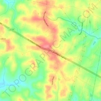
Name: Axton topographic map, elevation, terrain.

Location: Axton, Henry County, Virginia, 24054, United States (36.63958 -79.73198 36.67958 -79.69198)

Average elevation: 928 ft

Minimum elevation: 791 ft

Maximum elevation: 1,053 ft

Henry County trails, hiking, mountain biking, running and outdoor activities

Other topographic maps

Click on a map to view its topography, its elevation and its terrain.

Chatmoss

United States > Virginia > Henry County

Average elevation: 801 ft

Oak Level

United States > Virginia > Henry County

Average elevation: 1,073 ft

Sandy Level

United States > Virginia > Henry County > Sandy Level

Average elevation: 689 ft

Stanleytown

United States > Virginia > Henry County

Average elevation: 850 ft

Laurel Park

United States > Virginia > Henry County

Average elevation: 748 ft

Gear up for your next adventure:

🧭Pro Hiking Compasses - High-accuracy liquid-filled compasses for topographic orientation
🏕️Family Camping Gear - Essentials for group camping trips
🧭GPS Watch Accessories - Bands and chargers for GPS watches
🚑Emergency Bivvies - Heat-reflective sleeping bags for survival situations
🪶Survival Guide Book - Expert advice for emergency preparedness

As an Amazon Associate, this site earns from qualifying purchases at no extra cost to you.