
Spoleto topographic map
Click on the map to display elevation.
About this map
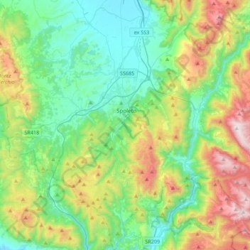
Name: Spoleto topographic map, elevation, terrain.
Location: Spoleto, Perugia, Umbria, 06049, Italy (42.59684 12.55810 42.84351 12.84654)
Average elevation: 2,093 ft
Minimum elevation: 656 ft
Maximum elevation: 5,512 ft
Other topographic maps
Click on a map to view its topography, its elevation and its terrain.
Castelleone
Italy > Umbria > Perugia > Deruta
Castelleone is a frazione of the comune of Deruta in the Province of Perugia, Umbria, central Italy. It stands at an elevation of 398 metres above sea level. At the time of the Istat census of 2001 it had 91 inhabitants.
Average elevation: 1,135 ft
Vaiano
Italy > Umbria > Perugia > Castiglione del Lago
Vaiano is a frazione of the comune of Castiglione del Lago in the Province of Perugia, Umbria, central Italy. It stands at an elevation of 371 metres above sea level. At the time of the Istat census of 2001 it had 234 inhabitants.
Average elevation: 1,004 ft
Ponticelli
Ponticelli is a frazione of the comune of Città della Pieve in the Province of Perugia, Umbria, central Italy. It stands at an elevation of 249 metres above sea level. At the time of the Istat census of 2001 it had 610 inhabitants.
Average elevation: 902 ft
Casalalta
Italy > Umbria > Perugia > Collazzone
Casalalta is a frazione of the comune of Collazzone in the Province of Perugia, Umbria, central Italy. It stands at an elevation of 325 metres above sea level. At the time of the Istat census of 2001 it had 60 inhabitants.
Average elevation: 896 ft
San Leo Bastia
Italy > Umbria > Perugia > Città di Castello
San Leo Bastia is a frazione of the comune of Città di Castello in the Province of Perugia, Umbria, central Italy. It stands at an elevation of 320 metres above sea level. At the time of the Istat census of 2001 it had 213 inhabitants.
Average elevation: 1,325 ft
Pettino
Italy > Umbria > Perugia > Campello sul Clitunno
It stands at an elevation of 1074 metres above sea level. At the time of the Istat census of 2001, it had only 74 inhabitants.
Average elevation: 3,743 ft