
Make a donation
Gear up for your next adventure:
As an Amazon Associate, this site earns from qualifying purchases at no extra cost to you.
Saint-Jean-de-Maurienne topographic map
Click on the map to display elevation.
Make a donation
Gear up for your next adventure:
As an Amazon Associate, this site earns from qualifying purchases at no extra cost to you.
Saint-Jean-de-Maurienne
Saint-Jean-de-Maurienne is on the route of the future Lyon-Turin rail link. Homes, businesses, the current railway station and the rescue centre are affected by the project. The Lyon Turin Railway company (LTF) which manages the construction projects plans to build new railway station in the Sous-le-Bourg neighborhood, serving both the historic line and the new Lyon-Turin line. Geological and topographical investigations are underway. The project promises to be even more complex than that of the Channel Tunnel.
Make a donation
Gear up for your next adventure:
As an Amazon Associate, this site earns from qualifying purchases at no extra cost to you.
About this map
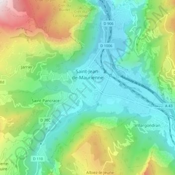
Name: Saint-Jean-de-Maurienne topographic map, elevation, terrain.
Average elevation: 3,104 ft
Minimum elevation: 1,654 ft
Maximum elevation: 6,627 ft
Make a donation
Gear up for your next adventure:
As an Amazon Associate, this site earns from qualifying purchases at no extra cost to you.
Other topographic maps
Click on a map to view its topography, its elevation and its terrain.
Mollard Durand
France > Auvergne-Rhône-Alpes > Savoy > Saint-Martin-de-la-Porte
Average elevation: 3,445 ft
Les Ménuires
France > Auvergne-Rhône-Alpes > Savoy
The resort was founded in 1964 and has an altitude range of 1,850 m (6,070 ft).
Average elevation: 6,768 ft
Make a donation
Gear up for your next adventure:
As an Amazon Associate, this site earns from qualifying purchases at no extra cost to you.
Le Charvet
France > Auvergne-Rhône-Alpes > Savoy > Bourg-Saint-Maurice > Arc 1800
Average elevation: 5,417 ft
Make a donation
Gear up for your next adventure:
As an Amazon Associate, this site earns from qualifying purchases at no extra cost to you.
Le Désert d'Entremont
France > Auvergne-Rhône-Alpes > Savoy > Entremont-le-Vieux
Average elevation: 3,809 ft
La Ville des Glaciers
France > Auvergne-Rhône-Alpes > Savoy > Bourg-Saint-Maurice
Average elevation: 7,152 ft
Le Grand Couloir
France > Auvergne-Rhône-Alpes > Savoy > Pralognan-la-Vanoise
Average elevation: 6,155 ft
Make a donation
Gear up for your next adventure:
As an Amazon Associate, this site earns from qualifying purchases at no extra cost to you.
Make a donation
Gear up for your next adventure:
As an Amazon Associate, this site earns from qualifying purchases at no extra cost to you.
Make a donation
Gear up for your next adventure:
As an Amazon Associate, this site earns from qualifying purchases at no extra cost to you.
La Chiserette
France > Auvergne-Rhône-Alpes > Savoy > Champagny-en-Vanoise
Average elevation: 6,329 ft
Make a donation
Gear up for your next adventure:
As an Amazon Associate, this site earns from qualifying purchases at no extra cost to you.
Dou des Ponts
France > Auvergne-Rhône-Alpes > Savoy > Pralognan-la-Vanoise
Average elevation: 6,243 ft
Make a donation
Gear up for your next adventure:
As an Amazon Associate, this site earns from qualifying purchases at no extra cost to you.
Le Laisonnay d'En Bas
France > Auvergne-Rhône-Alpes > Savoy > Champagny-en-Vanoise
Average elevation: 7,021 ft
Make a donation
Gear up for your next adventure:
As an Amazon Associate, this site earns from qualifying purchases at no extra cost to you.