
Cederberg topographic map
Click on the map to display elevation.
About this map
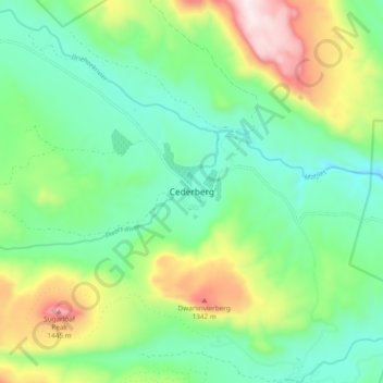
Name: Cederberg topographic map, elevation, terrain.
Average elevation: 3,271 ft
Minimum elevation: 2,523 ft
Maximum elevation: 4,928 ft
Other topographic maps
Click on a map to view its topography, its elevation and its terrain.
Malmesbury
South Africa > Western Cape > West Coast District Municipality > Swartland Local Municipality
Average elevation: 561 ft
Bulshoek Dam
South Africa > Western Cape > West Coast District Municipality > Cederberg Local Municipality
Average elevation: 604 ft
Swartland Local Municipality
South Africa > Western Cape > West Coast District Municipality
Average elevation: 377 ft
Matzikama Ward 8
South Africa > Western Cape > West Coast District Municipality > Matzikama Local Municipality
Average elevation: 1,089 ft
Darling Wildflower Nature Reserve
South Africa > Western Cape > West Coast District Municipality > Swartland Local Municipality > Darling
Average elevation: 486 ft
Saldanha Bay Local Municipality
South Africa > Western Cape > West Coast District Municipality
Average elevation: 197 ft
Cederberg Local Municipality
South Africa > Western Cape > West Coast District Municipality
Average elevation: 1,401 ft
Matzikama Local Municipality
South Africa > Western Cape > West Coast District Municipality
Average elevation: 1,014 ft
Cederberg Ward 1
South Africa > Western Cape > West Coast District Municipality > Cederberg Local Municipality
Average elevation: 2,264 ft
West Coast National Park
South Africa > Western Cape > West Coast District Municipality
Average elevation: 151 ft
Bergrivier Local Municipality
South Africa > Western Cape > West Coast District Municipality
Average elevation: 591 ft
Clanwilliam Dam
South Africa > Western Cape > West Coast District Municipality > Cederberg Local Municipality > Clanwilliam
Average elevation: 948 ft
Dassen Island
South Africa > Western Cape > West Coast District Municipality > Swartland Local Municipality
Average elevation: 7 ft
Cederberg Local Municipality
South Africa > Western Cape > West Coast District Municipality
Average elevation: 1,401 ft
Cederberg Local Municipality
South Africa > Western Cape > West Coast District Municipality
Average elevation: 1,401 ft
Cederberg Local Municipality
South Africa > Western Cape > West Coast District Municipality
Average elevation: 1,401 ft
Dassen Island
South Africa > Western Cape > West Coast District Municipality > Swartland Local Municipality
Average elevation: 7 ft
Krom
South Africa > Western Cape > West Coast District Municipality > Cederberg Local Municipality
Average elevation: 2,854 ft
Cape Floral Region Protected Areas
South Africa > Western Cape > West Coast District Municipality
Average elevation: 1,106 ft
Saldanha Bay Ward 6
South Africa > Western Cape > West Coast District Municipality > Saldanha Bay Local Municipality
Average elevation: 174 ft
Malmesbury
South Africa > Western Cape > West Coast District Municipality > Swartland Local Municipality
Average elevation: 561 ft
Matzikama Local Municipality
South Africa > Western Cape > West Coast District Municipality
Average elevation: 1,014 ft
Darling Wildflower Nature Reserve
South Africa > Western Cape > West Coast District Municipality > Swartland Local Municipality > Darling
Average elevation: 486 ft
Die Hel
South Africa > Western Cape > West Coast District Municipality > Bergrivier Local Municipality
Average elevation: 2,037 ft
Cederberg Local Municipality
South Africa > Western Cape > West Coast District Municipality
Average elevation: 1,401 ft