
Matzikama Local Municipality topographic map
Click on the map to display elevation.
About this map
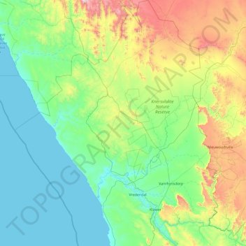
Name: Matzikama Local Municipality topographic map, elevation, terrain.
Average elevation: 1,014 ft
Minimum elevation: 0 ft
Maximum elevation: 5,246 ft
Other topographic maps
Click on a map to view its topography, its elevation and its terrain.
Vredenburg
South Africa > Western Cape > West Coast District Municipality > Saldanha Bay Local Municipality
Average elevation: 299 ft
Saint Helena Bay
South Africa > Western Cape > West Coast District Municipality > Saldanha Bay Local Municipality
Average elevation: 148 ft
Riebeek-Kasteel
South Africa > Western Cape > West Coast District Municipality > Swartland Local Municipality
Average elevation: 610 ft
Moorreesburg
South Africa > Western Cape > West Coast District Municipality > Swartland Local Municipality
Average elevation: 564 ft
Clanwilliam
South Africa > Western Cape > West Coast District Municipality > Cederberg Local Municipality
Clanwilliam is situated at an elevation of 100 metres (330 ft), between the western slopes of the Cederberg mountains and the east bank of the Olifants River, which is impounded there by the Clanwilliam Dam. It is located just off the N7 national road, which runs from Cape Town to the Namibian border, and on…
Average elevation: 531 ft
Vredendal
South Africa > Western Cape > West Coast District Municipality > Matzikama Local Municipality
Average elevation: 167 ft
Saldanha
South Africa > Western Cape > West Coast District Municipality > Saldanha Bay Local Municipality
Average elevation: 89 ft
Langebaan
South Africa > Western Cape > West Coast District Municipality > Saldanha Bay Local Municipality
Average elevation: 112 ft
Yzerfontein
South Africa > Western Cape > West Coast District Municipality > Swartland Local Municipality
Average elevation: 26 ft
Citrusdal
South Africa > Western Cape > West Coast District Municipality > Cederberg Local Municipality
Average elevation: 840 ft
Piketberg
South Africa > Western Cape > West Coast District Municipality > Bergrivier Local Municipality
Average elevation: 869 ft
Vanrhynsdorp
South Africa > Western Cape > West Coast District Municipality > Matzikama Local Municipality
Average elevation: 456 ft
Wolfberg Arch
South Africa > Western Cape > West Coast District Municipality > Cederberg Local Municipality > Cederberg
Average elevation: 4,636 ft
Klawer
South Africa > Western Cape > West Coast District Municipality > Matzikama Local Municipality
Average elevation: 466 ft
Bulshoek Dam
South Africa > Western Cape > West Coast District Municipality > Cederberg Local Municipality
Average elevation: 604 ft
Porterville
South Africa > Western Cape > West Coast District Municipality > Bergrivier Local Municipality
Average elevation: 679 ft
Koekenaap
South Africa > Western Cape > West Coast District Municipality > Matzikama Local Municipality
Average elevation: 151 ft
Elandsbaai
South Africa > Western Cape > West Coast District Municipality > Cederberg Local Municipality
Average elevation: 141 ft
Darling
South Africa > Western Cape > West Coast District Municipality > Swartland Local Municipality
Average elevation: 512 ft
Koringberg
South Africa > Western Cape > West Coast District Municipality > Swartland Local Municipality
Average elevation: 495 ft
Redelinghuys
South Africa > Western Cape > West Coast District Municipality > Bergrivier Local Municipality
Average elevation: 348 ft
Darling Wildflower Nature Reserve
South Africa > Western Cape > West Coast District Municipality > Swartland Local Municipality > Darling
Average elevation: 486 ft
Strandfontein
South Africa > Western Cape > West Coast District Municipality > Matzikama Local Municipality
Average elevation: 118 ft
Hopefield
South Africa > Western Cape > West Coast District Municipality > Saldanha Bay Local Municipality
Average elevation: 190 ft
Lambert's Bay
South Africa > Western Cape > West Coast District Municipality > Cederberg Local Municipality
Average elevation: 62 ft
Kalbaskraal
South Africa > Western Cape > West Coast District Municipality > Swartland Local Municipality
Average elevation: 246 ft
Tafelberg
South Africa > Western Cape > West Coast District Municipality > Cederberg Local Municipality
Average elevation: 5,007 ft
Sneeuberg
South Africa > Western Cape > West Coast District Municipality > Cederberg Local Municipality
Average elevation: 5,059 ft
Dassen Island
South Africa > Western Cape > West Coast District Municipality > Swartland Local Municipality
Average elevation: 7 ft
Cederberg
South Africa > Western Cape > West Coast District Municipality > Cederberg Local Municipality
Average elevation: 3,944 ft
Moorreesburg
South Africa > Western Cape > West Coast District Municipality > Swartland Local Municipality
Average elevation: 564 ft
Velddrif
South Africa > Western Cape > West Coast District Municipality > Bergrivier Local Municipality
Average elevation: 26 ft
Saldanha
South Africa > Western Cape > West Coast District Municipality > Saldanha Bay Local Municipality
Average elevation: 89 ft
Langebaan
South Africa > Western Cape > West Coast District Municipality > Saldanha Bay Local Municipality
Average elevation: 112 ft
Aurora
South Africa > Western Cape > West Coast District Municipality > Bergrivier Local Municipality
Average elevation: 446 ft
Velddrif
South Africa > Western Cape > West Coast District Municipality > Bergrivier Local Municipality > Velddrif
Average elevation: 26 ft
Clanwilliam
South Africa > Western Cape > West Coast District Municipality > Cederberg Local Municipality
Clanwilliam is situated at an elevation of 100 metres (330 ft), between the western slopes of the Cederberg mountains and the east bank of the Olifants River, which is impounded there by the Clanwilliam Dam. It lies just off the N7 national road, which runs from Cape Town to the Namibian border, and on the…
Average elevation: 531 ft
Hopefield
South Africa > Western Cape > West Coast District Municipality > Saldanha Bay Local Municipality
Average elevation: 190 ft
Redelinghuys
South Africa > Western Cape > West Coast District Municipality > Bergrivier Local Municipality
Average elevation: 348 ft
Velddrif
South Africa > Western Cape > West Coast District Municipality > Bergrivier Local Municipality
Average elevation: 26 ft
Vredendal
South Africa > Western Cape > West Coast District Municipality > Matzikama Local Municipality
Average elevation: 167 ft
Dassen Island
South Africa > Western Cape > West Coast District Municipality > Swartland Local Municipality
Average elevation: 7 ft
Vredenburg
South Africa > Western Cape > West Coast District Municipality > Saldanha Bay Local Municipality
Average elevation: 299 ft
Uitkyk
South Africa > Western Cape > West Coast District Municipality > Matzikama Local Municipality
Average elevation: 177 ft
Krom
South Africa > Western Cape > West Coast District Municipality > Cederberg Local Municipality
Average elevation: 2,854 ft
Piketberg
South Africa > Western Cape > West Coast District Municipality > Bergrivier Local Municipality
Average elevation: 869 ft
Koekenaap
South Africa > Western Cape > West Coast District Municipality > Matzikama Local Municipality
Average elevation: 151 ft
Darling Wildflower Nature Reserve
South Africa > Western Cape > West Coast District Municipality > Swartland Local Municipality > Darling
Average elevation: 486 ft
Die Hel
South Africa > Western Cape > West Coast District Municipality > Bergrivier Local Municipality
Average elevation: 2,037 ft
Paternoster
South Africa > Western Cape > West Coast District Municipality > Saldanha Bay Local Municipality
Average elevation: 66 ft
Graafwater
South Africa > Western Cape > West Coast District Municipality > Cederberg Local Municipality
Average elevation: 646 ft