
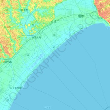
Sosa topographic map
Interactive map
Click on the map to display elevation.
About this map
Name: Sosa topographic map, elevation, terrain.
Location: Sosa, Chiba Prefecture, Japan (35.47779 140.48621 35.76116 140.73285)
Average elevation: 23 ft
Minimum elevation: -3 ft
Maximum elevation: 243 ft
Sōsa is located in far northeastern Chiba Prefecture. It is bordered to the north by the Pacific Ocean on the southwest. The land is mostly flat, and much is from 40 to 50 meters above sea level in average elevation.
Other topographic maps
Click on a map to view its topography, its elevation and its terrain.
Mount Fuji
Japan > Sunto County > Oyama
Mount Fuji, Oyama, Sunto County, Shizuoka Prefecture, Chubu Region, Japan
Average elevation: 10,699 ft
Nishi Mera
Nishi Mera, Koyu County, Miyazaki Prefecture, Japan
Average elevation: 2,152 ft
Lake Ashi
Japan > Ashigarashimo County > Hakone
Lake Ashi, Hakone, Ashigarashimo County, Kanagawa Prefecture, Japan
Average elevation: 2,851 ft
Maborikaigan 4-chome Park
Maborikaigan 4-chome Park, Maboricho 3-chome, Yokosuka, Kanagawa Prefecture, 238-8550, Japan
Average elevation: 72 ft
Ibaraki
Ibaraki, Higashiibaraki County, Ibaraki Prefecture, 311-3116, Japan
Average elevation: 85 ft
Lake Sanaru
Lake Sanaru, Hamamatsu, Shizuoka Prefecture, Chubu Region, Japan
Average elevation: 52 ft
Motoyama
Motoyama, Nagaoka County, Kochi Prefecture, 781-3601, Japan
Average elevation: 2,228 ft
Setouchi
Setouchi, Oshima County, Kagoshima Prefecture, Japan
Average elevation: 85 ft
Higashishirakawa
Higashishirakawa, Kamo County, Gifu Prefecture, Chubu Region, 509-1392, Japan
Average elevation: 2,159 ft
Odai
Odai, Taki County, Mie Prefecture, 519-2404, Japan
Average elevation: 1,250 ft
Nishikigaoka-chuo Park
Nishikigaoka-chuo Park, Nishikigaoka 2-chome, Aoba Ward, Sendai, Miyagi Prefecture, Japan
Average elevation: 646 ft