
Make a donation
Gear up for your next adventure:
As an Amazon Associate, this site earns from qualifying purchases at no extra cost to you.
Ulaanbaatar topographic map
Click on the map to display elevation.
Make a donation
Gear up for your next adventure:
As an Amazon Associate, this site earns from qualifying purchases at no extra cost to you.
Ulaanbaatar
Ulaanbaatar (/ʊˌlɑːn ˈbɑːtər/; Mongolian: Улаанбаатар, pronounced [ʊˌɮaːɴ‿ˈpaːʰtə̆r] , lit. 'Red Hero'), previously anglicized as Ulan Bator, is the capital and most populous city of Mongolia. It has a population of 1.6 million, and it is the coldest capital city in the world by average yearly temperature. The municipality is located in north central Mongolia at an elevation of about 1,300 metres (4,300 ft) in a valley on the Tuul River. The city was founded in 1639 as a nomadic Buddhist monastic centre, changing location 28 times, and was permanently settled at its modern location in 1778.
Make a donation
Gear up for your next adventure:
As an Amazon Associate, this site earns from qualifying purchases at no extra cost to you.
About this map
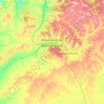
Name: Ulaanbaatar topographic map, elevation, terrain.
Location: Ulaanbaatar, Mongolia (47.30196 106.36261 48.27193 108.50078)
Average elevation: 5,039 ft
Minimum elevation: 3,317 ft
Maximum elevation: 9,150 ft
Make a donation
Gear up for your next adventure:
As an Amazon Associate, this site earns from qualifying purchases at no extra cost to you.
Other topographic maps
Click on a map to view its topography, its elevation and its terrain.
Отгонтэнгэр
Mongolia > Zavkhan > Aldarkhaan
Otgontenger (/ˌɒtɡɒnˈtɛŋɡər/; Mongolian: Отгонтэнгэр [ˈɔʰtχɞɴtʰɪŋɡɪ̆r]; lit. 'The Youngest Sky') is the highest peak in the Khangai Mountains in Mongolia. Its summit is currently calculated to reach an elevation of 4,010 meters above mean sea level (some earlier topographic…
Average elevation: 11,145 ft
Make a donation
Gear up for your next adventure:
As an Amazon Associate, this site earns from qualifying purchases at no extra cost to you.
Make a donation
Gear up for your next adventure:
As an Amazon Associate, this site earns from qualifying purchases at no extra cost to you.
Make a donation
Gear up for your next adventure:
As an Amazon Associate, this site earns from qualifying purchases at no extra cost to you.
Make a donation
Gear up for your next adventure:
As an Amazon Associate, this site earns from qualifying purchases at no extra cost to you.
Make a donation
Gear up for your next adventure:
As an Amazon Associate, this site earns from qualifying purchases at no extra cost to you.
Make a donation
Gear up for your next adventure:
As an Amazon Associate, this site earns from qualifying purchases at no extra cost to you.
Choibalsan
Choibalsan (Mongolian: Чойбалсан) is the fourth-largest city in Mongolia after Ulaanbaatar, Darkhan, and Erdenet. The name of the city was Bayan Tümen (Баян Түмэн) until 1941, when it was renamed after the communist leader Khorloogiin Choibalsan in honor of the 20th anniversary of the…
Average elevation: 2,507 ft
Make a donation
Gear up for your next adventure:
As an Amazon Associate, this site earns from qualifying purchases at no extra cost to you.
Make a donation
Gear up for your next adventure:
As an Amazon Associate, this site earns from qualifying purchases at no extra cost to you.
Make a donation
Gear up for your next adventure:
As an Amazon Associate, this site earns from qualifying purchases at no extra cost to you.
Make a donation
Gear up for your next adventure:
As an Amazon Associate, this site earns from qualifying purchases at no extra cost to you.
Choir
Mongolia > Govisumber > Sumber
Choir lies in the Choir Depression, a lowland strip about 150 km long and 10 to 20 km wide, about 500 m lower than the surrounding upland. It lies at an altitude of 1269 m.
Average elevation: 4,206 ft
Ulaanbaatar
Mongolia > Ulaanbaatar > Ulaanbaatar
Ulaanbaatar (/ˌuːlɑːn ˈbɑːtər/; Mongolian: Улаанбаатар, , lit. "Red Hero"), previously anglicized as Ulan Bator, is the capital and most populous city of Mongolia. The municipality is located in north central Mongolia at an elevation of about 1,300 metres (4,300 ft) in a valley on the Tuul…
Average elevation: 5,056 ft
Make a donation
Gear up for your next adventure:
As an Amazon Associate, this site earns from qualifying purchases at no extra cost to you.
Make a donation
Gear up for your next adventure:
As an Amazon Associate, this site earns from qualifying purchases at no extra cost to you.
Make a donation
Gear up for your next adventure:
As an Amazon Associate, this site earns from qualifying purchases at no extra cost to you.