
关累镇 topographic map
Interactive map
Click on the map to display elevation.
About this map
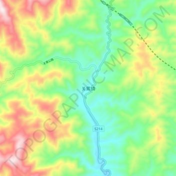
Name: 关累镇 topographic map, elevation, terrain.
Location: 关累镇, 勐腊县, 西双版纳傣族自治州, 云南省, 666300, 中国 (21.66010 101.24634 21.74010 101.32634)
Average elevation: 2,723 ft
Minimum elevation: 1,886 ft
Maximum elevation: 4,098 ft
Other topographic maps
Click on a map to view its topography, its elevation and its terrain.
西双版纳热带植物园-百竹园
西双版纳热带植物园-百竹园, 勐仑镇, 勐腊县, 西双版纳傣族自治州, 云南省, 666100, 中国
Average elevation: 1,834 ft