
勐腊县 topographic map
Interactive map
Click on the map to display elevation.
About this map
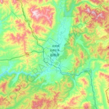
Name: 勐腊县 topographic map, elevation, terrain.
Location: 勐腊县, 西双版纳傣族自治州, 云南省, 666100, 中国 (21.30185 101.40503 21.62185 101.72503)
Average elevation: 3,058 ft
Minimum elevation: 1,906 ft
Maximum elevation: 5,328 ft
地處雲南省最南端,北緯21°09′-22°23′,東經101°05′-101°50′之間。海拔高度在480-2023米之間, 平均海拔1000米。全縣整個地勢東北部高,西南部和南部低,西邊為瀾滄江大斷裂,北邊是無量山南端之尾稍,形成較多南北走向的山嶺和盆地,北部中山山原坡狀起伏,中部岩溶景觀,南部為寬谷盆地。
Other topographic maps
Click on a map to view its topography, its elevation and its terrain.
西双版纳热带植物园-百竹园
西双版纳热带植物园-百竹园, 勐仑镇, 勐腊县, 西双版纳傣族自治州, 云南省, 666100, 中国
Average elevation: 1,834 ft