
象明彝族乡 topographic map
Interactive map
Click on the map to display elevation.
About this map
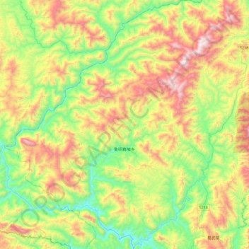
Name: 象明彝族乡 topographic map, elevation, terrain.
Location: 象明彝族乡, 勐腊县, 西双版纳傣族自治州, 云南省, 666300, 中国 (21.96192 101.09257 22.37603 101.45453)
Average elevation: 3,560 ft
Minimum elevation: 1,854 ft
Maximum elevation: 6,289 ft
Other topographic maps
Click on a map to view its topography, its elevation and its terrain.
西双版纳热带植物园-百竹园
西双版纳热带植物园-百竹园, 勐仑镇, 勐腊县, 西双版纳傣族自治州, 云南省, 666100, 中国
Average elevation: 1,834 ft