
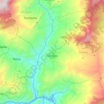
Garagoa topographic map
Interactive map
Click on the map to display elevation.
About this map
Name: Garagoa topographic map, elevation, terrain.
Average elevation: 6,522 ft
Minimum elevation: 4,085 ft
Maximum elevation: 10,745 ft
Garagoa (Spanish pronunciation: [ɡaɾaˈɣoa]) is a town and municipality in Colombia, located in the Boyacá Department. It covers an area of 191.75 km2 and the urban centre is located at an altitude of 1,650 metres (5,410 ft) above sea level. Parts of the municipality reach altitudes of 3,050 metres (10,010 ft). It is the capital of the province of Neira. It is also the seat of the Diocese of Garagoa of the Catholic Church. The municipality is situated in the Eastern Ranges of the Colombian Andes and borders Chinavita in the north, Macanal in the south, Tenza and Sutatenza in the west and Miraflores and Chinavita in the east.
Other topographic maps
Click on a map to view its topography, its elevation and its terrain.
Cordillera Oriental
Cordillera Oriental, Güicán, Gutiérrez, Boyacá, Colombia
Average elevation: 15,830 ft
Villa de Leiva
Colombia > Boyacá > Villa de Leyva > Villa de Leiva
Villa de Leiva, Villa de Leyva, Ricaurte, Boyacá, Colombia
Average elevation: 7,136 ft
Villa de Leyva
Villa de Leyva, Ricaurte, Boyacá, RAP (Especial) Central, Colombia
Average elevation: 7,927 ft
Miraflores
Colombia > Boyacá > Miraflores
Miraflores, Lengupá, Boyacá, Colombia
Average elevation: 6,375 ft
Ventaquemada
Colombia > Boyacá > Ventaquemada > Ventaquemada
Ventaquemada, Márquez, Boyacá, 153640, Colombia
Average elevation: 9,229 ft
Villa de Leyva
Colombia > Boyacá > Villa de Leyva
Villa de Leyva, Boyacá, 15401, Colombia
Average elevation: 8,770 ft