
Paipa topographic map
Interactive map
Click on the map to display elevation.
About this map
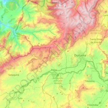
Name: Paipa topographic map, elevation, terrain.
Location: Paipa, Tundama, Boyacá, Colombia (5.65858 -73.24099 6.00415 -73.05193)
Average elevation: 9,281 ft
Minimum elevation: 6,240 ft
Maximum elevation: 13,241 ft
Paipa is located 15 km west of Duitama and 48 kilometres (30 mi) to the northeast of Tunja, the capital of the department, in the Cordillera Oriental (Eastern Ranges) of the Colombian Andes. It is the main tourist center of the region, with a number of large hotels and hot springs. At an elevation of 2525 m, the climate is mild with an average of 14° Celsius.
Other topographic maps
Click on a map to view its topography, its elevation and its terrain.
Cordillera Oriental
Cordillera Oriental, Güicán, Gutiérrez, Boyacá, Colombia
Average elevation: 15,830 ft
Villa de Leiva
Colombia > Boyacá > Villa de Leyva > Villa de Leiva
Villa de Leiva, Villa de Leyva, Ricaurte, Boyacá, Colombia
Average elevation: 7,136 ft
Miraflores
Colombia > Boyacá > Miraflores
Miraflores, Lengupá, Boyacá, Colombia
Average elevation: 6,375 ft
Villa de Leyva
Villa de Leyva, Ricaurte, Boyacá, RAP (Especial) Central, Colombia
Average elevation: 7,927 ft
Ventaquemada
Colombia > Boyacá > Ventaquemada > Ventaquemada
Ventaquemada, Márquez, Boyacá, 153640, Colombia
Average elevation: 9,229 ft
Villa de Leyva
Colombia > Boyacá > Villa de Leyva
Villa de Leyva, Boyacá, 15401, Colombia
Average elevation: 8,770 ft